FTB 08-25-2015: Shifting of the Ridge Brings Changes to the Forecast

Issue Date: 8/25/2015
Issue Time: 8:35 AM

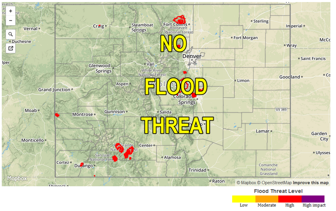
NO FLOOD THREAT IS FORECAST.

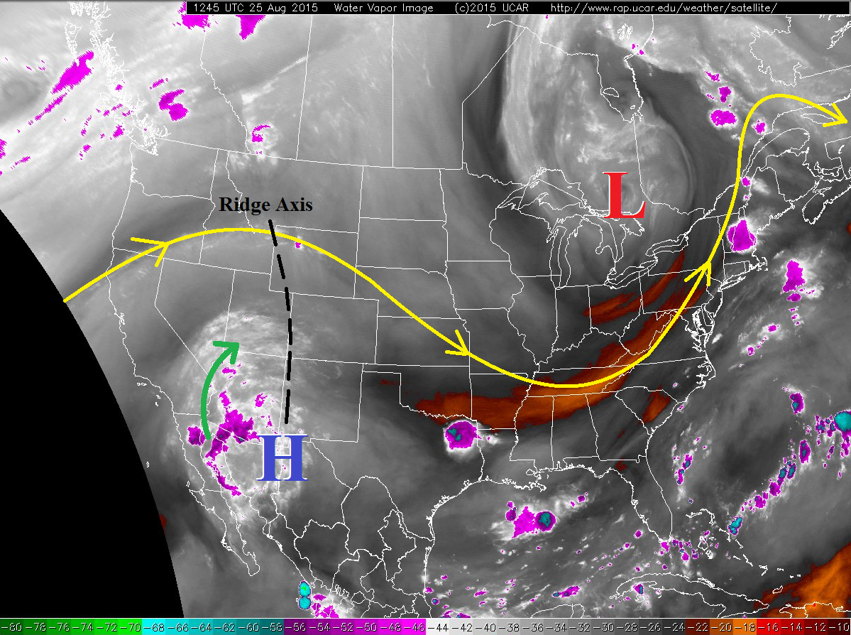
Subtle changes to the environment compared to yesterday will bring slight changes to the forecast, but no flood threat will unfold. The mid-/upper-level ridge axis, depicted on the water vapor imagery below, will shift slightly eastward, allowing a bit more moisture to make its way into Colorado this afternoon and evening. The moisture will bring a slight uptick in thunderstorm activity over/near the mountains, including the Urban Corridor and Palmer Ridge regions. The Northeast and Southeast Plains will hold a low possibility for isolated thunderstorms, with chances diminishing from west to east.

08252015_WV

Overall, most showers and thunderstorms will be of the garden variety. Scattered coverage is expected across the Central Mountains, Southwest Slope, San Juan Mountains, Grand Valley, and Southeast Mountains regions, with more isolated coverage over the Northern Mountains, Northwest Slope, and Front Range. The San Luis Valley should stay dry, with the surrounding mountains experiencing scattered showers/thunderstorms.

Further east, the Urban Corridor, western portions of the Southeast Plains, and Palmer Ridge should see a couple isolated thunderstorms move overhead, with the best relative chances over the Palmer Ridge. Outflow boundaries from mountain convection will try and force development of an isolated thunderstorm or two further east over the Plains regions, but will struggle to do so with mid-level temperatures being difficult to overcome.

Activity will tend to diminish after sunset, especially for low elevations, but a few mountain showers/thunderstorms will remain through the night as moisture continues to be transported into Colorado from the west/southwest.

Today’s Flood Threat Map

For more information on today’s flood threat, see the map below (hover over threat areas for more details). For Zone-Specific forecasts, jump below the map.

Flood Threat Legend

Zone-Specific Forecasts

Urban Corridor, Northeast Plains, Raton Ridge, Palmer Ridge, and Southeast Plains:

Isolated thunderstorms expected this afternoon and evening, with the best chances near the mountains and over preferred terrain of the Palmer Ridge. Gusty outflow winds and lightning will be the main threats, but localized, brief, moderate-to-heavy rainfall will be possible. Otherwise, mostly sunny skies and warm temperatures will be experienced.

Timing: 2 PM – 11 PM

Front Range, Northern Mountains, and Northwest Slope:

Isolated showers/thunderstorms expected, with the best relative chances across the Front Range. Gusty outflow winds, light rain, and lightning will be the main threats, but localized, brief moderate rainfall will be possible across southern portions of the Front Range. Rain rates will general be 0.15-0.35 inches/hour, but a strong storm over the southern Front Range could drop 0.5-0.8 inches/hour.

Timing: Noon – 8 PM

Central Mountains, San Juan Mountains, Southwest Slope, Southeast Mountains, San Luis Valley, and Grand Valley:

Scattered showers and thunderstorms expected over/near the mountains. Lower valleys will stay mainly dry, with only a couple isolated storms drifting off the mountains and overhead. Activity will begin to increase shortly after 11 AM, and continue into the overnight hours across the mountains where moisture continues to increase from the west-southwest. Localized brief moderate-to-heavy rainfall will be possible with stronger thunderstorms across the Southwest Slope and San Juan Mountains, but storm motions will be quick/erratic enough to mitigate any potential flood threat. Near bank-full conditions may be found in smaller streams in those regions, but flash flooding is not expected. The flash flood threat will increase tomorrow as moisture continues to uptick and the additional support of a shortwave disturbance is expected.

Timing: 11 AM – 11 PM, with a few showers and thunderstorms continuing overnight and into tomorrow morning across the southwestern quadrant of Colorado.

FTB 08-24-2015: High Pressure In Control For Today, But Changes On The Way

Issue Date: 8/24/2015
Issue Time: 9:45AM

— NO FLOOD THREAT TODAY

The high-pressure ridge located over Northern Mexico will briefly strengthen today, as shown in the water vapor image below. Morning precipitable water values are quite low, in the 0.45 to 0.6 inch range. Although there is some relatively higher moisture over NM and AZ, the majority of this moisture will not make it to Colorado today. That will change in the coming days (see our Flood Threat Outlook). Instead, for today we expect a very similar evolution to the weather as yesterday. Mostly sunny to partly cloudy skies will continue to dominate over most of the state. A few showers and weak thunderstorms will pop up across the very southern tier of Colorado, along the New Mexico border. Warming mid-level temperatures will imply very limited instability once again, and generally light rainfall amounts are expected. Thus, there is no flood threat today.

watervapor_20150824Today’s Flood Threat Map

For more information on today’s flood threat, see the map below (hover over threat areas for more details). For Zone-Specific forecasts, jump below the map.

Flood Threat Legend

Zone Specific Forecasts

Front Range, Urban Corridor, Northeast Plains, Southeast Plains, Palmer Ridge, Raton Ridge, Southeast Mountains:

Mostly sunny to partly cloudy today and seasonably warm with highs in the 60s in the higher terrain to the lower 90s F in the lower elevations of the Arkansas River valley. Widely scattered thunderstorms will pop along the Raton Ridge, Southeast Mountains and in the Southeast Plains from the mid-afternoon to early evening. However, max 1-hour rainfall rates will be limited to 0.5 inches or less due to weak instability. Flooding is not expected today.

Southwest Slope, San Juans, San Luis Valley, Central Mountains, Northern Mountains, Grand Valley, Northwest Slope, Southwest Slope:

Mostly sunny and cooler today with highs ranging from the 50s in the highest terrain to the low-90s in the lower valleys. Scattered showers and thunderstorms will occur over the San Juan Mountains and Southwest Slope, but 1-hr rainfall rates will be less than 0.4 inches. Flooding is not expected today.

FTB 08-23-2015: Mostly Dry and Cooler For Most

Issue Date: 8/23/2015
Issue Time: 9:55AM

— NO Flood Threat Today
Elevated Fire Threat for Northwest Slope, Northern Mountains and Central Mountains

The passage of yesterday’s cool front will mean continued mostly dry conditions and an 8-12 F drop in this afternoon’s temperatures across most of Colorado. However, as shown by the water vapor image, below, not everyone will stay dry. A weak monsoon surge is noted across New Mexico. This has raised precipitable water (PW) values up to about 1 inch in Albuquerque, while readings in Colorado range from 0.45 to 0.8 inches (higher towards the south). A brief influx of moister air will imply a chance of showers and weak thunderstorms across roughly the southern third of Colorado. However, instability will be very weak and prevent heavy rainfall. Mid and upper-level winds will turn to the west by early evening, and should bring in drier air across most of the state, which will shut off all rainfall around or even before sunset. Flooding is not expected today.

watervapor_20150823

Today’s Flood Threat Map

For more information on today’s flood threat, see the map below (hover over threat areas for more details). For Zone-Specific forecasts, jump below the map.
nofloodthreat_snapshot

Zone Specific Forecasts

Front Range, Urban Corridor, Northeast Plains, Southeast Plains, Palmer Ridge, Raton Ridge, Southeast Mountains:

Mostly sunny to partly cloudy today and much cooler with highs in the 50s in the higher terrain to the upper 80s F in the lower elevations of the Arkansas River valley. Isolated to widely scattered thunderstorms will pop along the Raton Ridge, Southeast Mountains and in the Southeast Plains from the mid afternoon to early evening. However, rainfall will be limited to 0.4 inches or less due to weak instability. Flooding is not expected today.

Southwest Slope, San Juans, San Luis Valley, Central Mountains, Northern Mountains, Grand Valley, Northwest Slope, Southwest Slope:

Mostly sunny and cooler today with highs ranging from the 50s in the highest terrain to the low-90s in the lower valleys. Scattered showers and thunderstorms will occur over the San Juan Mountains and San Luis Valley, but rainfall will be less than 0.4 inches. Flooding is not expected today. Relative humidity values will once again be in the 10-15% range over the Northwest Slope, Northern mountains and Central Mountains, which will slightly elevate the wildfire threat. However, wind speeds are expected to remain weak today. Please check with your local National Weather Service Forecasts for detailed information.

FTB 08-22-2015: Dry Air To Prevail Yet Again

Issue Date: 8/22/2015
Issue Time: 9:20AM

— NO Flood Threat Today
Elevated Fire Threat West of the Northwest Slope and Northern Mountains

Dry air continues its firm grip over most of Colorado. As the water vapor image shows, below, this will continue for today. A developing surface low pressure system, located over western South Dakota will move quickly northeast away from Colorado. The net effect for us will be subsidence and the advection of more dry air from the northwest. A cool front is expected to pass across the Northeast and Southeast Plains this afternoon. This could lead to stray showers and a weak thunderstorm, but with very little rainfall. Otherwise, a bit of residual moisture and diurnal upslope circulation will likely result in some showers and weak thunderstorms over the San Juans. Again, however, rainfall amounts will not be enough to raise flooding concerns. Looking out to Sunday, another push of fall-like air will approach the state from the northeast. This will lower temperatures by 5-10 degrees. Overall, a nice late summer weekend is in store for Colorado.

watervapor_20150822

An elevated fire threat continues today for the Northern Mountains and Northwest Slope where afternoon relative humidity values will drop into the 10-15% range. Gusty winds will also promote a fire danger. Meanwhile, we expect some of the hazy conditions to ease up a bit this afternoon as our airflow comes in from a more westerly, as opposed to northwesterly component. However, at least some haziness will persist through the day.

Today’s Flood Threat Map

For more information on today’s flood threat, see the map below (hover over threat areas for more details). For Zone-Specific forecasts, jump below the map.
nofloodthreat_snapshot

Zone Specific Forecasts

Front Range, Urban Corridor, Northeast Plains, Southeast Plains, Palmer Ridge, Raton Ridge, Southeast Mountains:

Mostly sunny and seasonally warm today with highs in the 60s in the higher terrain to near 100 F in the lower elevations of the Arkansas River valley. A stray thunderstorm cannot be ruled out along the Palmer Ridge and in the Southeast Plains during the late afternoon and early evening. However, rainfall will be limited to 0.3 inches. Flooding is not expected today.

Southwest Slope, San Juans, San Luis Valley, Central Mountains, Northern Mountains, Grand Valley, Northwest Slope, Southwest Slope:

Mostly sunny and warm today with highs ranging from the mid 60s in the highest terrain to the mid 90s in the lower valleys. A few showers and weak thunderstorms will be possible over the San Juan Mountains, but rainfall will be less than 0.2 inches. Over the Northwest Slope and Northern Mountains, relative humidity values are expected to drop into the 10-20% range today. This, combined with gusty winds will cause an elevated wildfire threat. Please check your local National Weather Forecasts for more detailed fire risk information.