FTB 09-02-2015: Weak Monsoon Disturbance Brings a Low Flood Threat

Issue Date: 09/02/2015
Issue Time: 9:02 AM

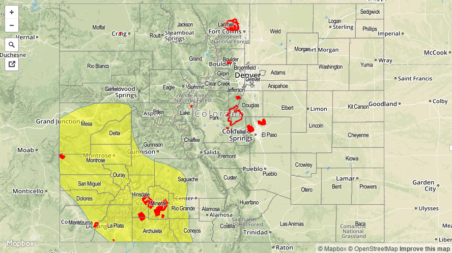
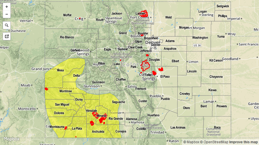
A LOW FLOOD THREAT IS ISSUED FOR PORTIONS OF THE SAN JUAN MOUNTAINS, GRAND VALLEY, AND SOUTHWEST SLOPE REGIONS.

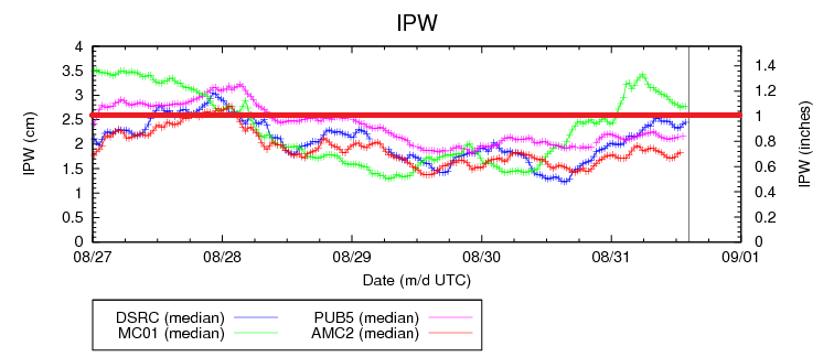
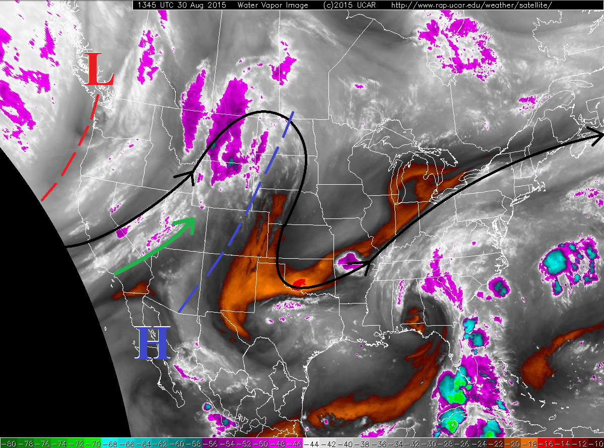
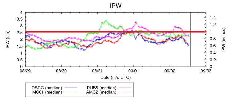
Subtropical moisture continues to stream in from the southwest, leaving precipitable water values just above average statewide. The IPW graph below shows the tale of the continuing moisture, although no locations are above 1 inch at this time. That will change this afternoon/evening as a weak disturbance moves into southwestern Colorado, likely pushing the Grand Junction reading near, or just above, 1 inch. This increase in moisture and support provided by the weak disturbance combine to warrant a low flood threat across the San Juan Mountains, Grand Valley, and Southwest Slope regions. Overall, scattered showers and thunderstorms are expected across the higher terrain today, mainly along and west of the Continental Divide, with more isolated-to-scattered coverage along the Front Range and Southeast Mountains.

IPW_09022015

Lower valleys in the high country will likely see scattered showers/thunderstorms move overhead thanks to west-southwesterly steering winds. For areas adjacent to the mountains, i.e., the Urban Corridor, and western portions of the Southeast Plains/Raton Ridge/Palmer Ridge, a couple isolated showers/weak thunderstorms will move overhead, but not much is expected. Some light rain and gusty outflow winds will be about all they can muster. Further east, the atmosphere will stay capped today with high temperatures climbing into the upper 80s to mid-90s.

Today’s Flood Threat Map

For more information on today’s flood threat, see the map below (hover over threat areas for more details). For Zone-Specific forecasts, jump below the map.

09022015_LFT
Flood Threat Legend

Zone-Specific Forecasts

Front Range, Southeast Mountains, Northwest Slope, Northern Mountains, Central Mountains, Grand Valley, San Luis Valley, San Juan Mountains, and Southwest Slope:

Scattered showers/thunderstorms along and west of the Continental Divide, with more isolated coverage to the east. The most coverage will occur along mountain ridges, with a few storms moving overhead of adjacent valleys. Rain rates will break down like this:

Front Range, Southeast Mountains, Northwest Slope, Northern Mountains, Central Mountains, and San Luis Valley: 0.2-0.5 inches/hour
Grand Valley: 0.4-0.6 inches/hour
Southwest Slope and San Juan Mountains: 0.8-1.2 inches/hour

Timing: Noon – 10 PM, with showers/thunderstorms lingering into the early morning hours over the San Juan Mountains, Grand Valley, and Southwest Slope.

Urban Corridor, Northeast Plains, Southeast Plains, Palmer Ridge, and Raton Ridge:

A couple isolated showers/weak thunderstorms will move overhead of areas adjacent to the mountains, but further east no activity is expected. High temperatures will climb above average once again, ranging from the upper-80s to mid-90s. Rain rates from any activity will be less than 0.3 inches/hour.

Timing: 1 PM – 9 PM

FTB 09-01-2015: Downtick in Thunderstorms on the First Day of Meteorological Fall

Issue Date: 09/01/2015
Issue Time: 8:36 AM

NO FLOOD THREAT IS FORECAST.

Subtropical moisture remains across Colorado and will provide another afternoon/evening of showers and thunderstorms. The moisture, however, is less than yesterday and the environment is lacking overall support for strong thunderstorms, especially across flood prone areas (i.e., burn scars, steep terrain, low-lying urban areas). This will keep most showers and thunderstorms, especially those over and near the higher terrain, to “garden-variety” status, producing brief light-to-moderate rainfall, gusty winds, and a bit of lightning.

IPW_09012015

The one exception to this rule will be across a portion of the Southeast Plains, namely Cheyenne, Kiowa, Bent, Prowers, Otero, Las Animas, and Baca counties) where a bit more instability will be present this afternoon/evening. An isolated thunderstorm or two will develop in this environment and be capable of locally moderate rainfall, small hail, and strong outflow winds (up to 45-50 mph). No flash flooding is expected from these storms; Inverted-V atmospheric profiles are expected and should cut down realized rainfall rates at the surface.

Otherwise, the big story of today will be another day of above-average temperatures. Mother Nature has not quite gotten the memo that today is the first day of Meteorological Fall.

Today’s Flood Threat Map

For more information on today’s flood threat, see the map below (hover over threat areas for more details). For Zone-Specific forecasts, jump below the map.

Flood Threat Legend

Zone-Specific Forecasts

Front Range, Southeast Mountains, Northwest Slope, Northern Mountains, Central Mountains, Grand Valley, San Luis Valley, San Juan Mountains, and Southwest Slope:

Isolated-to-scattered showers and thunderstorms, favoring the higher terrain. Adjacent valleys will see a few storms move overhead during the evening hours as they drift off of the mountain ridges. Maximum rain rates will be 0.7-1.0 inches/hour, but most rates will be less than that, in the 0.3-0.6 inches/hour range.

Timing: 11 AM – 8 PM with a couple of weak showers lingering until midnight.

Urban Corridor, Northeast Plains, Southeast Plains, Palmer Ridge, and Raton Ridge:

The weather story today will be above-average temperatures and isolated thunderstorms, with the best relative coverage near the mountains and along the preferred terrain of the Palmer Ridge and Raton Ridge. Garden-variety is the term that comes to mind when discussing the impacts of today’s thunderstorms; maximum rain rates will break down like this:

Urban Corridor, western portions of the Southeast Plains/Northeast Plains/Palmer Ridge/Raton Ridge: 0.5-0.8 inches/hour
Eastern portions of the Northeast Plains/Southeast Plains/Palmer Ridge/Raton Ridge: 1.0-1.5 inches/hour

Timing: Noon – 9 PM, with an isolated shower/thunderstorm or two lingering across the far eastern plains until midnight.

FTB 08-31-2015: Monsoonal Moisture Plume Stretching Across Colorado

Issue Date: 8/31/2015
Issue Time: 9:20 AM

A LOW FLOOD THREAT IS FORECAST TODAY FOR THE FRONT RANGE, URBAN CORRIDOR, PALMER RIDGE, NORTHEAST PLAINS, SOUTHEAST PLAINS, SOUTHEAST MOUNTAINS, RATON RIDGE, CENTRAL MOUNTAINS, NORTHERN MOUNTAINS, GRAND VALLEY, SOUTHWEST SLOPE, AND SAN JUAN MOUNTAINS.

A late-summer monsoon day is in store for much of the state as deep moisture continues to overspread Colorado due to southwest flow aloft. The IPW graph below shows the increase over the last day or so, first for Grand Junction (green line) and then for Boulder (blue), Pueblo (pink), and Shriever AFB (red). Grand Junction has moderated just above 1 inch this morning, but that will uptick a bit again around lunchtime with the arrival of a new disturbance from the southwest. Additionally, the other three stations will see their moisture levels climb throughout the afternoon, as well.

IPW_08312015_2

Overall, isolated-to-scattered thunderstorms are expected across much of the state, with the best coverage over the Northern Mountains, Central Mountains, Front Range, San Juan Mountains, Palmer Ridge, Urban Corridor, and Northeast Plains. Storms are expected to maintain a good pace of motion, limiting the flood threat, thus only a low flood threat is warranted. For today, burn scars, low-lying areas, and urban areas susceptible to drainage issues will command the most relative attention, but the low flood threat will cover a good chunk of the state. For more details on rain rates and timing, please see the zone-specific discussions below.

Today’s Flood Threat Map

For more information on today’s flood threat, see the map below (hover over threat areas for more details). For Zone-Specific forecasts, jump below the map.

Flood Threat Legend

Zone-Specific Forecasts

Front Range, Southeast Mountains, Northwest Slope, Northern Mountains, Central Mountains, Grand Valley, San Luis Valley, San Juan Mountains, and Southwest Slope:

Isolated thunderstorms are expected over the Northwest Slope; isolated-to-scattered coverage over the Grand Valley, San Luis Valley, and Southwest Slope regions; and scattered coverage over the Northern Mountains, Central Mountains, Front Range, and Southeast Mountains. Areas that received good rainfall yesterday have been included in the low flood threat due to saturated soils exacerbating moderate rainfall rates. Maximum rain rates will break down as follows:

Front Range, Southeast Mountains, and Central Mountains: 1.0-1.6 inches/hour
Northwest Slope, Northern Mountains, Grand Valley, and San Luis Valley: 0.5-0.8 inches/hour
San Juan Mountains and Southwest Slope: 0.6-1.0 inches/hour

Timing: 11 AM – 10 PM, with a couple of showers lingering into the early morning hours.

Urban Corridor, Northeast Plains, Southeast Plains, Palmer Ridge, and Raton Ridge:

Scattered showers and thunderstorms expected this afternoon and evening, with the best relative coverage for areas adjacent to the mountains, and across the Palmer Ridge and Northeast Plains. With moisture climbing, favorable position of an upper-level jet streak, and a mid-level disturbance, locally heavy rainfall and lightning will be the main storm threats today. As stated above, burn scars and urban areas susceptible to drainage issues will command the most relative attention with respect to flooding/ponding issues. Maximum rain rates will be 1.2-2.0 inches/hour, with locally heavier rain rates across the Palmer Ridge at 1.8-2.2 inches/hour. Storm motions will help limit the flood threat, so only the low flood threat is warranted.

Timing: 1 PM – 10 PM will be prime time, ending from west to east as drier air works in. Thunderstorms will continue until about midnight across the plains as they work their way into KS/NE.

FTB 08-30-2015: Approaching Trough Over Pacific NW Brings Changes to Colorado

Issue Date: 8/30/2015
Issue Time: 9:20 AM

A LOW FLOOD THREAT IS FORECAST FOR PORTIONS OF THE GRAND VALLEY, SOUTHWEST SLOPE, CENTRAL MOUNTAIN, AND SAN JUAN MOUNTAIN REGIONS.

The ridge of high pressure (blue “H” and dashed line) that has been overhead the past few days will be nudged eastward today by the trough (red “L” and dashed line) over the Northwest US as it moves over the Northern Rockies. As a result, southwesterly flow will increase over western Colorado through today/tonight, bringing increasing moisture to the area (green arrow). With the influx in moisture, precipitable water values will climb, reaching above 1 inch across the San Juan Mountains, Southwest Slope, and Grand Valley regions, thus the low flood threat in those areas. With that said, all regions across the High Country will see an uptick in thunderstorm coverage today; the main threats will be gusty outflow winds, lightning, and brief moderate-to-heavy rainfall. Rain rates and timing will be broken down in the Zone-Specific discussions below.

08302015_WV

East of the mountains, another hot and mostly sunny afternoon is in store, with temperatures increasing/clouds decreasing from west to east. Adjacent to the mountains, mid- and high-level clouds will increase through the afternoon as thunderstorms build over the mountains. A few isolated thunderstorms will attempt to move overhead, but dry air in the low-levels will mean strong outflow winds are the main threat. Gusts to 45-50 mph are not out of the question, accompanied by virga/light rainfall. By the nighttime hours, mid-level moisture will increase, keeping a low chance of thunderstorms in the forecast along the Urban Corridor and western portions of the Northeast Plains into the early morning hours.

Today’s Flood Threat Map

For more information on today’s flood threat, see the map below (hover over threat areas for more details). For Zone-Specific forecasts, jump below the map.

20150830_LFT
Flood Threat Legend

Zone-Specific Forecasts

Urban Corridor, Northeast Plains, Raton Ridge, Palmer Ridge, and Southeast Plains:

Mostly sunny and hot, with high temperatures pushing into the upper-80s and mid-90s. Adjacent to the mountains, isolated thunderstorms will attempt to move overhead, holding a threat for strong outflow winds (gusts up to 45-50 mph) and virga/light rainfall. Overnight, and into the morning, the Urban Corridor and western portions of the Northeast Plains will hold a low chance (<20%) of one or two isolated thunderstorms as mid-level moisture increases from the west/southwest.

Timing: 2 PM – 8 PM, with the aforementioned isolated thunderstorms possible through the overnight/early morning hours.

Front Range, Northern Mountains, Northwest Slope, Central Mountains, San Juan Mountains, Southwest Slope, Southeast Mountains, San Luis Valley, and Grand Valley:

Scattered showers and thunderstorms expected through the afternoon and nighttime hours, producing bouts with locally moderate-to-heavy rainfall, lightning, and gusty outflow winds to 45 mph. Maximum rain rates will break down as follows:

Front Range, Northern Mountains, Northwest Slope, and Central Mountains: 0.4-0.7 inches/hour
San Juan Mountains, Grand Valley, and Southwest Slope: 0.8-1.2 inches/hour
San Luis Valley and Southeast Mountains: 0.15-0.35 inches/hour

Timing: 11 AM – 10 PM, with a few showers/thunderstorms lingering into the morning hours.