FTB 05-24-2016: Severe Thunderstorms Possible Across Portions of Eastern Colorado

Issue Date: 5/24/2016
Issue Time: 9:55 AM

LOW FLOOD THREAT IS FORECAST FOR PORTIONS OF THE FRONT RANGE, URBAN CORRIDOR, AND NORTHEAST PLAINS.

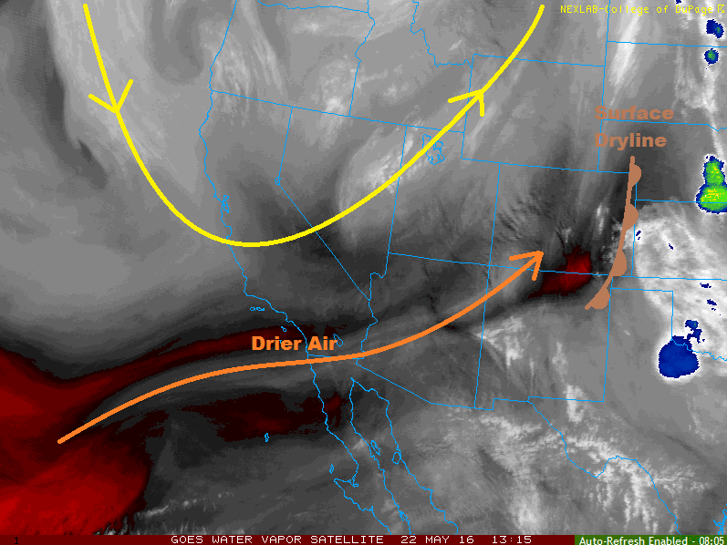
Current analysis shows an upper-level trough laying overtop of the West Coast, while a surface low pressure system develops over SE Colorado/NE New Mexico/SW Kansas/Panhandles. Ejecting from the upper-level trough is a shortwave disturbance, which will move across Colorado later today. The placement of the surface low pressure center is important, as it will help to transport moisture westward into northeastern Colorado, while bringing downlope conditions and drying to much of southeastern Colorado. A Denver Cyclone will also be in play today, providing an additional focus for thunderstorm development.

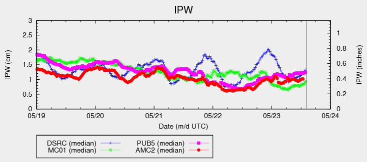
All of the ingredients mentioned above will combine to create the strong-to-severe thunderstorm risk for portions of eastern Colorado. The regions with the highest relative risk of seeing the isolated-to-scattered thunderstorms will be the Front Range, Urban Corridor and Northeast Plains where the moisture/instability will be best. IPW values remain around average for this time of year (see IPW chart below), which will help mitigate the potential flood threat. However, with strong instability and dewpoints in the 40s and 50s, moderate-to-heavy rainfall will attend the strongest storms.

Further to the south across the Palmer Ridge and Southeast Plains (north of Highway 50), slightly drier air will hinder thunderstorm chances, but one or two isolated storms cannot be ruled out. Otherwise, the area will remain mostly sunny and warm, with generally breezy conditions.

IPW_20160524

For the rest of the state, today will be marked by sunshine and warmth, with high temperatures reaching to normal for this time of year. A few fair weather cumulus clouds will dot the higher terrain this afternoon, attended by a few streaks of virga over the Continental Divide. A sprinkle or two may make its way to the surface over the higher terrain of the Northern and Central Mountains regions, but that will be about all the atmosphere can muster. For more information regarding timing, impacts, and rain rates, please see the zone specific forecast discussions below.

Today’s Flood Threat Map

For more information on today’s flood threat, see the map below (hover over threat areas for more details). For Zone-Specific forecasts, jump below the map.

Flood Threat Legend

Zone-Specific Forecasts

Front Range, Urban Corridor, and Northeast Plains:

Isolated-to-scattered strong thunderstorms expected. A few will become severe. The main threats will be large hail and damaging winds, along with a couple tornadoes. Moderate-to-heavy rain will attend the stronger storms, with maximum rain rates as follows:

Front Range: 0.8-1.2 inches/hour
Urban Corridor and Northeast Plains: 1.8-2.2 inches/hour

Storm motions will help mitigate the flood threat somewhat, but a low flood threat is warranted. Street and field ponding will be the main threats, especially combined with hail and locations with poor drainage.

Timing: Noon – 8 PM over the Urban Corridor and Front Range, 2 PM – Midnight over the Northeast Plains

Palmer Ridge, and Southeast Plains:

The threat for isolated thunderstorms is more conditional over these locations, with more needing to go right to get thunderstorms to develop. The better moisture and instability lies to the north of the area, but the shortwave will likely pass just near enough to kick off a thunderstorm or two (along and north of Highway 50). The main threat from any thunderstorm development will be damaging winds and hail (up to 1.25 inches in diameter). Brief moderate rainfall to the tune of 0.4-0.8 inches/hour will be possible. Otherwise, the day will be mostly sunny and breezy.

Timing: 2 PM – 7 PM

Northern Mountains, Central Mountains:

Mostly sunny with high temperatures near seasonal average will be the main weather story today. Afternoon cumulus clouds will develop over the higher terrain, producing mainly virga. A few sprinkles may make it to the surface, but very little rain is expected.

Timing: Noon – 7 PM

Northwest Slope, Grand Valley, Southeast Mountains, Southwest Slope, San Juan Mountains, Raton Ridge, and San Luis Valley:

Mostly sunny and warm, with high temperatures around normal for this time of year. Fair weather cumulus clouds will dot the higher terrain, but overall the day will be marked by abundant sunshine.

FTB 05-23-2016: Cooler Overall, Isolated-to-Widely Scattered Storms

Issue Date: 5/23/2016
Issue Time: 9:20 AM

NO FLOOD THREAT IS FORECAST.

The overreaching factor in today’s weather across the state will be slightly cooler temperatures than yesterday. Most places will remain mostly sunny as dry air aloft continues to be ushered in from the south-southwest, keeping IPW values below average for this time of year (see chart).

IPW_20160523

A jet streak moving overhead today will provide just enough support to produce isolated-to-widely scattered showers/thunderstorms this afternoon and evening over portions of north-central and northeast Colorado. Additionally, the presence of a weak frontal boundary across the Palmer Divide/Southeast Plains regions will provide just enough surface convergence to force isolated thunderstorms this afternoon/evening. For more information on rain rates and impacts, please see the zone-specific discussions below.

Today’s Flood Threat Map

For more information on today’s flood threat, see the map below (hover over threat areas for more details). For Zone-Specific forecasts, jump below the map.

Flood Threat Legend

Zone-Specific Forecasts

Urban Corridor, Northeast Plains, Southeast Plains, and Palmer Ridge:

I’ve grouped these regions together, even though the forcing mechanisms will be different. The end result will be isolated-to-widely scattered thunderstorms, with the best coverage over the Urban Corridor and Northeast Plains. Activity will begin to fire about 10 AM over the mountains, spreading east-northeast over these regions with time. Relatively dry air in the lower levels will keep today’s storms mainly high-based, with the main threats being small hail, gusty winds, lightning, and brief moderate rainfall. A couple storms may reach severe thresholds for straight-line winds (up to 65 mph) and hail (up to 1.25 inches in diameter). Maximum rain rates vary:

Urban Corridor: 0.5-0.8 inches/hour
Northeast Plains: 0.8-1.2 inches/hour
Southeast Plains: 0.4-0.6 inches/hour
Palmer Ridge: 0.3-0.6 inches/hour

Timing: 11 AM – 8 PM for the Urban Corridor and Palmer Ridge, 2 PM – 11 PM for the Northeast Plains and Southeast Plains

Central Mountains, Front Range, and Northern Mountains:

Isolated high-based showers/thunderstorms expected today, producing more wind than rain. Maximum rain rates are 0.2-0.4 inches/hour over the Central and Northern Mountains, 0.4-0.7 inches/hour for the Front Range. Otherwise, temperatures will be a few degrees cooler than the past few days under mostly sunny skies.

Timing: 11 AM – 8 PM

Southeast Mountains, Northwest Slope, Grand Valley, Southwest Slope, San Juan Mountains, Raton Ridge, and San Luis Valley:

Mostly sunny and dry, with high temperatures just a few degrees cooler than the past few days. A few high-based cumulus over the higher terrain of the Northwest Slope and Grand Valley will result from the passing jet streak, accompanied by a few streaks of virga.

FTB 05-22-2016: Plentiful Sunshine, Chance of Isolated Storms

Issue Date: 5/22/2016
Issue Time: 9:35 AM

NO FLOOD THREAT IS FORECAST.

The upper-level low over the Pacific Northwest will shift slowly to the northeast throughout the period, ushering in drier and slightly cooler air into Colorado (see water vapor image below). With the decrease in moisture and temperatures, the atmosphere will remain mostly stable today, and the main weather story today will be the mostly sunny skies. With that said, there will be two main areas that will hold onto isolated shower/thunderstorm chances.

The first area will be over the Central Mountains, Northern Mountains and, to some extent, the Front Range. A narrow band of lifting/cooling aloft will rotate over these regions during the afternoon and evening, allowing for a couple isolated showers/weak thunderstorms to develop. Due to drier air in the lower levels, activity will remain high based, producing more gusty winds than rain (if any, at all). Northern extents of the Urban Corridor may see one or two of these showers/storms move overhead, but the activity will diminish quickly due to the unsupportive environment.

WV_20160522

The second area will be along the dryline that will lay very near the eastern CO border (current location denoted on the water vapor image above). The best moisture and instability will reside just east of the state in Kansas/Nebraska, making today’s threat conditional. If the dryline can remain over far eastern Colorado, a couple isolated strong-to-severe thunderstorms will develop over the far eastern counties. If the dryline pushes east into western KS, then the threat for thunderstorms will be basically eliminated. Either way, any thunderstorm activity will not produce rain rates capable of flash flooding, so no flood threat is warranted.

Today’s Flood Threat Map

For more information on today’s flood threat, see the map below (hover over threat areas for more details). For Zone-Specific forecasts, jump below the map.

Flood Threat Legend

Zone-Specific Forecasts

Northeast Plains and Southeast Plains:

Locations along/near the eastern CO border will hold the chance for a couple isolated thunderstorms to develop this afternoon/evening along the dryline. For areas west of the dryline, it will be warm and sunny. If storms develop in Colorado, they will become strong-to-severe, but move quickly out of the state. No flood threat is warranted, as rain rates will remain too low with the expected storm motions.

Maximum rain rate: 0.8-1.4 inches/hour

Timing: Noon – 9 PM

Central Mountains, Northern Mountains, Front Range and Urban Corridor:

A couple isolated high-based showers/thunderstorms are possible, mainly over the higher terrain. One or two may move over northern extents of the Urban Corridor, but will diminish quickly. Not much rain, if any, is expected from any activity.

Timing: Noon – 8 PM

Palmer Ridge, Raton Ridge, Southeast Mountains, Northwest Slope, Grand Valley, Southwest Slope, San Juan Mountains, and San Luis Valley:

Mostly sunny and dry, with plenty of afternoon warmth. It will be a pleasant late-May day, so be sure to get outside and enjoy it.

FTB 05-21-2016: Mostly Sunny and Warm, with Isolated Thunderstorms

Issue Date: 5/21/2016
Issue Time: 9:05 AM

NO FLOOD THREAT IS FORECAST.

Current analysis shows the upper-level trough/low continues to spin over the West Coast while an upper-level ridge continues to build over the High Plains. This set up will continue to develop/strengthen the leeside trough sitting across eastern Colorado. Meanwhile, a dryline will sharpen across the eastern Plains, effectively delineating the areas that could see isolated thunderstorms across the lower elevations. Over the mountains, a couple isolated, high-based showers/weak thunderstorms will develop mainly along and north of I-70 during the afternoon and evening hours. Not much rain is expected from them.

IPW_20160521

Now, we turn our attention back to eastern Colorado where the strongest thunderstorms are possible today. There will not be much coverage, and will probably only be a couple of thunderstorms. Warming in the mid-levels will effectively cap off the environment from any thunderstorm development west of the dryline. Along/east of the dryline, enough moisture/lift will be present to break the cap in a few places, resulting in isolated strong-to-severe thunderstorms. The main threats will be damaging wind gusts, hail, and lightning. An isolated tornado cannot be ruled out along/near the CO/KS border. Thunderstorm activity will come to an end/move out of the state by 6-8 PM. Please see the zone-specific forecast discussions below for more information regarding maximum rain rates and timing.

Today’s Flood Threat Map

For more information on today’s flood threat, see the map below (hover over threat areas for more details). For Zone-Specific forecasts, jump below the map.

Flood Threat Legend

Zone-Specific Forecasts

Palmer Ridge, Northeast Plains, Raton Ridge, and Southeast Plains:

Isolated strong-to-severe thunderstorms are possible for eastern extents of the regions today, for areas along and east of the dryline. The dryline will likely sit along a line from eastern Weld County, across central Morgan to central Washington County, arcing southward through eastern Lincoln, western Kiowa/Bent Counties and eastern Las Animas County. The main threats will be damaging wind gusts, hail, and lightning, but an isolated tornado cannot be ruled out near the CO/KS border. Brief moderate-to-heavy rainfall is also likely, but storm motions will mitigate the threat of any flash flooding issues. Maximum rain rates will be 1.2-2.0 inches/hour.

West of the dryline, it will be mostly sunny and dry today, with highs ranging from the upper 70s to low 90s.

Timing: 2 PM – 8 PM

Northern Mountains, Front Range and Urban Corridor:

Mostly sunny and warm, with only a couple isolated showers/weak thunderstorms developing over the higher terrain. One or two may drift over the Urban Corridor. The atmosphere will be too dry to produce rain rates capable of flash flooding, and the main impact from any thunderstorm will be gusty winds and lightning.

Timing: 1 PM – 8 PM

Central Mountains, Southeast Mountains, Northwest Slope, Grand Valley, Southwest Slope, San Juan Mountains, and San Luis Valley:

Mostly sunny and warm, with winds being the main weather impact today. Winds will be breezy today, especially across the Northwest Slope, Grand Valley, and Southwest Slope regions. Winds will be out of the southwest at 10-25 mph, gusting to 35-45 mph. A cool front will nudge closer to the area from the west overnight, perhaps producing an isolated shower or two over the Northwest Slope overnight tonight, resulting in very little rain.