Issue Date: Saturday, May 27th, 2017
Issue Time: 9:55AM MDT
— LOW flood threat for Southeast Plains
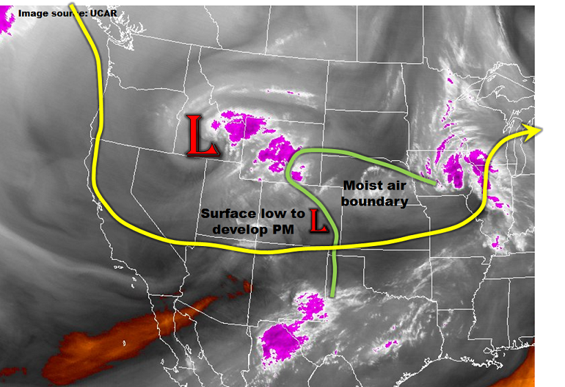
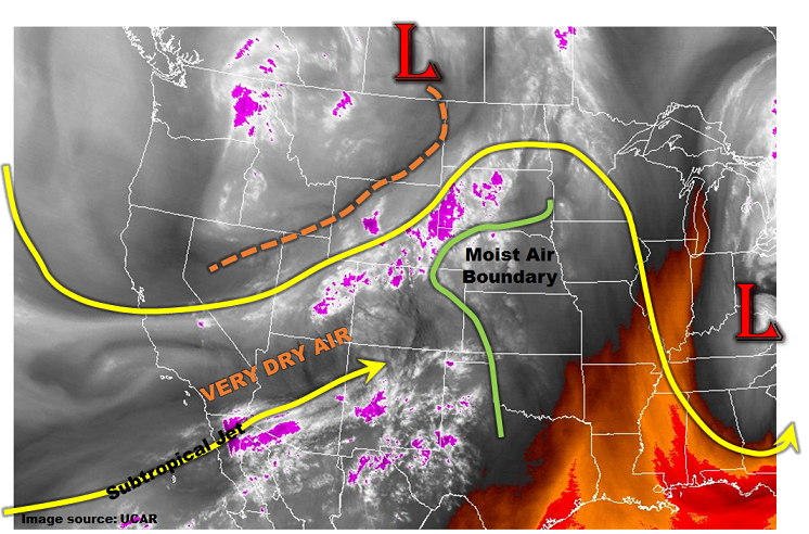
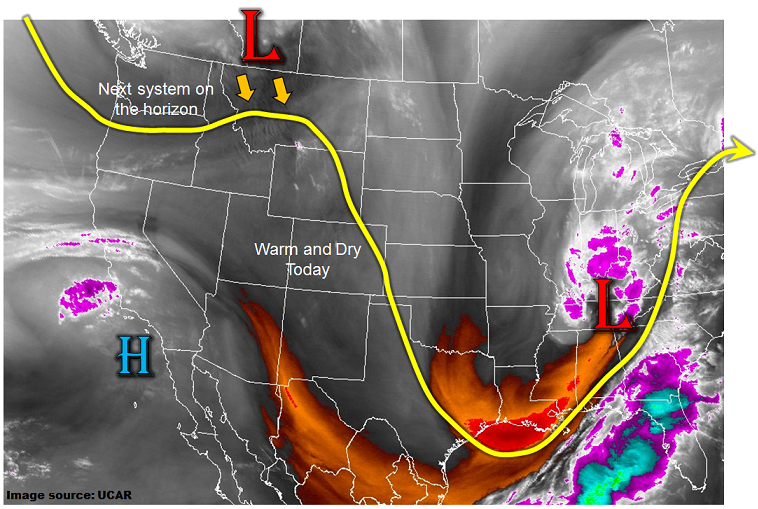
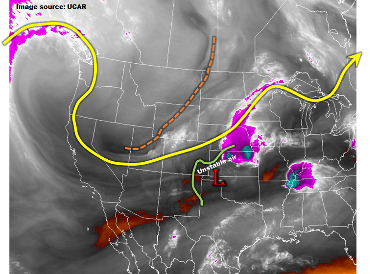
The main disturbance, responsible for the last two days’ worth of severe weather, will be traversing across Colorado today as seen in the water vapor image below. Upward motion will be favored to the east of the trough axis (tan dashed line) and some support will also be available from a weak jet streak moving out of Colorado this afternoon. Thus, scattered to numerous showers are likely to develop this afternoon, especially east of the Continental Divide. A lee-side surface low pressure trough will once again form today, this time along the NM/CO border. This will act to direct moisture northwest into the Southeast Plains and Raton Ridge area. Storm motions in that region will be on the slower side, in the 25-30 mph range, which is conducive for locally heavy rain. The main factor acting against the chances of heavy rainfall will be limited instability, except for the southeast portion of our state. There, up to 1,000 J/kg of CAPE will be briefly available for convective development, with surface dew point temperatures in the low 50s feeding thunderstorm inflows. All in all, expect isolated to scattered thunderstorms in southeast Colorado today with at least isolated heavy rainfall being a good probability. Thus, a Low flood threat is warranted for that area.
In addition to the precipitation, hail up to 1.5 inches, gusty winds up to 55mph and a weak tornado could accompany the stronger cells.
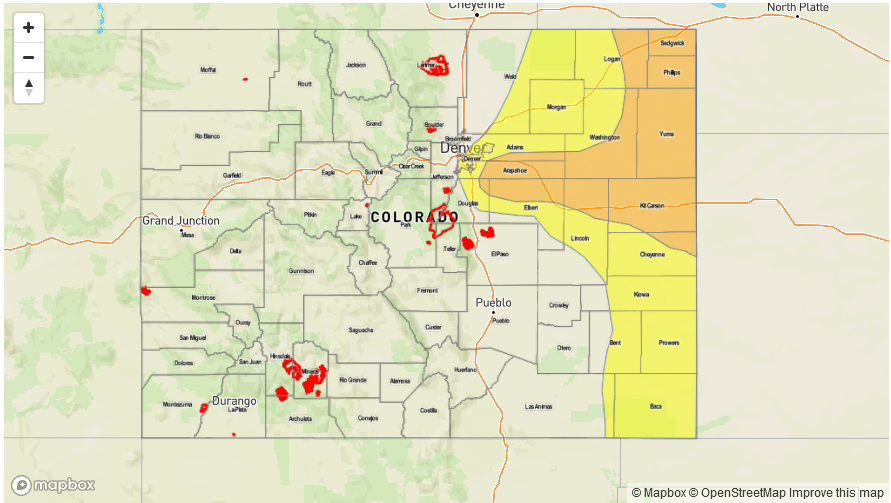
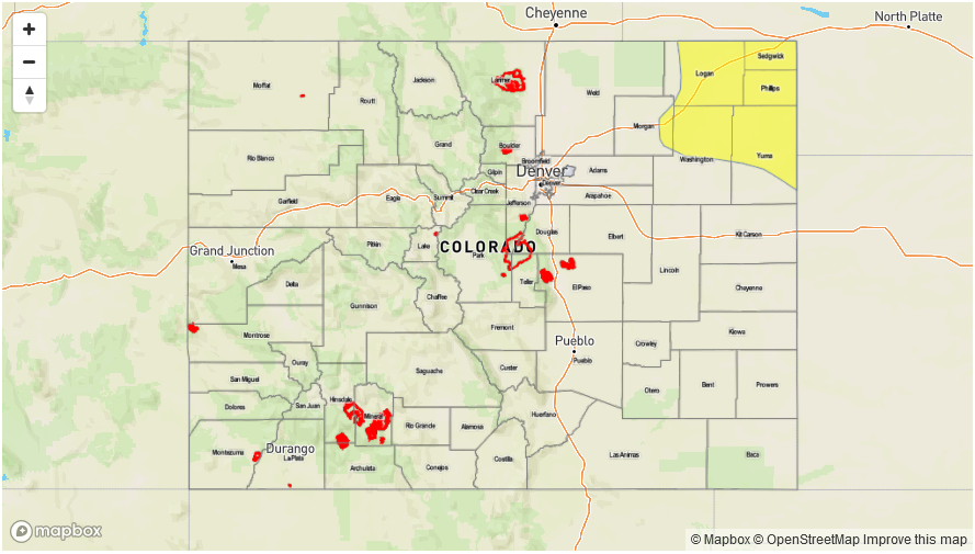
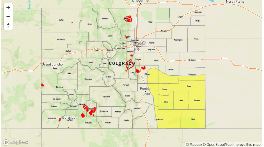
Today’s Flood Threat Map
For more information on today’s flood threat, see the map below (hover over threat areas for more details). For Zone-Specific forecasts, scroll below the map.

Zone-Specific Forecasts:
Raton Ridge, Southeast Mountains, Southeast Plains:
Partly cloudy this morning, then scattered showers and thunderstorms developing by early afternoon. Max 1-hour rainfall up to 1.8 inches will be possible in far southeast areas, with up to 0.7 inches elsewhere. A Low flood threat has been posted for part of the region for isolated flash flooding, as well as field and road flooding. Hail up to 1.5 inches, gusty winds and a weak tornado could accompany the strongest storms.
Primetime: 1PM to 9PM, with a few showers lingering through midnight
Northeast Plains, Front Range, Urban Corridor, Palmer Ridge:
Partly cloudy this morning with showers and a weak thunderstorm developing by early afternoon. Cooler temperatures today with the increased cloud cover. Max 1-hour rain rates up to 0.6 inches possible. Small hail (up to 0.5 inches) could accompany the strongest cells. Flooding is not expected today.
Primetime: 11AM to 7PM
San Juan Mountains, Southwest Slope, Grand Valley, San Luis Valley, Northwest Slope, Northern Mountains, Central Mountains:
Mostly cloudy with scattered rain and higher-elevation snow showers throughout the day, diminishing by early evening. A weak thunderstorm is also possible. Max 1-hour rain rates up to 0.4 inches, with max 24-hour rainfall up to 0.65 inches. Snow level 10,000 feet, lowering to 8,500 feet (especially north of I-70).
Primetime: 11AM to 7PM