Issue Date: Thursday, May 25th, 2017
Issue Time: 10:00AM MDT
— LOW flood threat for portions of Northeast Plains
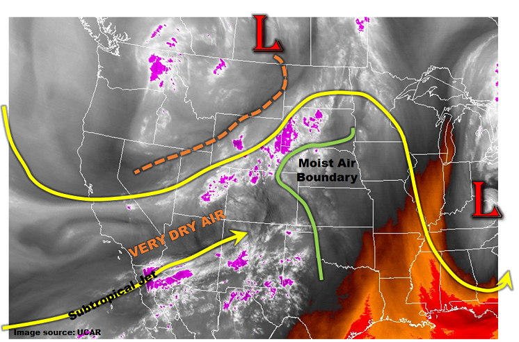
A strong disturbance moved into western North America over the past few days, and will influence our weather beginning today. The water vapor image, below, shows that the main circulation is located in southern Saskatchewan today. Draped to the southwest is a trough axis that extends into the Great Basin. As this disturbance approaches Colorado, it will cause large-scale lift and generate plenty of showers and thunderstorms. West of the Continental Divide, limited instability will keep rain rates below flood-prone intensity. East of the Continental Divide, a pocket of higher moisture exists in northeast CO today. Acting against this is a plume of very dry air being advected from the southwest by a strong subtropical jet. This will limit the heavy rainfall threat to areas along the Nebraska border. Also acting against the flood threat will be very swift storm motions, above 40mph. Nonetheless, a Low flood threat has been issued for parts of the Northeast Plains for isolated flash flooding.
Perhaps the bigger story today will be the potential for severe weather – most notably gusty winds up to 75mph and large hail, up to 1.5 inches. These hazards will occur with the strongest storms. However, overall, expect windy conditions across northern Colorado today as high jet stream speeds get mixed downward into the boundary layer courtesy of solar heating.
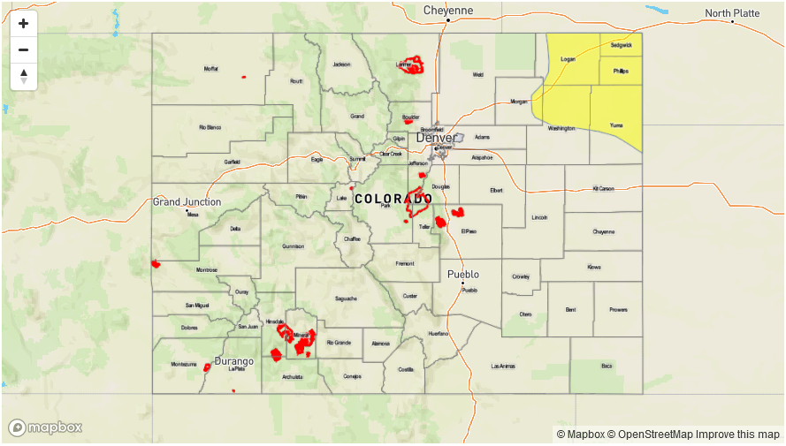
Today’s Flood Threat Map
For more information on today’s flood threat, see the map below (hover over threat areas for more details). For Zone-Specific forecasts, scroll below the map.

Zone-Specific Forecasts:
Northeast Plains, Front Range, Urban Corridor:
Mostly clear this morning then increasing clouds with scattered showers and thunderstorms developing by early afternoon. Early activity will start in the higher elevations, then transition eastward into the plains. Max 1-hour rainfall up to 0.7 inches, except up to 1.6 inches in the Northeast Plains. Hail up to 1.5 inches and gusty winds up to 75 mph will be possible with the strongest storms. Isolated flash flooding will be possible. Field and road flooding will be likely with the heaviest downpours.
Primetime: 2PM to 9PM (across far east)
San Juan Mountains, Southwest Slope, Grand Valley, San Luis Valley, Northwest Slope, Northern Mountains, Central Mountains:
Partly to mostly cloudy skies with scattered showers increasing in coverage. Weak thunderstorms are possible in the afternoon. Max 1-hour rainfall up to 0.4 inches with max 24-hour rainfall up to 0.6 inches. Small hail (less than 0.5 inches) will be possible. Snow level 11,000 feet. Gusty winds up to 60mph are expected in the higher elevations today, especially along mountain passes. Flooding is not expected today.
Primetime: 11AM to 8PM
Southeast Plains, Palmer Ridge, Raton Ridge, Southeast Mountains
Mostly sunny early, then increasing clouds with a few showers and a weak thunderstorm possible in the early afternoon. Max 1-hour rain rates up to 0.4 inches. Small hail will be possible with the strongest storms. Gusty winds up to 50mph will accompany the strongest storms. Flooding is not expected today.
Primetime: 2PM to 7PM