FTB 06-16-2017: Moisture Rebounds, But Only A Bit

Issue Date: Friday, June 16th, 2017
Issue Time: 10:20AM MDT

— Flooding is NOT expected today

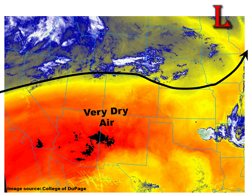
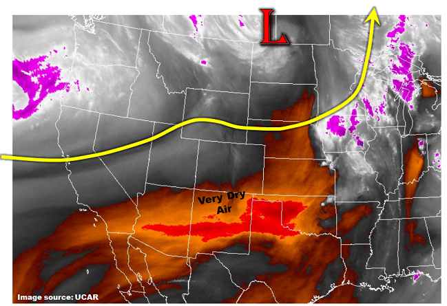
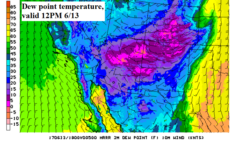
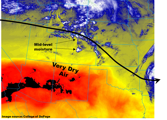
Today’s weather pattern continues to show persistence compared to past days, as a strong jet stream remains positioned just north of Colorado. Over the past 24 hours, moisture has increased across most of the state, with the very dry air being pushed southward into New Mexico. However, most of the moisture increase is in the mid-levels of the atmosphere as can be seen by the mountain wave clouds along the Front Range in the GOES-16 low-level water vapor image below. Near-surface moisture continues to be low, resulting in little to no atmospheric instability once again today.

With plenty of sunshine, a few showers or weak storms cannot be ruled out today, mainly in the northern third of the state. However, steering winds will be strong, above 35 mph thus any rainfall will be short-lived. Thus, flooding is not expected today.

Today’s Flood Threat Map

For more information on today’s flood threat, see the map below (hover over threat areas for more details). For Zone-Specific forecasts, scroll below the map.

Zone-Specific Forecasts:

Northeast Plains, Urban Corridor, Front Range, Palmer Ridge, Raton Ridge, Southeast Mountains, Southeast Plains:

Mostly sunny and warmer again today an isolated shower or storm not out of the question this afternoon. Highest chances are in northern areas towards the Wyoming border. Max 1-hour rainfall up to 0.15 inches. Flooding is not expected today.

Primetime: 1PM to 7PM

Grand Valley, Northwest Slope, Northern Mountains, Central Mountains, Southwest Slope, San Juan Mountains, San Luis Valley:

Mostly sunny and staying warm today with an isolated shower or weak storm possible mainly along the Wyoming border. Max 1-hour rainfall up to 0.2 inches. Flooding is not expected today.

FTB 06-15-2017: Dry Weather Continues, With No End In Sight

Issue Date: Thursday, June 15th, 2017
Issue Time: 10:20AM MDT

— Flooding is NOT expected today

This morning’s weather setup is very similar to Wednesday’s with Colorado being positioned just to the south of a seasonably strong early summer jet stream. In this case, the jet stream is not only separating warmer air to south from colder air to the north, but is also acting as a moisture boundary. Areas to its south are very dry this morning, as seen in the low-level water vapor imagery below from GOES-16. Note that the black colors in NM, AZ and CA are actually off the color scale because of just how dry it is. This morning’s precipitable water (PW) in Flagstaff, AZ was a mere 0.1 inch.

Closer to home, PW values are more in the 0.25 to 0.5 inch range across the state, which is still much below seasonal normal. With plenty of sunshine this morning, expect a quick warm up with some fair weather cumulus clouds likely this afternoon. Areas towards the KS border could see an isolated shower or weak storm, much like Wednesday afternoon. However, nothing that warrants a flood threat.

Today’s Flood Threat Map

For more information on today’s flood threat, see the map below (hover over threat areas for more details). For Zone-Specific forecasts, scroll below the map.

Zone-Specific Forecasts:

Northeast Plains, Urban Corridor, Front Range, Palmer Ridge, Raton Ridge, Southeast Mountains, Southeast Plains:

Mostly sunny and warmer again today an isolated shower or storm not out of the question this afternoon. Highest chances are from the Palmer Divide towards the Kansas border. Max 1-hour rain rates up to 0.25 inches. Flooding is not expected today.

Primetime: 2PM to 8PM

Grand Valley, Northwest Slope, Northern Mountains, Central Mountains, Southwest Slope, San Juan Mountains, San Luis Valley:

Mostly sunny and continued warmer today with high temperatures exceeding 90F for lower elevation valley locations. Flooding is not expected today.

FTB 06-14-2017: Plenty Of Sunshine On Tap

Issue Date: Wednesday, June 14th, 2017
Issue Time: 10:15AM MDT

— Flooding is NOT expected today
— Elevated fire threat for southwest and south-central Colorado

It is a “severe clear” morning across Colorado today, with not a cloud in sight statewide. A dry atmosphere continues to dominate the state, though moisture levels have come up slightly over the past 24 hours. Yet, precipitable water values remain below 0.5 inches or lower. The tail end of yesterday’s upper-level disturbance will continue affect the state today, mainly through some weak mid-level dynamics and cool temperatures aloft. An isolated shower or perhaps even a weak thunderstorm is possible for the northern half of the state, perhaps rewarding a lucky location with a few tenths of an inch of water. However, flooding is not expected today.

An elevated fire danger continues today, this time for southwest and south-central Colorado as relative humidity values are expected to drop below 15% through the afternoon. Fortunately, wind speeds will be lower than on Tuesday, which will at least slow the spread of any fire, should one develop.

Today’s Flood Threat Map

For more information on today’s flood threat, see the map below (hover over threat areas for more details). For Zone-Specific forecasts, scroll below the map.

Zone-Specific Forecasts:

Northeast Plains, Urban Corridor, Front Range, Palmer Ridge, Raton Ridge, Southeast Mountains, Southeast Plains:

Mostly sunny and warmer today an isolated shower or storm not out of the question this afternoon. Highest chances are along the Palmer Divide. Max 1-hour rain rates up to 0.15 inches. Flooding is not expected today.

Primetime: 2PM to 7PM

Grand Valley, Northwest Slope, Northern Mountains, Central Mountains, Southwest Slope, San Juan Mountains, San Luis Valley:

Mostly sunny and warmer today an isolated shower or weak storm not out of the question this afternoon. Highest chances will be over Central and Northern Mountains. Max 1-hour rain rates up to 0.15 inches. Flooding is not expected today. Low relative humidity values will keep an elevated fire danger for the San Luis Valley, Southwest Slope and San Juans.

Primetime: 2PM to 6PM

FTB 06-13-2017: Cooler and Windy Statewide

Issue Date: Tuesday, June 13th, 2017
Issue Time: 8:45AM MDT

— Flooding is NOT expected today
— Elevated fire threat for central and southwest Colorado

With a strong upper-level cut-off low pressure system passing just northwest of Colorado today, the main story will be gusty winds statewide. In addition, low relative humidity values are forecasted this afternoon for parts of southern and central Colorado, as shown by the HRRR forecast below. An elevated fire threat will continue through the day, but shift east compared to yesterday. A Red Flag warning was in place for parts of central Colorado this morning, and stay tuned to local National Weather Service offices for updates.

Most everyone will stay dry today with the possible exception of far northwest Colorado, where a few showers will be possible later in the afternoon. However, flooding is not expected today.

Today’s Flood Threat Map

For more information on today’s flood threat, see the map below (hover over threat areas for more details). For Zone-Specific forecasts, scroll below the map.

Zone-Specific Forecasts:

Northeast Plains, Urban Corridor, Front Range, Palmer Ridge, Raton Ridge, Southeast Mountains, Southeast Plains:

Mostly sunny, windy and cooler today with temperatures topping out near seasonal normal. Winds will gust up to 60mph in the higher elevations and 45mph in the lower elevations as a disturbance moves overhead. This, along with low relative humidity values will contribute to an elevated fire threat mainly for the foothills and higher elevations.

Grand Valley, Northwest Slope, Northern Mountains, Central Mountains, Southwest Slope, San Juan Mountains, San Luis Valley:

Mostly sunny to partly cloudy and cooler today with isolated showers possible in the late afternoon over the Northwest Slope. Max 1-hour rainfall up to 0.15 inches. An elevated fire danger will continue today, mainly for central and southern areas with gusty winds and low relative humidity acting in tandem. Stay tuned to local National Weather Service forecasts for more detailed information regarding fire activity.