Issue Date: Thursday, June 15th, 2017
Issue Time: 10:20AM MDT
— Flooding is NOT expected today
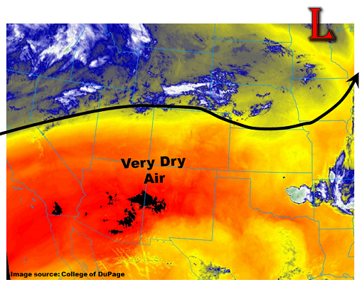
This morning’s weather setup is very similar to Wednesday’s with Colorado being positioned just to the south of a seasonably strong early summer jet stream. In this case, the jet stream is not only separating warmer air to south from colder air to the north, but is also acting as a moisture boundary. Areas to its south are very dry this morning, as seen in the low-level water vapor imagery below from GOES-16. Note that the black colors in NM, AZ and CA are actually off the color scale because of just how dry it is. This morning’s precipitable water (PW) in Flagstaff, AZ was a mere 0.1 inch.
Closer to home, PW values are more in the 0.25 to 0.5 inch range across the state, which is still much below seasonal normal. With plenty of sunshine this morning, expect a quick warm up with some fair weather cumulus clouds likely this afternoon. Areas towards the KS border could see an isolated shower or weak storm, much like Wednesday afternoon. However, nothing that warrants a flood threat.
Today’s Flood Threat Map
For more information on today’s flood threat, see the map below (hover over threat areas for more details). For Zone-Specific forecasts, scroll below the map.

Zone-Specific Forecasts:
Northeast Plains, Urban Corridor, Front Range, Palmer Ridge, Raton Ridge, Southeast Mountains, Southeast Plains:
Mostly sunny and warmer again today an isolated shower or storm not out of the question this afternoon. Highest chances are from the Palmer Divide towards the Kansas border. Max 1-hour rain rates up to 0.25 inches. Flooding is not expected today.
Primetime: 2PM to 8PM
Grand Valley, Northwest Slope, Northern Mountains, Central Mountains, Southwest Slope, San Juan Mountains, San Luis Valley:
Mostly sunny and continued warmer today with high temperatures exceeding 90F for lower elevation valley locations. Flooding is not expected today.