FTB 05-10-2018: More Heat and Dry Weather for Colorado

Issue Date: 5/10/2018
Issue Time: 10:00 AM

NO FLOOD THREAT IS FORECAST TODAY.

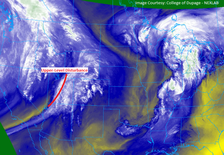
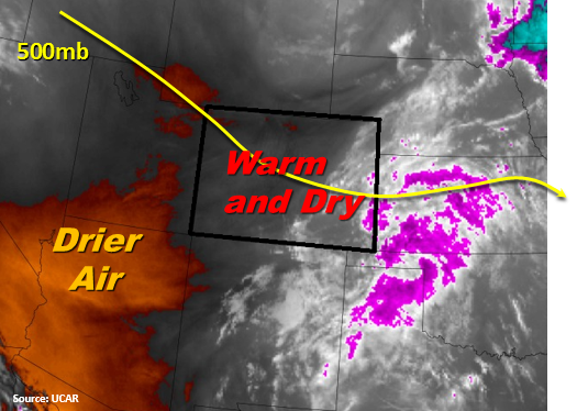
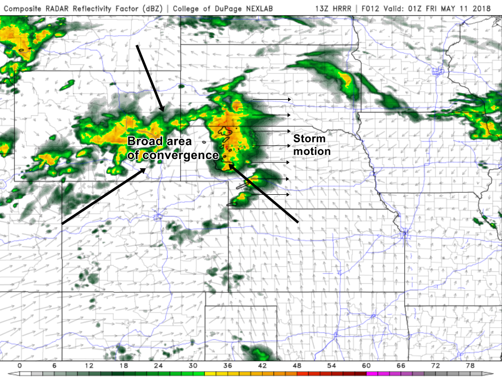
The ridge of high pressure that has parched Colorado over the last few days will continue its slow crawl towards the east, leaving the state once again dry and with above-average temperatures. For today, expect temperatures near or even a bit warmer than they were yesterday. With very little cloud cover across Colorado as the sun rises, and a lack of moisture for clouds to build on, temperatures will be able to increase more steadily compared to yesterday, when there was at least a weak upper level disturbance that was able to keep a good portion of the state with some amount of cloud cover midday to offer respite from the heat. By the afternoon on the Front Range to the eastern plains, there may be enough instability and moisture to work with in the upper levels of the atmosphere to kick off a few stray thunderstorms, but again, with the dry and hot surface conditions there will likely be very little in the way of measurable rainfall. One notable exception is the far northeast part of the state, where some storms could dump a fair amount of rainfall over a short time period. To get substantial rainfall today, you’d need to travel north to Wyoming or Nebraska, where converging winds and better moisture look primed for an afternoon and evening of high thunderstorm activity. An hourly forecast model run by NOAA, known as the High Resolution Rapid Refresh (HRRR) model, is shown below. The image shown is merely an estimate of radar reflectivity for this evening around peak thunderstorm time. Here we see that Colorado, for better or for worse, might be just missing out on the more widespread thunderstorm activity, with only an isolated storm or two expected for the far eastern plains. No flood threat is forecast for today.

Today’s Flood Threat Map

For more information on today’s flood threat, see the map below (hover over threat areas for more details). For Zone-Specific forecasts, jump below the map.

Zone-Specific ForecastsFlood Threat Legend

Front Range, Urban Corridor, Palmer Ridge, Northeast Plains, Southeast Plains, and Raton Ridge:

Arid, summery conditions for today across the entire eastern portions of the state. Much like yesterday, anticipate hot weather and increasing clouds in the afternoon, with the possibility of a few isolated thunderstorms late in the afternoon and into the evening. Don’t expect much in the way of substantial precipitation, however, with gusty winds and lightning being the main sources of hazardous weather. The exception to this is the far eastern and northeastern areas of Colorado, especially in Logan, Sedgwick, and Philips counties, where tonight dew point temperatures might be up into the lower 50’s on top of ambient temperatures in the upper 60’s/lower 70’s at night. This means that with stronger storms a non-negligible amount of rainfall might occur over about a half hour to an hour time span. Under these heavier showers, hourly rainfall rates of 1 to 1.25 inches are possible. While fairly substantial, no flooding is forecast.

Timing for isolated thunderstorms: 3 PM – Midnight
Timing for heavier thunderstorms across the far Northeast Plains: 6 PM – Midnight

Northern Mountains, Northwest Slope, Central Mountains, Grand Valley, San Juan Mountains, Southeast Mountains, San Luis Valley, and Southwest Slope:

Seasonably warm weather will continue to dominate over the mountains and the western slopes today. The majority of this forecast area will enjoy very comfortable weather, with fair weather cumulus and breezy wind in the afternoon hours, and in the high country perhaps a quick shower before the sun begins to set. The only area that has a good chance for precipitation today is up in the northwest, mostly in Moffat County. Here, some showers and storms might begin brewing late in the afternoon and may survive into the evening hours. The lack of good storm dynamics, however, will make it difficult for anything more than a quarter of an inch of rainfall per hour to be observed. The timing of the storms here is from 5pm to Midnight.

FTB 05-09-2018: Weak Disturbance Passing Overhead

Issue Date: 5/9/2018
Issue Time: 9:45 AM

NO FLOOD THREAT IS FORECAST TODAY.

The high-pressure ridge that was in control yesterday will remain in control today, but there’s a new player in today’s forecast. A weak, upper-level disturbance, and associated moisture, (highlighted in the water vapor image below) will push into the state from the west, kicking of isolated showers/thunderstorms as it traverses Colorado. These storms will produce little in the way of rainfall, as low-level moisture continues to lack across much of the state. The exception to this will be across the eastern Plains, along and east of a line from Hereford-to-Brush-to-Kim, where dewpoints in the upper-30s/low-40s will hang on long enough to allow for brief shots of wetting rain underneath isolated thunderstorms. For more details on timing and rain rates, please see the zone-specific forecast discussions below.

Today’s Flood Threat Map

For more information on today’s flood threat, see the map below (hover over threat areas for more details). For Zone-Specific forecasts, jump below the map.

Flood Threat Legend

Zone-Specific Forecasts

Urban Corridor, Palmer Ridge, Northeast Plains, Southeast Plains, and Raton Ridge:

Warm and dry conditions will be the name of the game for most locations today, with only a few isolated thunderstorms rumbling during the afternoon/evening. Low-level moisture continues to lack across the area, so rainfall rates will be limited. The best chance for wetting rains will be east of a line from Hereford-to-Brush-to-Kim where dewpoints in the mid-30s/low-40s will hang on. Generally speaking, the main threat from storms will be gusty winds and lightning, with plenty of virga and only brief periods of rainfall. Maximum rain rates will be 0.05-0.15 inches/hour over the Urban Corridor, Palmer Ridge, and Raton Ridge, with maximum rain rates over the Northeast and Southeast Plains of 0.25-0.5 inches/hour.

Timing: 2 PM – Midnight

Front Range, Northern Mountains, Northwest Slope, Central Mountains, Grand Valley, San Juan Mountains, Southeast Mountains, San Luis Valley, and Southwest Slope:

Increasing clouds and warm temperatures will be the main weather story today, as upper-level moisture streams over the area. A couple isolated, high-based showers and thunderstorms will develop during the afternoon/evening over the higher terrain as the disturbance passes overhead. The main impacts will be plenty of virga, gusty winds, and some lightning, but very little rainfall. Expect nothing more than a sprinkle or two, with the best rain rates that any thunderstorm can produce being 0.05-0.1 inches/hour.

Timing: 11 AM – 10 PM

FTB 05-08-2018: Dry with Above Normal Seasonal Temperatures

Issue Date: Tuesday May 8, 2018
Issue Time: 8:25AM MDT

— Flooding is NOT expected today

The upper disturbance has officially passed through the state, taking with it the high and mid-level clouds from yesterday. There are a few lingering clouds over the eastern plains and Southeast Mountains, but clear skies are expected by midday. Today, the ridge to the west will take hold over the state bringing with it warm temperatures and dry conditions with flow from the northwest. The dry air can be seen in the water vapor imagery below, which will allow for another day of temperatures 10-15F above normal. Little residual moisture remains under the ridge, but there is a slight chance for some light showers over the Northeast Plains as storms fire along the Cheyenne ridge. They are expected to be high-based and dissipate quickly as they move off the higher terrain into the dry air. Flooding is not expected.

Today’s Flood Threat Map

For more information on today’s flood threat, see the map below. For Zone-Specific forecasts, scroll below the map.

Zone-Specific Forecasts:

Palmer Ridge, Front Range, Urban Corridor, Northeast Plains, Southeast Plains, Raton Ridge:

Cloudy this morning over the eastern Plains and Southeast Mountains, but those clouds are expected to clear out by midday. High temperatures this afternoon could reach 80F with highs in the mid to upper 80s over the Southeast Plains. A few showers could wander into the Northeast Plains this afternoon that develop along the Cheyenne Ridge, but they will quickly evaporate in the drier air mass. Accumulation will be isolated, and totals are expected to be under 0.1 inches. Flooding is not expected today.

Primetime: 3PM to 8PM

Northwest Slope, Grand Valley, Southwest Slope, Northern Mountains, San Luis Valley, San Juan Mountains, Southeast Mountains, Central Mountains:

Very warm again today with a few broken clouds over the higher terrains this afternoon. High temperatures in the low valleys will likely reach 80F with highs in the 60-65F range over the mountains. Flooding is not expected today.

FTB 05-07-2018: Cloud Cover Increases with Approaching Upper Trough

Issue Date: Monday, May 7, 2018
Issue Time: 9:00AM MDT

— Flooding is NOT expected today

The ridging pattern present over the past few days begins to briefly break down this afternoon through Tuesday. This upper disturbance will provide lift for some isolated showers over the higher terrains, but only negligible rainfall is expected. The best coverage for high-elevation showers will be over the Central Mountains and southern Front Range. Currently, the visible imagery (below) shows statewide, high cloud cover associated with the approaching trough. The cloud cover will continue to increase through this afternoon and evening as the disturbance moves east to west across the state. More westerly flow over the Front Range and Southeast Mountains will continue to dry out the mid-levels, so any showers that form, will quickly dissipate. Despite the high clouds, high temperatures today will be 10-15F above normal. There is a slight chance for an isolated thunderstorm over the Northeast Plains, where the moisture is able to hold on a bit with more southerly flow. However, dew points in the mid to upper 40s will cause more gusty winds than heavy rainfall. Flooding is not expected.

Today’s Flood Threat Map

For more information on today’s flood threat, see the map below. For Zone-Specific forecasts, scroll below the map.

Zone-Specific Forecasts:

Palmer Ridge, Southeast Mountains, Raton Ridge, Front Range, Central Mountains, Urban Corridor, Northeast Plains, Southeast Plains:

Cloudy this morning with increasing cloudiness this afternoon. An isolated storm over the Northeast Plains is possible this evening, but the main threat will be gusty winds and lightning. 1-hour rain rates up to 0.4 inches are possible under the core of the stronger storms, but only if they are able to break through the cap. Over the high country, rain totals are expected to be under 0.1 inches with the highest coverage over the Central and Front Range Mountains. Flooding is not expected today.

Primetime: 2PM to 10PM

Northwest Slope, Grand Valley, Southwest Slope, Northern Mountains, San Luis Valley, San Juan Mountains:

Very warm again today with upper level clouds increasing through this afternoon and evening. Dry air will limit shower activity to the higher terrains today. Totals are expected to be under 0.1 inches with highest coverage over the northern San Juan Mountains. Flooding is not expected today.

Primetime: 2PM to 8PM