FTB 05-19-2019: The Next Upper-Level Low Approaches

Issue Date: 5/19/2019
Issue Time: 8:55 AM

NO FLOOD THREAT IS FORECAST TODAY.
NOTE: STREAMS AND RIVERS IN THE SAN LUIS VALLEY ARE RUNNING A BIT HIGH TODAY DUE TO SNOW MELT BUT ARE NOT EXPECTED TO REACH FLOODING THRESHOLDS.

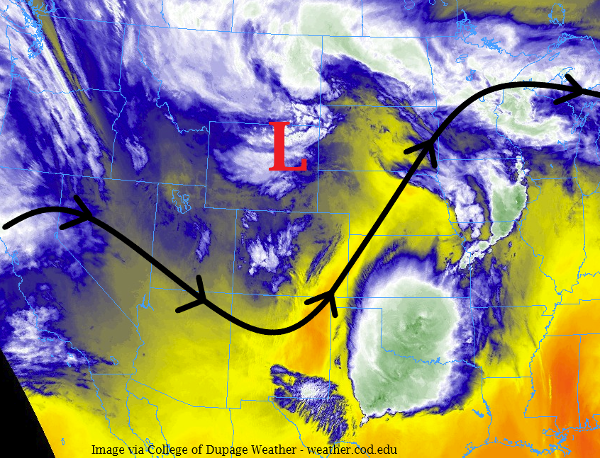
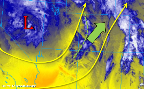
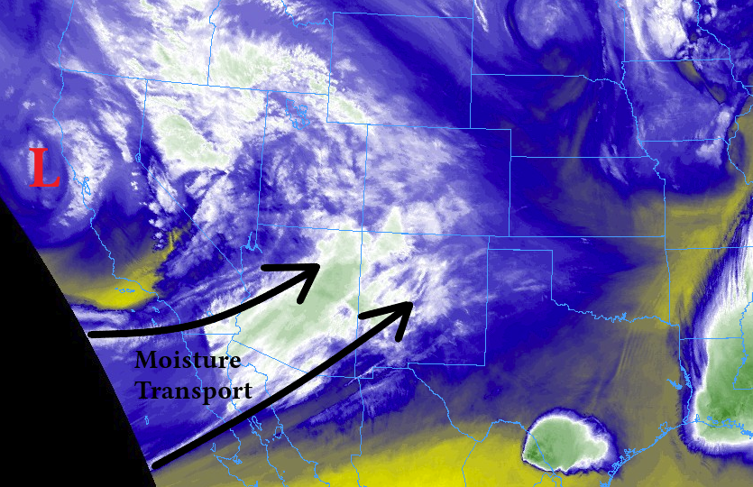
The next upper-level low will approach from the west today, becoming centered over Nevada by midnight tonight. Associated with this upper-level low is an area of broad moisture transport, highlighted in the image below, which will spread mid-level moisture across the state throughout this forecast period. For much of the day today, this southwesterly flow and ribbon of moisture will bring showers and a few thunderstorms to the High Country, spilling over into the valleys as they move towards the northeast. While the best coverage and strongest activity (relatively speaking) is expected during the afternoon and evening, this shower activity will continue overnight and into tomorrow morning.

East of the mountains, the development of a surface low pressure circulation centered near the Palmer Ridge by this afternoon will bring easterly, upslope flow to northeast Colorado. This will result in scattered showers and a few embedded thunderstorms over the Urban Corridor, Northeast Plains, Palmer Ridge, and northern portions of the Southeast Plains during the afternoon and evening. This activity will be garden-variety, with periods of light-to-moderate rainfall, gusty winds, and occasional lightning, with thunderstorms capable of producing small hail.

During the overnight/morning hours tomorrow, a few thunderstorms will develop over the far Southeast Plains due to a moisture surge from the southeast as the aforementioned surface low pressure strengthens in response to the approaching upper-level low. These storms will be capable of producing brief periods of moderate-to-heavy rainfall, hail up to 1.5 inches in diameter, and strong winds up to 60 mph.

For more details on timing and rain rates, please see the zone-specific forecast discussions below.

Today’s Flood Threat Map

For more information on today’s flood threat, see the map below. For Zone-Specific forecasts, jump below the map.

Zone-Specific Forecasts

Urban Corridor, Northeast Plains, Southeast Plains, Palmer Ridge, and Raton Ridge:

Conditions will be dry across much of the area, especially during the morning and early afternoon hours. By 2 PM or so, the aforementioned surface low and easterly, upslope flow will kick off a few showers and embedded thunderstorms over the Urban Corridor, Palmer Ridge, Northeast Plains, and northern portions of the Southeast Plains. This activity will be garden-variety with periods of light-to-moderate rainfall, gusty winds, and occasional lightning, with thunderstorms capable of producing small hail. This activity will diminish slowly after sunset, with a few lingering showers possible into the early morning hours tomorrow. Maximum rain rates from this activity will be 0.1-0.25 inches/hour.

After midnight, a couple thunderstorms will develop over the far Southeast Plains. These storms are expected to be on the strong-to-severe side of the scale, capable of producing brief periods of moderate-to-heavy rainfall, hail up to 1.5 inches in diameter, and strong winds up to 60 mph. Maximum rain rates for this activity will be 1-1.25 inches/hour. These storms are the early precursor to a dangerous severe weather day across Oklahoma, Texas, and Kansas tomorrow.

Front Range, Southeast Mountains, Northern Mountains, Northwest Slope, San Luis Valley, Central Mountains, San Juan Mountains, Grand Valley, and Southwest Slope:

Scattered showers and a couple weak thunderstorms are expected today across the mountains, with activity spilling over valleys with time as storms move towards the northeast. A few showers are ongoing at this time; activity will increase as we move into the afternoon hours, with scattered coverage expected to continue into tomorrow. Snow levels will be around 9000-10000 feet. Most of the activity will produce rainfall rates less than 0.1 inches/hour, with maximum rain rates of 0.15-0.25 inches/hour possible from weak thunderstorms.

Timing: Isolated showers are ongoing, activity will increase after lunch time, and scattered showers and a couple weak thunderstorms will continue through the remainder of the period (11 AM tomorrow).

FTB 05-18-2019: Unsettled Saturday Ahead

Issue Date: 5/18/2019
Issue Time: 8:55 AM

NO FLOOD THREAT IS FORECAST TODAY.

The upper-level trough and corresponding upper-level low pressure center are traversing the Central Rockies today, providing support for another unsettled day across Colorado. Moisture has been reduced as compared to yesterday, and high temperatures will be cooler as well, resulting in an environment lacking the instability to produce thunderstorms capable of heavy rainfall. Instead, the showers and storms today will be more garden-variety, producing snowfall mainly above 9000 feet, light-to-moderate rainfall elsewhere, with gusty outflow winds and occasional lightning.

Most of the activity will be garden-variety, with the exception of a couple strong thunderstorms over the Northeast Plains, Palmer Ridge, and Southeast Plains that will have gusty winds up to 40-50 mph, small hail, and brief moderate rainfall. Activity is expected to come to an end between 9 and 10 PM tonight. For more details on timing and rain rates, please see the zone-specific forecast discussions below.

Today’s Flood Threat Map

For more information on today’s flood threat, see the map below. For Zone-Specific forecasts, jump below the map.

Zone-Specific Forecasts

Urban Corridor, Northeast Plains, Southeast Plains, Palmer Ridge, and Raton Ridge:

Cooler temperatures with scattered showers and thunderstorms are on tap today across the area. Most rainfall rates will be less than 0.2 inches/hour, but a couple stronger storms could produce rainfall rates in the 0.3-0.6 inches/hour range over the Northeast and Southeast Plains. Stronger storms will have the potential to produce wind gusts up to 40-50 mph and small hail.

Timing: 11 AM – 10 PM, with primetime between 2 PM and 8 PM

Front Range, Southeast Mountains, Northern Mountains, Northwest Slope, San Luis Valley, Central Mountains, San Juan Mountains, Grand Valley, and Southwest Slope:

Scattered showers and perhaps a weak thunderstorm or two are expected today, producing light rain and snow showers. Snow levels are expected to be around 8,000 – 9,000 feet, with a trace to 4 inches of accumulation possible over mountain peaks, with a few peaks in the Central Mountains possibly receiving up to 4-8 inches by tomorrow morning. Below 8000 feet, rain rates will be less than 0.2-0.3 inches/hour.

Timing: 11 AM – 9 PM, with the best coverage between Noon and 7 PM.

FTB 05-17-2019: Approaching Trough Returns Scattered Storms and Snow to the Forecast

Issue Date: Friday, May 17th, 2019
Issue Time: 8:45AM MDT

–Flooding is NOT expected today

Currently there is some light to moderate rainfall over western Colorado and with snow being report in Pagosa Springs. These showers are associated with another shortwave that is rounding itself around the base of the trough and some upper air support from the jet. The center of the trough is currently over Nevada and is forecast to move westward today as it becomes an open wave. This should increase rainfall chances from west to east into the afternoon and evening with storms having southwest to northeast movement. For western Colorado, the best chances for measurable rainfall will be along the Continental Divide and Flat Tops. Expect storm activity to continue into mid-afternoon with a break this evening as dry air moves in from Utah (yellow in the image below). However, a surface low is forecast to move into southwest Colorado by early tomorrow morning, so a second set of showers and snow (>8K ft) are likely over SW Colorado to start the day.

With southwest winds aloft, moisture over the southeast quadrant of the state will be minimal due to downsloping effects, so not expecting much rainfall over the Southeast Mountains and not much, if any, over the adjacent Southeast Plains and Raton Ridge. The severe thunderstorm threat will follow the dry line, which should set up well to the east of Colorado. Some better wrap around moisture exists over the Colorado and Nebraska/Wyoming border from a surface low over western Nebraska. So as the current set of storms moves to the northeast, best accumulation will be over the northern Front Range, Urban Corridor and Northeast Plains this afternoon and evening. Enhanced convergence along the Cheyenne Ridge will also help boost 24-hour totals along Colorado’s northern border. As a cold front starts to drop through the state this evening, coverage of thunderstorms may also increase in this area. Upper dynamics will likely help continue light showers over the higher terrains through midnight. Totals today and tonight are expected to remain under flood threat criteria, so there is no flood threat today.

Today’s Flood Threat Map

For more information on today’s flood threat, see the map below. For Zone-Specific forecasts, scroll below the map.

Zone-Specific Forecasts:

Front Range, Northern Mountains, Urban Corridor, Palmer Ridge, Northeast Plains:

Increased cloud cover is likely this afternoon as the storms start to form over the Front Range. With northeast movement of the storms and wrap around moisture from the surface low along the northern border, the best chance for measurable rainfall is over the northern Front Range, Urban Corridor and Northeast Plains. The best chance for a severe thunderstorm is over northern Weld and Logan County, although better dynamics will be located in the panhandle of Nebraska. Max 1-hr rain rates up to 0.5 inches will be possible (east) with 24-hr totals just over 0.5 inches (west). Flooding is not forecast.

Primetime: 12PM to Midnight

Northwest Slope, Grand Valley, Southwest Slope, Central Mountains, San Juan Mountains, San Luis Valley:

Expect ongoing showers through early this afternoon until the dry slot arrives. This should bring a break in precipitation until the next wave moves into southwest Colorado early tomorrow morning. This wave will bring snow to higher elevations (>8K ft) with rain at lower elevations. 24-hour totals up to 0.5 inches are possible over the Central and San Juan Mountains, with the highest accumulations along the Continental Divide and Flat Tops where 24-hour totals could reach 0.8 inches. Flooding is not forecast today.

Primetime: Ongoing to 8AM

Raton Ridge, Southeast Mountains, Southeast Plains:

Not too much moisture over the area with the southwest winds aloft. While some cloud cover and light sprinkles may form over the Southeast Mountains, they should evaporate quickly over the adjacent plains. Some strong surface winds are possible today, and with the low relative humidity, fire danger is slightly elevated. With the spring green up, large scale fire growth should be limited. Gusts up to 35 mph are forecast over the Southeast Plains and Raton Ridge, with some higher gusts over the Southeast Mountains. Best chance for precipitation is over the western Southeast Mountains, where most of the precipitation will fall as snow overnight into tomorrow morning. Flooding is not forecast.

Primetime: 2PM to 8AM

FTB 05-16-2019: Warm Temperatures Continue and an Increase in Cloud Cover is Forecast

Issue Date: Thursday, May 16th, 2019
Issue Time: 8:45AM MDT

–Flooding is NOT expected today

High clouds to start the morning that are associated with the trough that continues to move east. Currently, the ridge that has been controlling our weather the last couple of days has moved into western Nebraska. This means southwesterly flow across the state today and some gusty winds over western Colorado this afternoon. Expecting embedded disturbances in the 500mb flow to help increase afternoon storminess over the mountains. A dry slot (marked in dark orange below) starts to move into western Colorado by this afternoon into this evening. Between that and the southwest motion of the storms today, rainfall should be confined to the eastern portions of the Northern, Central and San Juan Mountains for western Colorado. Some strong gusts are likely again today as the storms develop and evaporate.

A slight increase in moisture with this system and southwest motion means more coverage of storms over the Front Range with activity possibly spilling over into the adjacent and eastern plains. Overall, this system still doesn’t have a lot of moisture with it, so not expecting high accumulations with the high-based thunderstorms. More or less, expect cloudiness to increase throughout the day. The best chance for rainfall occurs early this evening over the Front Range and Northern Mountains, but with quick storm motion and only minimal low level moisture, not expecting any accumulations over 0.25 inches. Some light rainfall may linger until about midnight over the Northeast Plains, but flooding is not forecast.

Today’s Flood Threat Map

For more information on today’s flood threat, see the map below. For Zone-Specific forecasts, scroll below the map.


Zone-Specific Forecasts:

Front Range, Northern Mountains, Urban Corridor, Palmer Ridge, Raton Ridge, Northeast Plains:

Another day with some hot, spring temperatures. Highs could reach 90°F again across the lower elevations. Scattered showers and thunderstorms are expected to pick up again this afternoon over the higher elevations. Without much moisture, expect gusty winds and more cloud cover than accumulation. Isolated, 24-hour totals up to 0.25 inches are possible over the Front Range and Northern Mountains, though the majority of storms will produce less than 0.1 inches or just a few sprinkles. Strong gusts are also possible with the evaporation of storms. Not much thunderstorm activity is forecast over the adjacent and eastern plains either, although there is a slight chance for light rainfall over the Northeast Plains tonight. Flooding is not forecast.

Primetime: 1PM to Midnight

Northwest Slope, Grand Valley, Southeast Mountains, Southwest Slope, Central Mountains, San Juan Mountains, San Luis Valley, Southeast Plains:

Cloud cover will increase throughout the day, but not much accumulation is likely with the storms that develop due to the dry air mass in place. High wind gusts will likely mix to the surface as well under storms. Winds are expected to pick up over the western portion of the state by early afternoon, but no fire danger is expected at this time. The best chance for measurable rainfall will again be along the Divide. Max 1-hr rain rates up to 0.2 inches are possible for storms today, although most totals will be trace amounts or under 0.1 inches. Flooding is not forecast.

Primetime: 2PM to 9PM