Issue Date: Saturday, July, 6th, 2019
Issue Time: 9:40AM MDT
–A MODERATE flood threat is issued for the Spring Creek burn area
–A LOW flood threat is issued for the Northeast Plains, Southeast Plains, Raton Ridge and portions of the Southeast Mountains and Palmer Ridge. This threat includes the Junkins burn area.
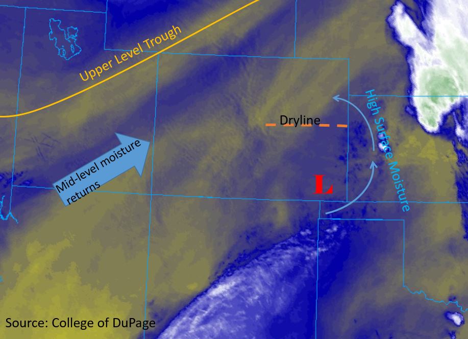
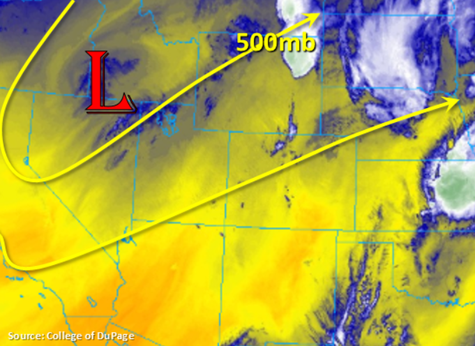
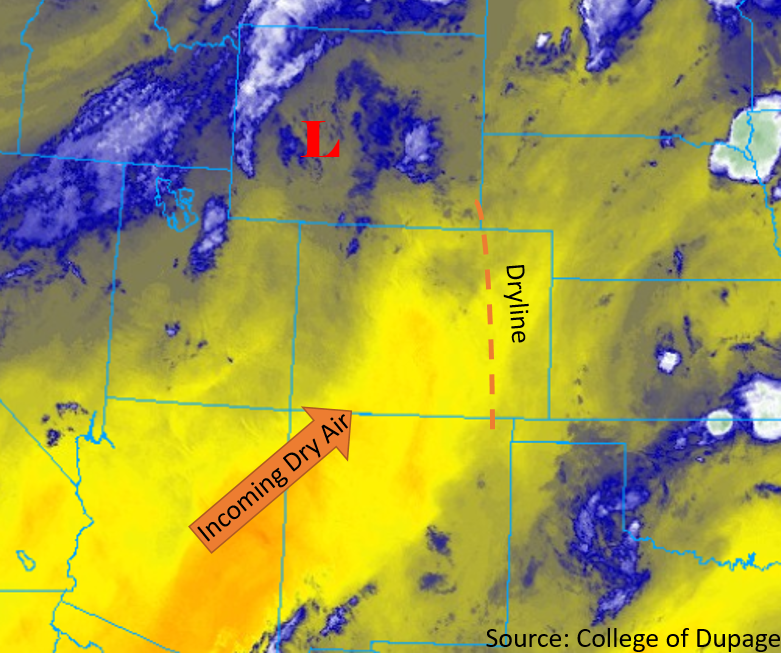
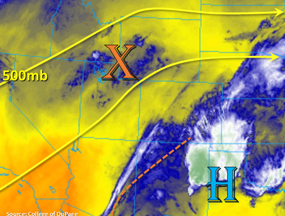
A little bit of cloud cover to start the day over the southern portion of the state and over the eastern plains. Taking a look at the water vapor imagery below, there is quite a bit of moisture over these areas with dew points in the 50°Fs to the east. A weak ridging pattern will be over the state today with a couple shortwaves passing through the flow, which should help produce more widespread coverage of storms and allow storms to survive as they move east off the higher terrains. One shortwave is marked in WY/UT with the orange “X” (from the trough to our west) with other shortwaves forecast to rotate around the high over Mexico/TX into the southern tier of the state (dotted orange line). The synoptic pattern is oriented in a way that it will foster a moisture surge from the south, originating from the Pacific and Gulf of Mexico. This should return moisture to the San Juan and southern Central Mountains for some afternoon thunderstorms. PW at Denver this morning was measured at 0.86 inches with a strong moisture gradient (increasing) towards Dodge City, KS where the sounding measured PW at 1.16 inches. Flow aloft will turn more westerly today, so expecting storms that form over the mountains to spill into the adjacent eastern plains later this afternoon and evening. Without favorable upper level dynamics in place, storms will begin to weaken a couple of hours after sundown and as the shortwaves move out of the state.
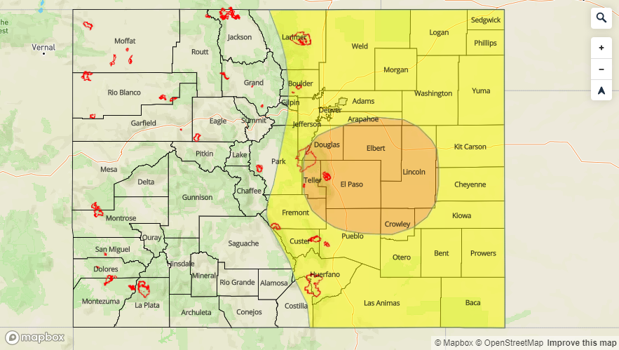
Best coverage of storms today, in the mountains, will be over the Southern Front Range, southern Central Mountains (closer to the Continental Divide), Southeast Mountains/Raton Ridge and San Juan Mountains. Not quite enough moisture for a flood threat to be issued over the 416 burn area, but 2-3 hour totals in the area could reach up 0.5 inches. A Moderate threat has been issued for the Spring Creek burn area with a Low threat for the Junkins burn area. The main threats are flash flooding and debris slides if a storm tracks over the hydrophobic soils. With a high moisture content over the eastern plains, steering winds over the area at 10-15 mph and saturated soils over Cheyenne and Kiowa Counties, a Low flood threat has been issued. The threat includes the Northeast Plains as storms may move into the area from the Cheyenne Ridge. Threats today include flash flooding of creeks and small rivers, arroyo flooding and street/low lying flooding.
Riverine:
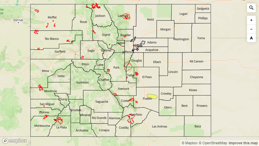
The are currently no NWS Flood Warnings this morning (as of 9:30 AM), although there are plenty of elevated rivers and streams in the high country and across the San Luis Valley. So Minor flooding over lowland areas will be possible for the remainder of this weekend. Please use caution near swift moving water. There is also the possibility of more dam releases, so swollen rivers and creeks downstream of dams are possible and should be monitored closely during recreational activities. Please tune into your local NWS for the latest on Flood Advisories and Warnings, but here are a list of the current Flood Advisories: Frying Pan River below Ruedi Reservoir, Roaring Fork River near Aspen, Blue River below Dillon Reservoir. Additionally, we have had reports of high flows within the SLV along the Conejos and Rio Grande River with Platoro and Terrace Reservoirs looking very full as well. Along the Arkansas River gages at Canon City, Pueblo Dam, Avondale and La Junta are at Action stage. Unless there is a release from Pueblo Dam, these should remain below Minor flood stage today. However, should the heavy rainfall threat be realized over the Raton Ridge, the Purgatoire River will likely increase flows over the Arkansas at the La Junta gage later tonight into tomorrow. With increased chances of rainfall today over the mountains, be prepared for additional rises in elevated rivers and creeks. Again, NWS will update Flood Warnings and Advisories throughout the day, so be sure to follow those closely.
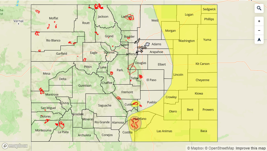
Today’s Flood Threat Map
For more information on today’s flood threat, see the map below. For Zone-Specific forecasts, scroll below the map.

Zone-Specific Forecasts:
Northeast Plains, Palmer Ridge, Front Range, Urban Corridor, Southeast Mountains, Raton Ridge, Southeast Plains:
Increasing storminess for this afternoon with weak thunderstorms forecast for the mountains and adjacent plains. As storms move into the far eastern plains and Raton Ridge area, increased moisture and slow steering winds will produce heavy rainfall, large hail (up to 1.75 inches) and gusty outflow winds. Max 1-hour rain rates up to 0.75 inches will be possible over the mountains and Urban Corridor due to slightly faster steering winds. Hail may also be possible with some gusty winds, similar to the last couple of days. Max 1-hour rain rates increase to 1.25 inches over the Raton Ridge and Southeast Plains. Over the Northeast Plains, if storms track in from the Cheyenne Ridge, 1-hour rain rates up to 1.75 inches will be possible. A Low flood threat has been issued with a Moderate threat for the Spring Creek burn area. 1-hour rain rates up to 0.75 inches could cause flash flooding, mud flows and debris slides if a storm tracks over these burn areas. A second set of storms form over the Southeast Mountains tonight during the early evening (passing shortwave), but storms will likely dissipate as they move into the adjacent plains.
Primetime: 12PM to 2AM
Northwest Slope, Grand Valley, Southwest Slope, Northern Mountains, Central Mountains, San Juan Mountains, San Luis Valley:
A surge of moisture from the south will bring back thunderstorms and showers to the San Juan and south central Mountains for today with most activity this afternoon and early evening. A couple showers may persist near the Continental Divide through 10PM. Not a ton of moisture in place, but with the additional lift from shortwaves, storms will be more scattered than isolated. Max 1-hour rain rates up to 0.4 inches will be possible with most storms producing between 0.10 and 0.25 inches. Gusty winds will be also be likely along with small hail. There may even be some light showers over the SLV with the lighter rain totals mentioned above. Elsewhere clear and warm conditions will continue. Flooding is not forecast, though trailing storms over the 416 burn area should be monitored closely.
Primetime: 11AM to 10PM