Issue Date: Wednesday, July 3, 2019
Issue Time: 10:50 AM MDT
– A LOW flood threat is issued for the Eagle River near Gypsum and the Arkansas River near Avondale
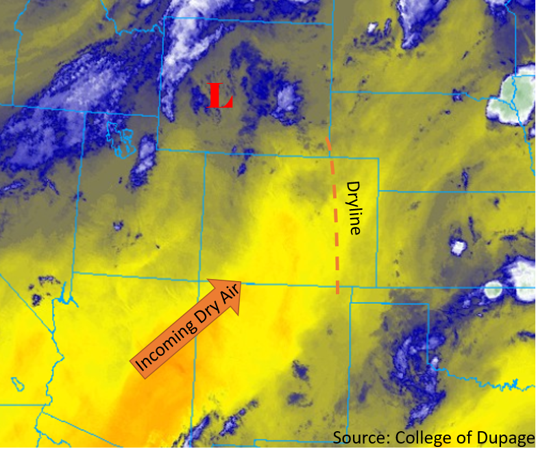
The weather pattern today is very similar to yesterday, but drying of the atmosphere is expected reduce storm coverage this afternoon. Upper level flow remains out of the west/southwest, with a trough to the west and ridge to the southeast. The difference from yesterday is that today the flow is advecting only marginal moisture in the midlevels and hot, dry air in the low levels (yellow in the water vapor imagery below). This has reduced the PW values statewide with the sounding at Denver this morning dropping to 0.65 inches. A shortwave and surface low are expected to form in south-central Wyoming this afternoon (marked with “L”), which will cause a statewide southerly and southwesterly wind shift at the surface. The surface winds will pull in warm and dry air from the south and southwest, which will help increase temperatures by a few degrees from yesterday’s values. Clear skies and downslope flow off of the mountains this morning will heat up and dry out the surrounding plains and low laying areas, which will reduce storm coverage this afternoon. While surface moisture on the eastern plains this morning is high, this is not expected to last as mixing of this surface moisture to the east will form a dryline (orange line) by early afternoon. With only minimal residual moisture left over the state, chances for precipitation are lower across the state. Diurnal flow will initiate some weak thunderstorms and showers along the Continental Divide and eastern foothills, which are anticipated to move over the adjacent plains by 2PM. With storms today producing gusty winds, outflow boundaries may provide some extra convergence for additional high based storms over the eastern plains. The main threat from rainfall today will be gusty winds up to 45 mph small hail and moderate rain rates over the eastern plains. Flooding is not forecast from rainfall.
Riverine:
The riverine flood threat continues today as flows remain elevated across the high country and San Luis Valley from melting, rainfall and dam releases. The Flood Warning continues for Eagle River near Gypsum, which is bankfull at the moment. There was also another dam release at Pueblo Dam, so flows at Avondale will remain elevated throughout the day. The La Junta gage is also forecast to stay at Action stage. A Low flood threat has been issued for La Junta with Minor lowland flooding as the main threat. There are also several Flood Advisories in place with some minor flood reports to accompany them: Frying Pan below Ruedi Reservoir, Roaring Fork near Aspen, Gore Creek at Vail, Eagle River at Red Cliff, Crystal River near Redstone, Los Pinos River in eastern La Plata County, Blue River below Dillon, Colorado River in RMNP and downstream of Grand Lake. The Conejos River in Conejos County is also experiencing very high water with flooding reported in various locations within the area. AHPS gages are also showing the Rio Grande running high, so there is likely some minor flooding in low lying areas for this river as well. On top of that, high country reservoirs are running full, so be prepared for releases from dams throughout the next couple of days, which could cause Minor flooding issues and swollen rivers downstream of the dams. Please tune into your NWS office for the latest on Warnings and Advisories as these will be updated throughout the day. You can also follow some of the flooding here: AHPS gages. While river flows are forecast to decrease into the holiday weekend, fast moving water and bankfull conditions will continue to make banks unstable. Please use extra caution around the high, fast moving water this weekend.
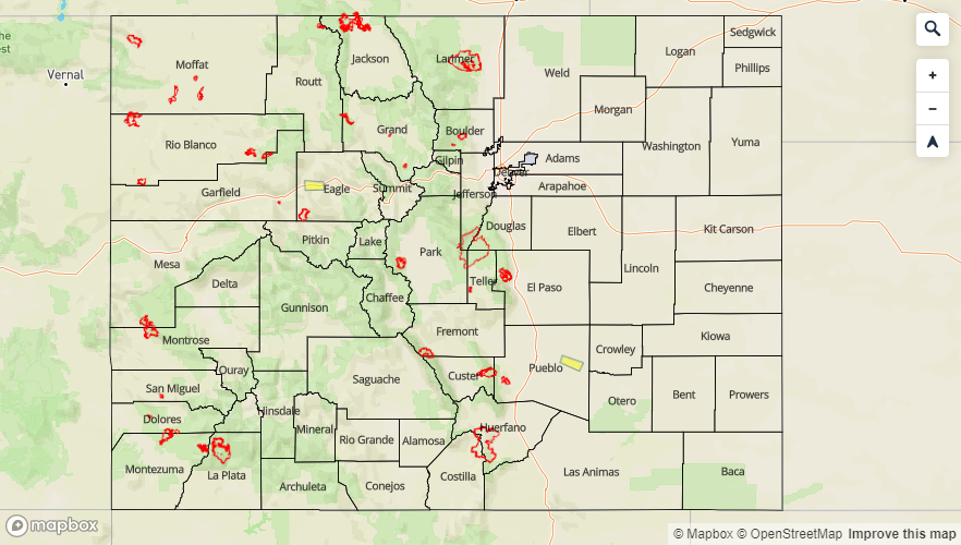
Today’s Flood Threat Map
For more information on today’s flood threat, see the map below. For Zone-Specific forecasts, scroll below the map.

Zone-Specific Forecasts:
Front Range, Northern Mountains, Urban Corridor, Southeast Mountains, San Juan Mountains, San Luis Valley, Raton Ridge:
Diurnal upslope flow will provide chances for afternoon thunderstorms and showers this afternoon though coverage of storms will decrease. A shortwave passing through Wyoming will provide additional lift to the northern areas of the Front Range and Urban Corridor, so storms will be more numerous over this area. Limited moisture and warm temperatures throughout the area will keep storms high based, with virga and gusty winds (up to 40mph) as the main threat. Max 1-hour rainfall rates up to 0.25 inches are forecast. No flood threat has been forecast in the area today, but high elevation rivers remain near bankfull throughout the area, which will make banks unstable.
Primetime: 12PM to 8PM
Northeast Plains, Palmer Ridge, Southeast Plains:
There is a chance of precipitation this afternoon as storms move off the Palmer Ridge and Front Range Mountains into the adjacent plains. a dryline sets up over the eastern plains, so once storms move to the east of this feature, expect rain rates to increase.. Temperatures will increase rapidly throughout the morning and into the afternoon, with highs jumping back into the 90°Fs over the area. Max 1-hour rain rates of 0.75 inches are forecast for the Northeast Plains and Palmer Ridge. Storms off of the Raton Ridge may drift over the Southeast Plains, but max 1-hour rain rates of only 0.4 inches are forecast along the southern border with most activity dissipating as they move off the higher terrain. The main storm threat again will be wind gusts up to 45 mph and moderate rainfall rates. Due to dam releases and extra runoff from the last couple days of rain, a Low flood threat is issued for lowland areas along the Arkansas River near Avondale.
Primetime: 1PM to 11PM
Southwest Slope, Grand Valley, Northwest Slope, Central Mountains:
Dry, warm air brought in from the southwest will keep chances for precipitation very low today. A weak storm may form along the Continental Divide in the Central and Northern Mountains, but totals should remain under 0.1 inches. Dew points will decrease into the 20°Fs and 30°Fs by midday with temperatures forecast to be in the upper 80F°s over the western slope, 90°Fs in Grand Valley. Temperatures in the high country will get into the 70°Fs and low 80°Fs. Increased surface winds are forecast for the Northwest Slope from the approaching trough, so a Red Flag Warning is in place through 8PM tonight and then again tomorrow. Surface winds are forecast to be in the 20-25 mph range with gusts up to 35 mph. Please use caution with open flames when camping this weekend and any activity that could cause a spark. Lastly, for riverine flooding, snowmelt will continue today. With many streams and rivers running near or above bankfull, Minor lowland flooding is possible. A Low flood threat is issued for the Eagle River near Gypsum in Eagle County, which is under a NWS Flood Warning.