FTB 08-11-2019: Severe Thunderstorms Forecast for the Northeast Plains along with Very Heavy Rainfall

Issue Date: Sunday, August 11th, 2019
Issue Time: 9:10AM MDT

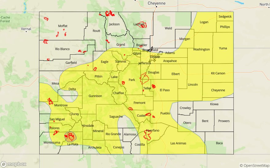
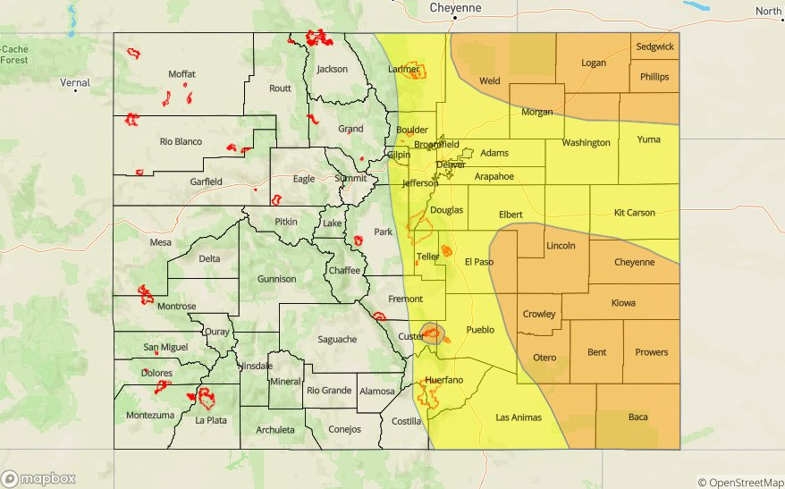
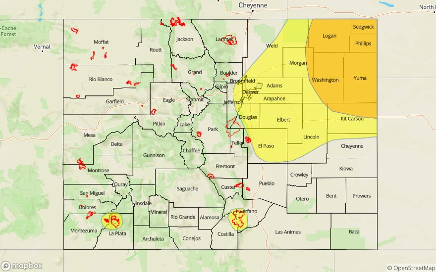
— A MODERATE flood threat has been issued for the Northeast Plains
— A LOW flood threat has been issued for the southern Urban Corridor, Palmer Ridge, 416 burn area and the Spring Creek burn area

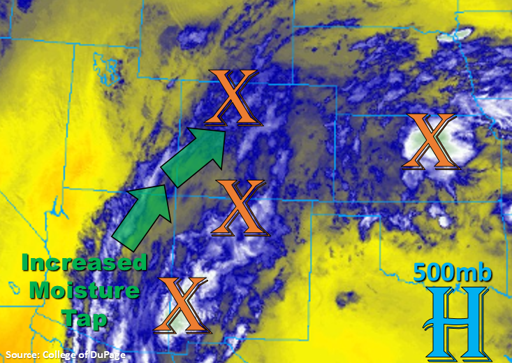
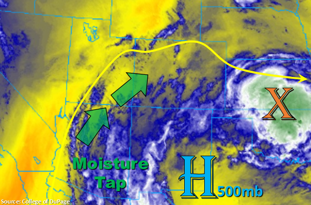
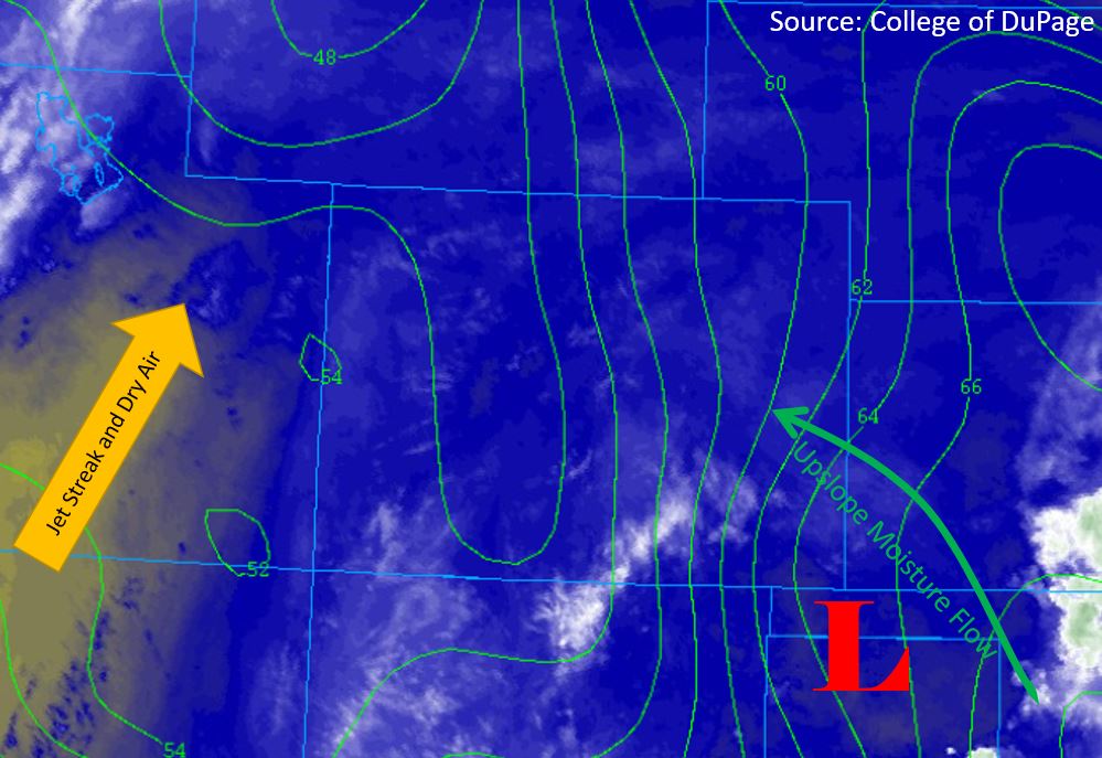
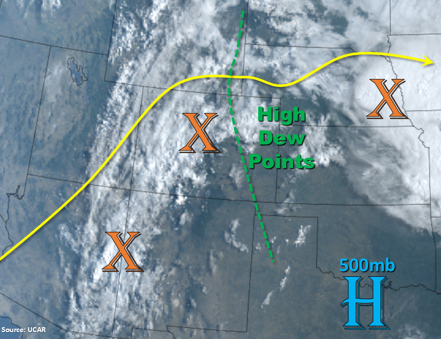
The active weather pattern will continue to round out the weekend with the 500mb high remaining in a favorable position for a northward moisture surge. Marked in the visible satellite imagery below (orange X’s) are the shortwaves, which are expected to help enhance today’s rainfall. The one currently over the state is helping create moderate rainfall over the SW high terrains. To our east is a larger shortwave that passed overhead yesterday, which helped cause some heavy rainfall overnight in Kansas. Today, the Pacific trough will begin to move to the east throughout the day (to our north). This will start to pull in the dry air seen in Utah (cloud free) over western Colorado by this evening with more westerly flow aloft forecast. Southwest flow is forecast east of the Continental Divide as the 500mb only moves slightly eastward from the approaching trough. High moisture is marked in the green line below and denotes where dew points are 60°F or greater. This high moisture is helping produce some thick fog over the northwest corner of the state as well. While some of this moisture will mix out west to east, high PW values will remain over the Northeast Plains. Paired with a decrease in steering winds over this area, storms will be capable of producing very heavy rainfall.

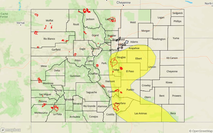
More widespread storms over the mountains with higher rain rates are forecast as morning heating occurs. There should be good coverage of storms, associated with the shortwave, by 11AM to noon. By about 2PM these storms will move into the Urban Corridor and eventually the Northeast Plains. Increased instability and shear over the Northeast Plains should create a couple severe thunderstorms (large hail, strong winds and possible isolated tornado) and an eventual N-S oriented line of storms. More scattered storms are anticipated over the southern high terrains this afternoon with a storm or two possible over the adjacent plains. The most likely region to receive rainfall over the adjacent plains from these storms is the climatological hot region, the Palmer Ridge.

All storms should exit into Kansas and Nebraska by 10PM or so, but a couple late night showers may be possible over the Southeast Mountains. These would be fueled by a moisture rich environment and the next shortwave moving around the ridge and into the southern tier of Colorado. A Moderate flood threat has been issued for the Northeast Plains and a Low threat has been issued for 416 and Spring Creek burn area, since storms in the area will be able to produce rain rates that have been known to cause flooding issues.

Today’s Flood Threat Map

For more information on today’s flood threat, see the map below. For Zone-Specific forecasts, scroll below the map.

Flood Threat Legend


Zone-Specific Forecasts:

Front Range, Southeast Mountains, Urban Corridor, Palmer Ridge, Raton Ridge, Northeast Plains, Southeast Plains:

Max 1-hour rain rates up to 0.5 inches (northern mountains) and 0.8 inches (southern mountains) will be possible. Over the adjacent plains, trailing storms may cause totals up to 1 inch by tomorrow morning. Max 1-hour rain rates up to 2.25 inches will be possible over the Northeast Plains (Moderate threat area) with isolated storm totals around 3 inches possible by tomorrow morning. Threats include local stream and creek flash flooding, field ponding and road flooding. A couple of severe thunderstorms will be possible with large hail, damaging winds and an isolated tornado. The flood threat should decrease after midnight or a little before. With trailing storms capable of producing such high rain rates over the Southeast Mountains, a Low threat has been issued for the Spring Creek burn area.

Primetime: 11AM to Midnight

Northwest Slope, Grand Valley, Southwest Slope, Northern Mountains, Central Mountains, San Juan Mountains, San Luis Valley:

High moisture holds on over the San Juan and south Central Mountains for one more day. Storms will widespread in coverage, since dry air won’t move into the state from the west until late tonight. Current showers and thunderstorms will likely limit instability for stronger storms this afternoon, but 1-hour rain rates up to 0.6 inches will be possible. With rain falling near the 416 burn area the last couple of days and rain rates greater than 0.4 inches possible, a Low flood threat has been issued for this scar. The threat for mud flows, debris slides and flash flooding over the burn area should end by 10PM. The San Luis Valley will also likely get some rain again with isolated totals up to 0.75 inches by morning with more widespread max 1-hour rain rates closer to 0.5 inches.

Primetime: 11AM to 10PM

FTB 08-10-2019: Rinse and Repeat Pattern with More Widespread Thunderstorm Activity and Overnight Rainfall for the Mountains

Issue Date: Saturday, August 10th, 2019
Issue Time: 9:12AM MDT

— A MODERATE flood threat has been issued for the 416 burn area
— A LOW flood threat has been issued for the San Juan Mountains, Central Mountains, Southeast Mountains, southern Front Range, southern Urban Corridor, Palmer Ridge, Raton Ridge, Northeast Plains and portions of the Grand Valley and Southwest Slope. This includes the following burn areas: Junkins, Hayden Pass, Spring Creek and Lake Christine. This includes the following burn areas: Junkins, Hayden Pass, Spring Creek and Lake Christine.

Similar set up to yesterday with the moisture tap still in place. The subtropical high is currently over Texas, so this feature has shifted a little bit more to the east. In turn, high moisture has re-worked its way back into western Colorado. Shortwaves continue to work across the state as they round the high moving to the NNW. The shortwave that brought late night showers to the high terrains is still moving north, so some isolated thunder and light rain is currently occurring over the Northern Front Range the adjacent Urban Corridor. Today and tomorrow, more pronounced shortwaves will work their way into the state from New Mexico and Arizona. With PW still near an inch at Denver and 0.86 inches at Grand Junction this morning, expecting widespread rainfall throughout the day with some thunderstorms later this afternoon. Moisture will increase throughout the day as well, so heavy rainfall will be possible with the storms today.

Storms are anticipated to kick off around noon over the higher elevations with help from the approaching shortwave. Storm motion will be fairly quick, but with the moisture rich environment, storms will still be capable of producing some impressive rain rates in a 30-45 minute span. Note, that as the storms move into the eastern plains they will gain a more westerly steering component. Another flooding issue will be multiple storms tracking over the same area, which if this happens, will cause an increase in accumulations over the mountains or adjacent plains. Therefore, special attention should be paid to the Palmer Ridge area this afternoon as it has been pounded by rainfall the last couple of days. This means soils are saturated and primed for increased runoff and flash flooding. It may only take a quick 0.5 inches in 30 minutes or less. A few severe thunderstorms are likely over the far eastern Plains as storms make their way into the high CAPE and decent, but low, shear environment. Large hail (1 to 1.25 inches) and brief strong wind (gusts 40 – 50 mph) will be possible with these storms. An additional set severe thunderstorms, capable of very heavy rainfall are anticipated to set up along a dry line, but guidance is showing the heaviest rainfall to our east, over Kansas.

Lastly, there are also flooding concerns over recent burn areas. Please use caution if storms track over any recent burn area as flash flooding, debris slides and mud flows are possible. We have included the 416 burn area in the threat area today due to heavy rainfall from yesterday making the burn scar more susceptible to flooding issues. Additional showers and weak thunderstorms are possible overnight in the southwest mountains with the next passing shortwave, which would affect this burn area. Rain rates should be gradual enough they won’t cause many other issues, but storms may linger over one area for a bit. Thus, the Low flood threat.

Today’s Flood Threat Map

For more information on today’s flood threat, see the map below. For Zone-Specific forecasts, scroll below the map.

Flood Threat Legend


Zone-Specific Forecasts:

Front Range, Southeast Mountains, Urban Corridor, Palmer Ridge, Raton Ridge, Northeast Plains, Southeast Plains:

Widespread showers and thunderstorms anticipated today favoring the Front Range and northern Southeast Mountains. Max 1-hour rain rates up to 0.75 inches (north) and 0.6 inches (south) will be possible. As storms move into the adjacent plains, the best moisture will be along the Palmer Ridge and over the Northeast Plains. Storm totals will be close to 1 inch (west) and up to 1.75 inches to the east near the CO/NE/KS borders. Slightly lower totals are anticipated over the far northeast corner associated with the passing shortwave, which will begin around 11AM. Some isolated severe thunderstorms may also be possible along the dry line over the far Southeast Plains. Max 1-hour rain rates up to 1 inch may be possible. This area lies in the Low flood threat, which includes the Junkins, Hayden Pass and Spring Creek burn areas. Threats today include flash flooding of local streams/creeks, lowland flooding of roads/ditches and field ponding. Additionally, mud flows and debris slides may be especially possible over the Spring Creek burn area. A few storms may linger over the Southeast Mountains overnight, which may affect the Spring Creek burn area.

Primetime: Noon to 5AM

Northwest Slope, Grand Valley, Southwest Slope, Northern Mountains, Central Mountains, San Juan Mountains, San Luis Valley:

Storms this afternoon should be mostly confined to the high terrains over and along the Continental Divide. Very isolated max 2-3 hour totals (trailing storms) up to 0.75 inches will be possible. The higher terrains of the adjacent plains may see up to 0.5 inches in isolated pockets as well, but most storms will produce around 0.3 inches. Another set of storms with more coverage moves into the San Juan and Central Mountains between 10PM and midnight. This could cause (isolated) storm totals between 1 and 1.25 inches by morning with more general totals near 0.75 inches. The most likely locations of the heavier rainfall is forecast over the San Juan Mountains and southeast corner of the Central Mountains. The 416 burn area has a Moderate threat issued because of this and a lot of rainfall near/over the scar yesterday. The Lake Christine burn area is also included in the Low threat, although the higher totals will likely be to the east of the area.

Primetime: 12PM through Morning

FTB 08-09-2019: Moisture Tap Continues with Mid-Level Energy Enhancing Storm Coverage over Southern Colorado

Issue Date: Friday, August 9th, 2019
Issue Time: 9:05AM MDT

— A LOW flood threat has been issued for the Palmer Ridge, Raton Ridge and portions of the southern Front Range/Urban Corridor and Southeast Mountains. This includes the Junkins and Spring Creek burn areas.

The moisture tap continues with the 500mb high over New Mexico and Texas. This feature will continue to be pushed a little more to the east today. The slight easterly movement of the high is due to the dirty ridge pattern (shortwaves passing through the ridge axis), which has caused PW values to drop off when compared to yesterday due to a drier air mass being advected into the state from the WSW. However, PW still remains elevated over eastern Colorado with the Denver sounding measuring 1.06 inches this morning. To the west, PW is closer to climatology (0.8 inches) and will continue to steadily decline. It is likely this afternoon that there will be a slight increase or no change in PW values over the southwest corner due to approaching shortwaves. Further to the north, the dry air will continue to works its way into the state and downsloping winds over the eastern high terrains are expected to limit the chances for afternoon showers and thunderstorms. A pool of moisture looks to remain over the Palmer Ridge, so this should be the area with the highest rainfall potential in the adjacent plains.

Shortwaves rotating around the high from Arizona and New Mexico are forecast to help spark more numerous weak thunderstorms and rainfall this afternoon over the southern portion of the state in tandem with upslope flow (both east and west). Steering winds look to be similar to yesterday (15-20 mph or faster), so the quick moving storms should limit the amount of rainfall over one area. However, a few areas may see some trailing storms, which would increase totals for the day. Since there is higher moisture, enhanced lift over southeastern Colorado and storms tracking over areas that received a lot of rainfall yesterday, a Low flood threat has been issued as storms may produce a quick half inch in 30 minutes. Other storm threats include small hail under the more hefty thunderstorms and strong outflow winds, which in turn, may act to initiate more convection.

As far as burn areas, fast steering winds will limit the threat over the Hayden Pass area. Due to a lot of rain over the Junkins burn area yesterday, it is included in the Low threat. The largest flood threat is over the Spring Creek burn scar just due to its freshness, so the Low has been extended back to the west to cover this. Overall, flood threats today include flash flooding of local streams/creeks, mud flows and debris slides (steeper terrains) and road flooding in low-lying areas. A few storms may linger over the southwest high terrains overnight, but the flood threat should end by midnight.

Today’s Flood Threat Map

For more information on today’s flood threat, see the map below. For Zone-Specific forecasts, scroll below the map.

Flood Threat Legend


Zone-Specific Forecasts:

Northwest Slope, Grand Valley, Southwest Slope, Northern Mountains, Central Mountains, San Juan Mountains, San Luis Valley:

With the best moisture to the south, expecting the most coverage of storms over the San Juan Mountains and south Central Mountains. Max 1-hr rain rates up to 0.4 inches will be possible over the higher terrains with a isolated totals up to 0.6 inches by tomorrow morning (eastern San Juans/Hinsdale County area). A couple storms may end up producing measurable rainfall over the San Luis Valley with the highest totals nearing 0.25 inches around the edges of the valley. Over the northern high terrains (Northwest Slope, Grand Valley, Northern Mountains), storm totals are expected remain below 0.1 inches, and storms are expected be more scattered in nature. Some overnight lingering rainfall may be possible over the San Juan Mountains, but the flood threat should decrease after 11PM.

Primetime: 2PM to Morning

Front Range, Southeast Mountains, Urban Corridor, Palmer Ridge, Raton Ridge, Northeast Plains, Southeast Plains:

Looks like the best chance for rain today will be over the southern half of the high terrains as well as the Raton Ridge and Palmer Ridge. Storm coverage will also decrease from yesterday. Not sure any of the thunderstorms will be able to make it much past Las Animas before the instability drops off, but if they do, max 1-hour rain rates up to 1.5 inches will be possible. Back to the west over the southeast and southern Front Range, max 1-hour rain rates up to 0.4 inches will be possible. Thus, there is a Low threat for the Spring Creek burn area. Storms over the Palmer Ridge may produce 1 hour rain rates up to 1 inch. Rain over saturated soils from yesterday’s rainfall may cause some minor flooding issues such as field ponding, street flooding and local stream/creek flash flooding with the increased runoff. The threat should end by about 11PM with no upper dynamics to keep storms going throughout the night.

Primetime: 2PM to 11PM


FTB 08-08-2019: Heavy Rainfall Threat Returns with Severe Thunderstorms Expected over Eastern Colorado

Issue Date: Thursday, August 8th, 2019
Issue Time: 10:15AM MDT

A MODERATE flood threat has been issued over portions of the Northeast Plains, Southeast Plains, Raton Ridge and Palmer Ridge. This includes the Junkins burn area.

-A LOW flood threat has been issued for the Front Range, Urban Corridor, Northeast Plains and the Spring Creek burn area.

PM update (3PM): An additional MODERATE flood threat has now been issued over the Northeast Plains.  Dew points over the area have been steadily increasing from this morning, resulting in higher instability and increasing rain rates.  Another round of storms are expected to move in off of the Cheyenne Ridge this evening, and we have increasing confidence that storms should produce 1-hour rain rates around 1.75 inches.  Isolated storm totals due to multiple rounds of rainfall are forecast to be just over 2.5 inches.  The threat over this area will end after midnight.

Another round of widespread thunderstorms is expected today across the eastern plains. Surface moisture is high throughout the state again with dew points (green contours below) measuring in the 50°Fs and 60°Fs over the western valleys and eastern plains respectively. PW values this morning at Denver were measured at 1.17 inches and should continue to increase throughout the day, which is very high for this time of year. The subtropical high is now centered over south-central New Mexico, which will create westerly steering flow aloft over our area.  A jet streak, which can be seen in the yellow shading of the mid-level water vapor imagery below, will bring in dry air and fast winds to the west today. This should mix out a lot of the mid-level moisture seen in today’s Grand Junction sounding. This feature will also help to keep storms moving and keep rain rates below flood threat criteria.  A vorticity maximum is forecast to form in the lee of the Rockies over southern Wyoming this afternoon, which will provide forcing for widespread severe thunderstorms over the adjacent and far eastern plains. In the moisture rich environment, all storms that form today will be capable of heavy rainfall, thus the large Low threat area.

Morning cloud cover over the northern mountain ranges and portions of the eastern plains will help retain surface moisture this morning. Surface winds from the east and southeast should keep low level moisture from mixing out as well. The surface low pressure system centered over the Oklahoma Panhandle (marked “L”) below will help drive these low level winds.

Storms are forecast to begin over the Continental Divide by mid-day and move over the adjacent plains early this afternoon. Slow upper level steering flows from the northwest between 10 and 15 mph will allow storms to produce heavy rainfall over a 1-2 hour period. Storms will likely be crossing the I-25 interstate around rush hour, so please use extra caution as water will likely pool with the heavy rainfall this afternoon. As the storms move east, a few severe thunderstorms will be possible as indicated by the skinny CAPE profile in the Denver sounding this morning. Threats further to the west include wind gusts in excess of 60mph and hail between 1.75 and 2 inches (isolated). Rain rates will also increase as storms slow down and enter dew points in the 60°Fs to the east. Thus, there is a Moderate flood threat issued, which is anticipated to last until 4AM tomorrow morning.

Today’s Flood Threat Map

For more information on today’s flood threat, see the map below. For Zone-Specific forecasts, scroll below the map.

Flood Threat Legend

Zone-Specific Forecasts:

Front Range, Urban Corridor, Southeast Mountains, Raton Ridge, Palmer Ridge, Northeast Plains, Southeast Plains:

Cloud cover over the mountains has limited instability, which will confine max 1-hour rain rates over the northern Front Range and northern Urban Corridor to 0.75 inches. Over the foothills of the southern Front Range and southern Urban Corridor max 1-hour rainfall rates up to 1 inch are possible. The southeast mountains will have weak downsloping winds and faster upper level winds, which will keep max 1-hour rainfall rates around 0.4 inches. If a storm tracks over the Spring Creek burn area, there may be some flash flooding issues, so the Low flood threat has been pulled over this area. Due to the more eastern location of the Wet Mountains, higher dew points will be likely, so a Moderate flood threat has been issued over the Junkins burn area. Threats over the recent burn areas (if a storm tracks over them) include flash flooding of small rivers and streams, debris slides and mud flows. The National Weather Service has issued a Flash Flood Watch over the eastern mountains to the south of Teller County, as well as El Paso, Pueblo and eastern Las Animas Counties.

Over the Northeast Plains, a Low flood threat has been issued with more isolated max 1-hour rainfall rates up to 1.5 inches possible. Looks like multiple rounds of rainfall (including overnight rain) could create isolated storm totals up to 2.25 inches by morning. Further south, max 1-hour rainfall rates up to 2 inches are possible over the Southeast Plains, with up to 1.75 inches possible over the eastern Palmer Ridge. Due to slow steering winds mentioned above, isolated 2-3 hour storm totals up to 2.75 inches are possible by morning. Threats today include local stream/creek flash flooding, field ponding, street flooding and arroyo flash flooding. This is an overnight Moderate threat with the heavy rainfall ending by 4AM.

Primetime: 11AM to 4AM

Northwest Slope, Northern Mountains, Grand Valley, Southwest Slope, Central Mountains, San Juan Mountains, San Luis Valley:

Westerly dry air and fast wind speeds will keep rainfall below threat criteria today. Chances for precipitation are high over the higher terrain favoring the southeastern San Juan Mountains and the Roan Cliffs/Flat Top region. Max 1-hour rainfall rates to 0.8 inches will be possible over these areas with other storms producing closer to 0.25 inches. There are some isolated storms possible over the San Luis Valley, but totals will likely remain below 0.10 inches.

Primetime: 11AM to 6PM