Issue Date: Friday, August 9th, 2019
Issue Time: 9:05AM MDT
— A LOW flood threat has been issued for the Palmer Ridge, Raton Ridge and portions of the southern Front Range/Urban Corridor and Southeast Mountains. This includes the Junkins and Spring Creek burn areas.
The moisture tap continues with the 500mb high over New Mexico and Texas. This feature will continue to be pushed a little more to the east today. The slight easterly movement of the high is due to the dirty ridge pattern (shortwaves passing through the ridge axis), which has caused PW values to drop off when compared to yesterday due to a drier air mass being advected into the state from the WSW. However, PW still remains elevated over eastern Colorado with the Denver sounding measuring 1.06 inches this morning. To the west, PW is closer to climatology (0.8 inches) and will continue to steadily decline. It is likely this afternoon that there will be a slight increase or no change in PW values over the southwest corner due to approaching shortwaves. Further to the north, the dry air will continue to works its way into the state and downsloping winds over the eastern high terrains are expected to limit the chances for afternoon showers and thunderstorms. A pool of moisture looks to remain over the Palmer Ridge, so this should be the area with the highest rainfall potential in the adjacent plains.
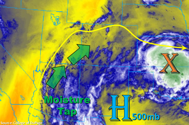
Shortwaves rotating around the high from Arizona and New Mexico are forecast to help spark more numerous weak thunderstorms and rainfall this afternoon over the southern portion of the state in tandem with upslope flow (both east and west). Steering winds look to be similar to yesterday (15-20 mph or faster), so the quick moving storms should limit the amount of rainfall over one area. However, a few areas may see some trailing storms, which would increase totals for the day. Since there is higher moisture, enhanced lift over southeastern Colorado and storms tracking over areas that received a lot of rainfall yesterday, a Low flood threat has been issued as storms may produce a quick half inch in 30 minutes. Other storm threats include small hail under the more hefty thunderstorms and strong outflow winds, which in turn, may act to initiate more convection.
As far as burn areas, fast steering winds will limit the threat over the Hayden Pass area. Due to a lot of rain over the Junkins burn area yesterday, it is included in the Low threat. The largest flood threat is over the Spring Creek burn scar just due to its freshness, so the Low has been extended back to the west to cover this. Overall, flood threats today include flash flooding of local streams/creeks, mud flows and debris slides (steeper terrains) and road flooding in low-lying areas. A few storms may linger over the southwest high terrains overnight, but the flood threat should end by midnight.
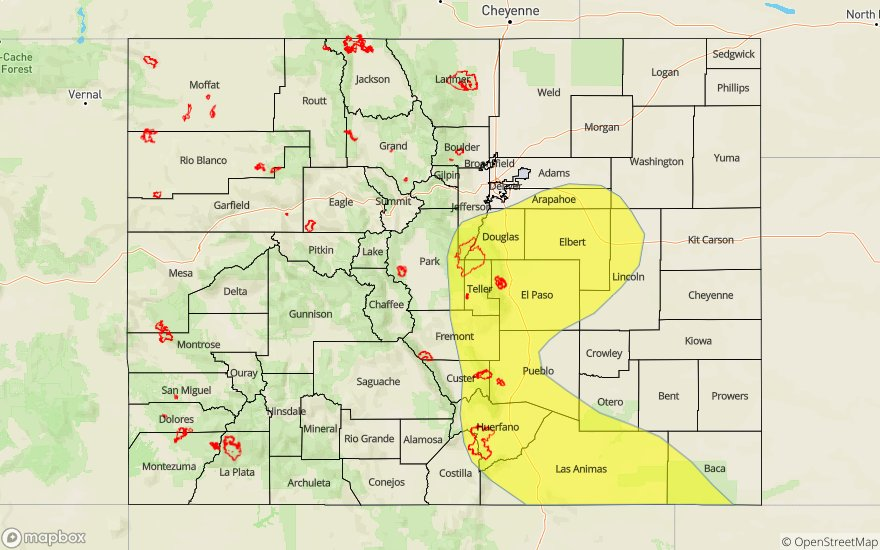
Today’s Flood Threat Map
For more information on today’s flood threat, see the map below. For Zone-Specific forecasts, scroll below the map.

Zone-Specific Forecasts:
Northwest Slope, Grand Valley, Southwest Slope, Northern Mountains, Central Mountains, San Juan Mountains, San Luis Valley:
With the best moisture to the south, expecting the most coverage of storms over the San Juan Mountains and south Central Mountains. Max 1-hr rain rates up to 0.4 inches will be possible over the higher terrains with a isolated totals up to 0.6 inches by tomorrow morning (eastern San Juans/Hinsdale County area). A couple storms may end up producing measurable rainfall over the San Luis Valley with the highest totals nearing 0.25 inches around the edges of the valley. Over the northern high terrains (Northwest Slope, Grand Valley, Northern Mountains), storm totals are expected remain below 0.1 inches, and storms are expected be more scattered in nature. Some overnight lingering rainfall may be possible over the San Juan Mountains, but the flood threat should decrease after 11PM.
Primetime: 2PM to Morning
Front Range, Southeast Mountains, Urban Corridor, Palmer Ridge, Raton Ridge, Northeast Plains, Southeast Plains:
Looks like the best chance for rain today will be over the southern half of the high terrains as well as the Raton Ridge and Palmer Ridge. Storm coverage will also decrease from yesterday. Not sure any of the thunderstorms will be able to make it much past Las Animas before the instability drops off, but if they do, max 1-hour rain rates up to 1.5 inches will be possible. Back to the west over the southeast and southern Front Range, max 1-hour rain rates up to 0.4 inches will be possible. Thus, there is a Low threat for the Spring Creek burn area. Storms over the Palmer Ridge may produce 1 hour rain rates up to 1 inch. Rain over saturated soils from yesterday’s rainfall may cause some minor flooding issues such as field ponding, street flooding and local stream/creek flash flooding with the increased runoff. The threat should end by about 11PM with no upper dynamics to keep storms going throughout the night.
Primetime: 2PM to 11PM