Issue Date: Thursday, May 21, 2020
Issue Time: 11AM MDT
— A LOW flood threat has been issued for the Southeast Plains
—Afternoon update possible today
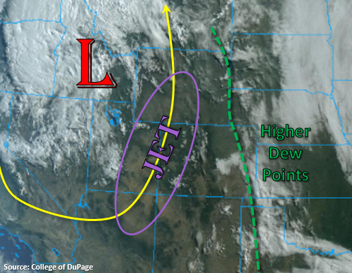
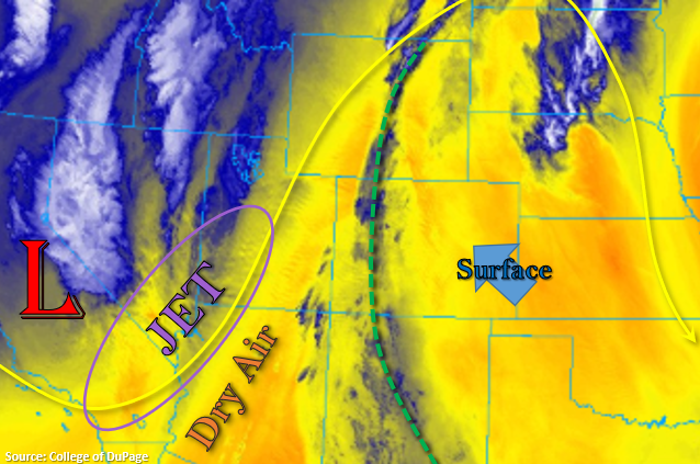
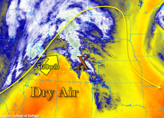
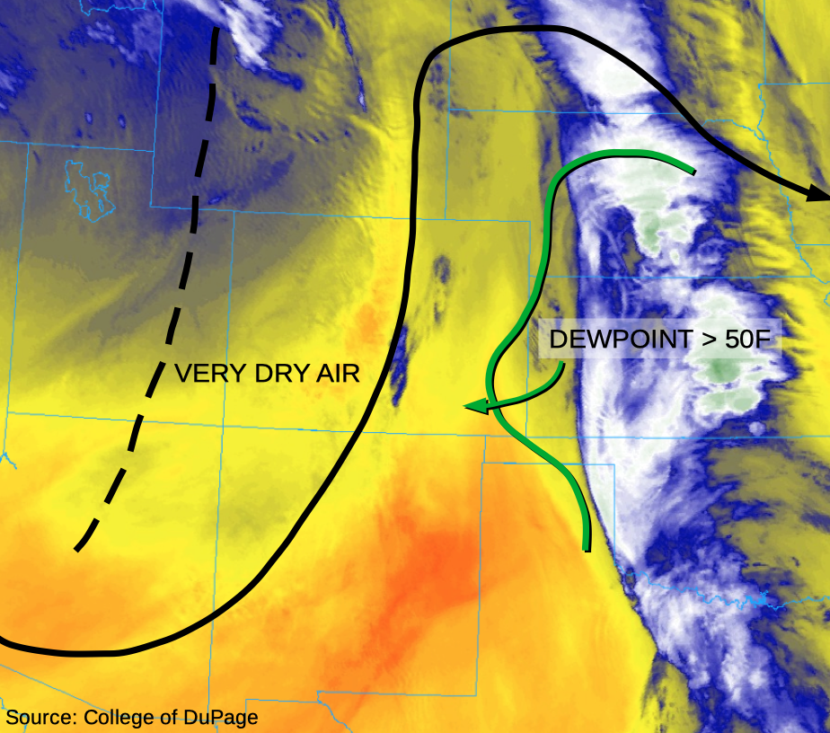
As shown in this morning’s water vapor image below, a large-scale trough is continuing to move eastward across Colorado. Significant drying has occurred over the last 24 hours. For example, this morning’s Precipitable Water (PW) from the Denver and Grand Junction radiosonde balloons is 0.28 inches and 0.24 inches. However, deeper moisture is not very far away, with PW above 1 inch just across the border into Nebraska and Kansas. With very cold upper-level temperatures today, it will not take much heating and surface moisture to initiate isolated storm activity across the Palmer Ridge during the early afternoon. This activity will be benign, with perhaps some light showers possible along with gusty downdraft winds.
Of more concern is storm activity expected to develop along the aforementioned moisture boundary across the Southeast Plains. Although most of the activity will remain in Kansas, there is enough confidence that a mesoscale-to-synoptic outflow boundary from the Kansas convection will propagate into Colorado, carrying with it significant instability (CAPEs > 2000 J/Kg). With relative weak storm-scale steering wind, there is the potential for prolonged redevelopment of activity over the same areas. Thus, a Low flood threat has been issued for eastern parts of the Southeast Plains. Activity could persist well into the overnight hours, supporting the threat of isolated street and field flooding along with flooding of smaller creeks and streams. Favorable shear profile forecasts support large hail in earlier storms, up to 2 inches in diameter.
Although more uncertain, it is possible that the moist outflow boundary will make it as far west as the Wet Mountains west of Pueblo during the overnight hours. This would be unusual from a climatological perspective, but high-resolution guidance suggests that if this were to occur, heavy rainfall, capable of flooding, would be possible. Thus, an afternoon update is possible today to address this risk.
Elsewhere, significant cooling will occur today, which will somewhat reduce the threat of wildfire initiation and spread.
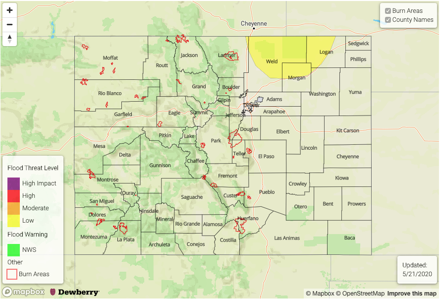
Today’s Flood Threat Map
For more information on today’s flood threat, see the map below. If there is a threat, hover over the threat areas for more details, and click on burn areas to learn more about them. For Zone-Specific forecasts, scroll below the threat map.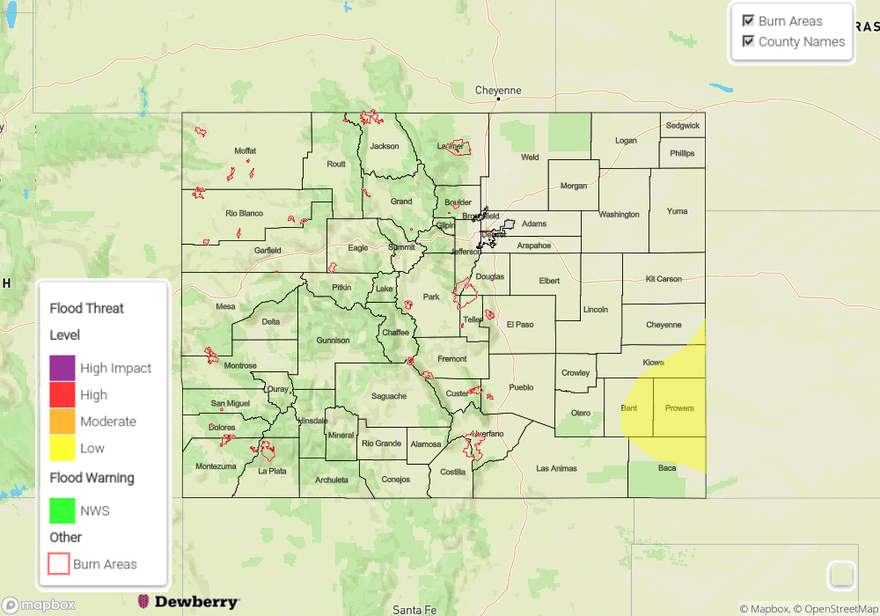
Zone-Specific Forecasts:
Northern Mountains, Front Range, Urban Corridor, Northeast Plains, Southeast Plains, Grand Valley, Northwest Slope, Southwest Slope, San Juan Mountains, Central Mountains, Southeast Mountains:
Mostly sunny, much cooler and drier today with temperatures up to 15F cooler than Wednesday. Isolated thunderstorms are possible over the Front Range and Urban Corridor in the afternoon. However, only very light rainfall is expected along with gusty winds. Flooding is not expected.
Palmer Ridge, Raton Ridge, Southeast Plains:
Mostly sunny early then scattered thunderstorms developing over far southeast areas. Max 1-hour rainfall up to 2.25 inches, with max 3-hour rainfall up to 3 inches possible. A Low flood threat has been issued for parts of the Southeast Plains for isolated street and field flooding. Large hail may accompany the earlier storms. Primetime is 5PM to 3AM.
An afternoon update may be possible to address possible overnight storm concern in areas farther west.