Issue Date: Monday, May 18th, 2020
Issue Time: 8:30AM MDT
— Flooding is NOT expected today
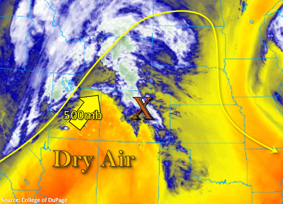
It’s going to feel like a hot summer day with high temperatures generally 15F above normal! This is due to the strong, amplified ridging pattern in place. This pattern will continue to pull in an arid air mass from the southwest, which will keep Colorado rain free this afternoon and help increase fire danger. A weak disturbance is marked with the orange “X” below, and it is helping provide some morning cloud cover. Most of this moisture will mix out as the feature moves eastward throughout the morning, and behind the feature, the dry air will fill in. There may be enough residual moisture left for a high-based rain shower or two over the eastern Raton Ridge. However, don’t expect more than a light sprinkle.
Today’s Flood Threat Map
For more information on today’s flood threat, see the map below. If there is a threat, hover over the threat areas for more details, and click on burn areas to learn more about them. For Zone-Specific forecasts, scroll below the threat map.

Zone-Specific Forecasts:
Front Range, Northern Mountains, Northwest Slope, Urban Corridor, Palmer Ridge, Northeast Plains, Southeast Plains, & Raton Ridge:
What little moisture remains over eastern Colorado will likely mix out and dry air will continue to move northwestward. Other than an outside sprinkle over the Raton Ridge later this afternoon, rainfall is not forecast. Expecting highs to reach the mid to upper 80Fs over the eastern plains and Urban Corridor. Lower 80Fs are forecast for the Northwest Slope, and highs over the mountain valleys will reach into the 70Fs.
San Juan Mountains, Central Mountains, Grand Valley, Southwest Slope, Southeast Mountains, & San Luis Valley:
High fire danger for these regions this afternoon with a Red Flag Warning issued from 11AM to Midnight. Increasing southwest surface winds are forecast as the gradient to the west tightens and the low moves slightly eastward. This will produce winds in the 15 to 25 mph range with gusts up to 40 mph possible. Additionally, relative humidity values will drop into the single digits. Tune into your local NWS office for more information.