SPM 08-27-2021: Widespread Showers and High Winds Across the State

Issue Date: Friday, August 27th, 2021
Issue Time: 10:10 AM MDT

Summary:

Thursday morning kicked off with a lingering line of thunderstorms along the I-76 corridor. Storm movement was generally eastward, rotating around the high-pressure system to the southeast before lifting and dissipating in the late morning. At the same time, there were early morning showers in the Northwest Slope, Southwest Slope and Grand Valley, which filled in as the morning progressed along the eastward progression of a trough located west of the state.

By afternoon, scattered thunderstorms developed in the high elevations of the Northern, Central, Front Range, and Southeast Mountains, before spilling over onto the Urban Corridor and Palmer Ridge and then eventually the Eastern Plains. Storms on the plains were strong enough to warrant severe thunderstorm warnings for high winds and large hail: 61 mph winds were reported in Burlington, Flagler and Siebert reported between 0.25-1.00-inch hail, and a funnel cloud was seen by local law enforcement in the area.

High winds were also reported with lines of afternoon thunderstorms on the Northwest Slope, which included small hail as storms fired along the trough axis. Eastward movement continued into the evening and overnight hours with light showers, but high winds were still present – including social media reports of downed trees in Fort Collins.

By the early morning hours, all showers and thunderstorms had dissipated. Overall much of Colorado saw measurable precipitation yesterday, but limited moisture prevented large accumulations and limited flood potential. Two of the highest rainfall totals across the state yesterday include:

  • 0.60 in Sterling, CoCoRAHS
  • 0.60 in Aguilar, APRSWXNET

No flooding was reported on Thursday. For rainfall estimates in your area, check out the State Precipitation Map below.

Click Here For Map Overview

The map below shows radar-estimated, rainfall gage-adjusted Quantitative Precipitation Estimates (QPE) across Colorado. The map is updated daily during the operational season (May 1 – Sep 30) by 11AM. The following six layers are currently available: 24-hour, 48-hour and 72-hour total precipitation, as well as maximum 1-hour, 2-hour and 6-hour precipitation over the past 24 hour period (to estimate where flash flooding may have occurred). The accumulation ending time is 7AM of the date shown in the bottom right corner. Also shown optionally are vulnerable fire burn areas (post 2012), which are updated throughout the season to include new, vulnerable burn areas. The home button in the top left corner resets the map to the original zoom.

SPM 08-26-2021: Overnight Thunderstorms on Eastern Plains, Showers Along Western Slope

Issue Date: Thursday, August 26th, 2021
Issue Time: 9:50 AM MDT

Summary:

Wednesday began as a clear day for most of the state, with the exception of some lingering fog in the Southeast Plains after the overnight passage of a cold-front on Tuesday. As the day progressed, the afternoon daytime heating allowed for much more exciting weather. Isolated convection began on the Northeast Plains in the early afternoon, with storms moving eastward and out into Kansas and Nebraska before becoming more organized. Lines of showers and thunderstorms also fired in the Southeast Plains in the afternoon to evening, and a couple showers managed to pop up in the Urban Corridor around Southeast Denver.

Overnight, activity picked up again with more storms in the Northeast and Southeast Plains. Widespread, training thunderstorms prompted a severe thunderstorm warning for large hail, up to half-dollar size, in Logan, Morgan, and Weld counties. Up to 1.65 inches of rain was reported by a CoCoRaHS observer in Iliff, and up to 1.21 inches in Sterling. Nearby totals along the I-76 corridor on the Northeast Plains range between 0.22-0.56 inches as well. While no severe warnings were issued, the Palmer Ridge and Southeast plains saw plenty of storm coverage as well. As storms cleared out in the early morning hours, ample moisture left behind resulted in dense fog. Overnight visibility in Wray was reportedly only 1/4 of mile.

In Western Colorado, a low-pressure trough moving eastward into the state late overnight into the early morning produced showers along the Northwest Slope and Grand Valley. Rainfall totals have been light so far, with morning observations catching just the very beginning of likely long-duration showers.

No flooding was reported on Wednesday. For rainfall estimates in your area, check out the State Precipitation Map below.

Click Here For Map Overview
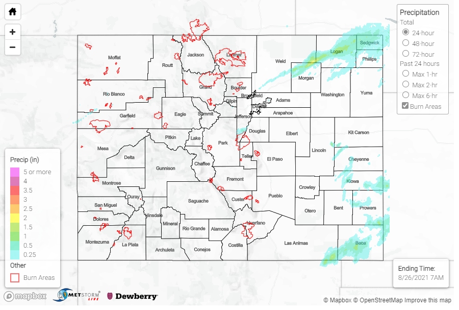
The map below shows radar-estimated, rainfall gage-adjusted Quantitative Precipitation Estimates (QPE) across Colorado. The map is updated daily during the operational season (May 1 – Sep 30) by 11AM. The following six layers are currently available: 24-hour, 48-hour and 72-hour total precipitation, as well as maximum 1-hour, 2-hour and 6-hour precipitation over the past 24 hour period (to estimate where flash flooding may have occurred). The accumulation ending time is 7AM of the date shown in the bottom right corner. Also shown optionally are vulnerable fire burn areas (post 2012), which are updated throughout the season to include new, vulnerable burn areas. The home button in the top left corner resets the map to the original zoom.

Note: The 24-hour, 48-hour and 72-hour total precipitation do not contain bias corrections today due to errors in the CoCoRaHS data. This means there may be underestimations in QPE over the southwest and southeast corners of the state.

SPM 08-25-2021: Near Record Breaking Heat Across Colorado

Issue Date: Wednesday, August 25th, 2021
Issue Time: 9:20 AM MDT

Summary:

Southwest flow across the state has maintained the hot and dry conditions we’ve been experiencing over the last few days. There was no rainfall observed across all of Colorado yesterday, aside from lone “Trace” observations in Burlington in the Northeast Plains and Palisade in the Grand Valley.

Instead, late summer heat was the main story with temperatures in the 90s along the Front Range Mountains, Urban Corridor and Grand Valley, and well into the 100s for the Northeast and Southeast Plains. The Northern, Central, and San Juan mountains saw temperatures reach into the 80s as well. Colorado Springs tied their record high of 94 yesterday afternoon.

An overnight frontal passage cooled things off for some along the Urban Corridor and Northeast Plains, but also ushered in smoke from wildfires burning throughout the west. No flooding was reported on Tuesday. For rainfall estimates in your area, including antecedent conditions, check out the State Precipitation Map below.

Click Here For Map Overview

The map below shows radar-estimated, rainfall gage-adjusted Quantitative Precipitation Estimates (QPE) across Colorado. The map is updated daily during the operational season (May 1 – Sep 30) by 11AM. The following six layers are currently available: 24-hour, 48-hour and 72-hour total precipitation, as well as maximum 1-hour, 2-hour and 6-hour precipitation over the past 24 hour period (to estimate where flash flooding may have occurred). The accumulation ending time is 7AM of the date shown in the bottom right corner. Also shown optionally are vulnerable fire burn areas (post 2012), which are updated throughout the season to include new, vulnerable burn areas. The home button in the top left corner resets the map to the original zoom.

SPM 08-24-2021: Still Hot, Still Dry

Issue Date: Tuesday, August 24th, 2021
Issue Time: 9:20 AM MDT

Summary:

Another hot and dry day across Colorado, with very little precipitation to report. Widely isolated showers produced small rainfall totals in the Western Slopes, Grand Valley, Northern, Central, and Front Range Mountains, as well as the Urban Corridor – but rainfall totals remained less than 0.10 inches and showers were few and far between. Instead, non-thunderstorm high wind gusts, up to 52 mph, were reported in the Grand Valley and Central Mountains. On the Northeast Plains, a line storms developed along the I-76 corridor in the late evening. North Sterling near the reservoir received 0.23 inches around 8:00 pm, the highest precipitation across the state yesterday. Most nearby totals remain between Trace – 0.08 inches though.

Flooding was not reported on Monday. For rainfall estimates in your area, including antecedent rainfall, check out the State Precipitation Map below.

Click Here For Map Overview

The map below shows radar-estimated, rainfall gage-adjusted Quantitative Precipitation Estimates (QPE) across Colorado. The map is updated daily during the operational season (May 1 – Sep 30) by 11AM. The following six layers are currently available: 24-hour, 48-hour and 72-hour total precipitation, as well as maximum 1-hour, 2-hour and 6-hour precipitation over the past 24 hour period (to estimate where flash flooding may have occurred). The accumulation ending time is 7AM of the date shown in the bottom right corner. Also shown optionally are vulnerable fire burn areas (post 2012), which are updated throughout the season to include new, vulnerable burn areas. The home button in the top left corner resets the map to the original zoom.