Issue Date: Thursday, August 26th, 2021
Issue Time: 9:50 AM MDT
Summary:
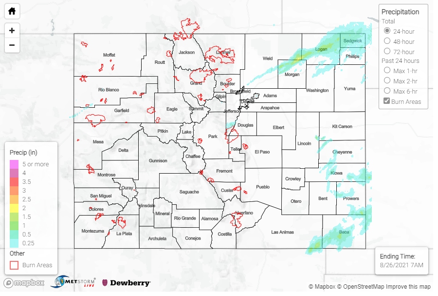
Wednesday began as a clear day for most of the state, with the exception of some lingering fog in the Southeast Plains after the overnight passage of a cold-front on Tuesday. As the day progressed, the afternoon daytime heating allowed for much more exciting weather. Isolated convection began on the Northeast Plains in the early afternoon, with storms moving eastward and out into Kansas and Nebraska before becoming more organized. Lines of showers and thunderstorms also fired in the Southeast Plains in the afternoon to evening, and a couple showers managed to pop up in the Urban Corridor around Southeast Denver.
Overnight, activity picked up again with more storms in the Northeast and Southeast Plains. Widespread, training thunderstorms prompted a severe thunderstorm warning for large hail, up to half-dollar size, in Logan, Morgan, and Weld counties. Up to 1.65 inches of rain was reported by a CoCoRaHS observer in Iliff, and up to 1.21 inches in Sterling. Nearby totals along the I-76 corridor on the Northeast Plains range between 0.22-0.56 inches as well. While no severe warnings were issued, the Palmer Ridge and Southeast plains saw plenty of storm coverage as well. As storms cleared out in the early morning hours, ample moisture left behind resulted in dense fog. Overnight visibility in Wray was reportedly only 1/4 of mile.
In Western Colorado, a low-pressure trough moving eastward into the state late overnight into the early morning produced showers along the Northwest Slope and Grand Valley. Rainfall totals have been light so far, with morning observations catching just the very beginning of likely long-duration showers.
No flooding was reported on Wednesday. For rainfall estimates in your area, check out the State Precipitation Map below.
Click Here For Map Overview
Note: The 24-hour, 48-hour and 72-hour total precipitation do not contain bias corrections today due to errors in the CoCoRaHS data. This means there may be underestimations in QPE over the southwest and southeast corners of the state.
