SPM 09-20-2021: Cold Front Brings Snow to High Elevations

Issue Date: Monday, September 20th, 2021
Issue Time: 10:40 AM MDT

Summary:

A cold-frontal passage and associated trough entered the state from the northwest late Sunday evening, drastically changing the weather pattern for Colorado. Thunderstorms began to form in the Northwest Slope and Northern Mountains ahead of the front in the early evening, and included some high, gusty winds – a 46-mph gust was reported in Hayden. With the eastward progression of the front, showers became more widespread over the Northern, Central, and Front Range Mountains but lacked the necessary instability for heavy rainfall due to the timing of the passage over the evening hours into the night. Temperatures were also lowered enough from the frontal passage for precipitation to fall as snow at high elevations, which limits runoff.

A CoCoRaHS observer in Clark reported 1.2 inches of snow on the ground after the front and 0.81 inches of liquid once the snow/icy mix was melted down. The Steamboat Springs area received between 0.50-0.72 inches of liquid precipitation. An observer in Parshall recorded 0.71 inches yesterday, with the following remark about the nature of the precipitation:

Precipitation was a mix of rain, graupel, and snow accompanied by wind and a little thunder. We don’t see this much precipitation very often from one storm. In the areas where snow accumulated I measured 0.3″. Overall however, it was a trace due to bare areas.

Rainfall totals decreased as the front continued to progress eastward over the Urban Corridor and Northeast Plains. A secondary boundary ahead of the trough also formed on the Northeast Plains overnight, kicking off some light precipitation but nothing notable. Rainfall totals across Fort Collins range from Trace – 0.16 inches.

No flooding was reported on Sunday. For rainfall estimates in your area, check out the State Precipitation Map below.

The Pueblo radar is currently being upgraded and is offline for the next few weeks, so radar-based precipitation estimates for Southeast Colorado are having to rely on further radars in Denver, New Mexico, Texas, and Kansas. This will result in precipitation being underestimated for this region. More information the radar upgrade can be found here.

Click Here For Map Overview

The map below shows radar-estimated, rainfall gage-adjusted Quantitative Precipitation Estimates (QPE) across Colorado. The map is updated daily during the operational season (May 1 – Sep 30) by 11AM. The following six layers are currently available: 24-hour, 48-hour and 72-hour total precipitation, as well as maximum 1-hour, 2-hour and 6-hour precipitation over the past 24 hour period (to estimate where flash flooding may have occurred). The accumulation ending time is 7AM of the date shown in the bottom right corner. Also shown optionally are vulnerable fire burn areas (post 2012), which are updated throughout the season to include new, vulnerable burn areas. The home button in the top left corner resets the map to the original zoom.

SPM 09-19-2021: High Winds and Widespread Showers for Western Colorado

Issue Date: Sunday, September 18th, 2021
Issue Time: 10:00 AM MDT

Summary:

Saturday saw an increase in cloud coverage and cooler temperatures west of the Continental Divide due to a shortwave entering the state ahead of the eastward progression of a larger trough to the west. By evening, there was widespread thunderstorm activity along the Western Slopes and Grand Valley, though the main threat from these initial storms was high winds. Gusty, high winds from thunderstorms exceeding 45 mph were reported all along Western Colorado, from Craig in the north to Cortez in the south – and Rifle had winds up to 63 mph!

As daytime heating waned, storms became more stratiform in nature rather than convective. This allowed for widespread showers in the overnight hours, however with low rainfall rates due to very dry atmosphere that had to become saturated first earlier in the day. Still, there were some notable 24-hour rainfall totals and light snow was even reported on some mountain peaks:

  • 0.46 inches in Rico and Cortez
  • 0.43 inches in Cedaredge
  • 0.40 inches in Mancos
  • 0.37 inches in Ouray, and snow on Chicago Peak from the CoCoRaHS remark
  • 0.29 inches in Palisade and Hotchkiss

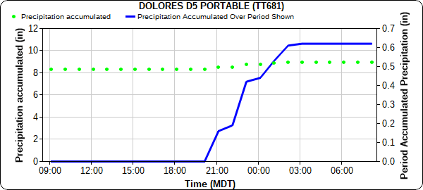
A RAWS station in Dolores picked up 0.63 inches of rain from around 8:00 pm last night, wrapping up around 2:00 am this morning, as seen in the hyetograph below.

A low flood threat risk was issued yesterday for the Grizzly Creek burn scar. Glenwood Springs and the surrounding area received between 0.10-0.47 inches of rain according to CoCoRaHS observers and automated MesoWest gauges. However, rainfall rates of 0.10-0.25 inches/hour remained low enough to prevent excessive runoff.

For Eastern Colorado, downsloping winds brought a return of late summer heat and dry conditions. Unseasonably high temperatures were in the upper 80s and low 90s for the Front Range and Southeast Mountains, Urban Corridor, Palmer and Raton Ridge, and Eastern Plains. Denver tied their record high of 93 degrees yesterday, first set in 1895. No flooding was reported on Saturday. For rainfall estimates in your area, check out the State Precipitation Map below.

The Pueblo radar is currently being upgraded and is offline for the next few weeks, so radar-based precipitation estimates for Southeast Colorado are having to rely on further radars in Denver, New Mexico, Texas, and Kansas. This will result in precipitation being underestimated for this region. More information the radar upgrade can be found here.

Click Here For Map Overview
The map below shows radar-estimated, rainfall gage-adjusted Quantitative Precipitation Estimates (QPE) across Colorado. The map is updated daily during the operational season (May 1 – Sep 30) by 11AM. The following six layers are currently available: 24-hour, 48-hour and 72-hour total precipitation, as well as maximum 1-hour, 2-hour and 6-hour precipitation over the past 24 hour period (to estimate where flash flooding may have occurred). The accumulation ending time is 7AM of the date shown in the bottom right corner. Also shown optionally are vulnerable fire burn areas (post 2012), which are updated throughout the season to include new, vulnerable burn areas. The home button in the top left corner resets the map to the original zoom.

SPM 09-18-2021: Short-Lived Fall-like Day

Issue Date: Saturday, September 18th, 2021
Issue Time: 9:40 AM MDT

Summary:

Friday came and went uneventfully after the early morning cold-frontal passage, which brought actual fall-like temperatures and cloud cover to the state. Along with the front came high winds for much of Eastern Colorado as well, especially the Southeast Plains. The atmosphere remained dry and stable after the front however, effectively limiting any precipitation across Colorado. No flooding was reported on Friday. For rainfall estimates in your area, check out the State Precipitation Map at the end of today’s post.

If it has felt like this summer has been a particularly warm one, that’s because it’s true. Atmospheric scientists from the Colorado Climate Center pulled together the number of days reaching 90 degrees or above this year for several climate stations across the state and compared it with the 1991-2010 average number of 90 degree days. All but two stations had more 90 degree days than average this year, Akron and Dillon (Dillon had done). On the flip side, Alamosa had over double the average number of 90 degree days so far, and Steamboat Springs has seen over triple! The tweet from Assistant State Climatologist, Dr. Becky Bolinger, shows the map and table with the information below.

The Pueblo radar is currently being upgraded and is offline for the next few weeks, so radar-based precipitation estimates for Southeast Colorado are having to rely on further radars in Denver, New Mexico, Texas, and Kansas. This will result in precipitation being underestimated for this region. More information the radar upgrade can be found here.

Click Here For Map Overview

The map below shows radar-estimated, rainfall gage-adjusted Quantitative Precipitation Estimates (QPE) across Colorado. The map is updated daily during the operational season (May 1 – Sep 30) by 11AM. The following six layers are currently available: 24-hour, 48-hour and 72-hour total precipitation, as well as maximum 1-hour, 2-hour and 6-hour precipitation over the past 24 hour period (to estimate where flash flooding may have occurred). The accumulation ending time is 7AM of the date shown in the bottom right corner. Also shown optionally are vulnerable fire burn areas (post 2012), which are updated throughout the season to include new, vulnerable burn areas. The home button in the top left corner resets the map to the original zoom.

SPM 09-17-2021: Thunderstorms for Northeast Plains, High Winds Across Eastern Colorado

Issue Date: Friday, September 17th, 2021
Issue Time: 9:40 AM MDT

Summary:

Thursday morning started uneventfully across the state, thanks to plenty of warm and dry air. These conditions, combined with high winds, warranted red flag warnings for Northern and Central Colorado, especially at high elevations. On the Northwest Slope, non-thunderstorm wind gusts reached up to 47 mph, which can be critical for fire weather conditions.

By late afternoon, thunderstorms developed along a cold-frontal boundary dipping into the Northeast Plains. A severe thunderstorm warning was issued on the Colorado-Nebraska border for high winds and up to ping pong ball sized hail. Julesburg received 0.12 inches of rain in just a few minutes from the fast-moving storms. The cold front continued to advance southward over the evening into the overnight hours, causing very gusty winds but no precipitation. 51 mph wind gusts were reported in Colorado Springs, and 58 mph gusts in Pueblo. Windy conditions remain this morning across Southeast Colorado.

No flooding was reported on Thursday. For rainfall estimates in your area, check out the State Precipitation Map below.

The Pueblo radar is currently being upgraded and is offline for the next few weeks, so radar-based precipitation estimates for Southeast Colorado are having to rely on further radars in Denver, New Mexico, Texas, and Kansas. This will result in precipitation being underestimated for this region. More information the radar upgrade can be found here.

Click Here For Map Overview

The map below shows radar-estimated, rainfall gage-adjusted Quantitative Precipitation Estimates (QPE) across Colorado. The map is updated daily during the operational season (May 1 – Sep 30) by 11AM. The following six layers are currently available: 24-hour, 48-hour and 72-hour total precipitation, as well as maximum 1-hour, 2-hour and 6-hour precipitation over the past 24 hour period (to estimate where flash flooding may have occurred). The accumulation ending time is 7AM of the date shown in the bottom right corner. Also shown optionally are vulnerable fire burn areas (post 2012), which are updated throughout the season to include new, vulnerable burn areas. The home button in the top left corner resets the map to the original zoom.