Issue Date: Sunday, September 18th, 2021
Issue Time: 10:00 AM MDT
Summary:
Saturday saw an increase in cloud coverage and cooler temperatures west of the Continental Divide due to a shortwave entering the state ahead of the eastward progression of a larger trough to the west. By evening, there was widespread thunderstorm activity along the Western Slopes and Grand Valley, though the main threat from these initial storms was high winds. Gusty, high winds from thunderstorms exceeding 45 mph were reported all along Western Colorado, from Craig in the north to Cortez in the south – and Rifle had winds up to 63 mph!
As daytime heating waned, storms became more stratiform in nature rather than convective. This allowed for widespread showers in the overnight hours, however with low rainfall rates due to very dry atmosphere that had to become saturated first earlier in the day. Still, there were some notable 24-hour rainfall totals and light snow was even reported on some mountain peaks:
- 0.46 inches in Rico and Cortez
- 0.43 inches in Cedaredge
- 0.40 inches in Mancos
- 0.37 inches in Ouray, and snow on Chicago Peak from the CoCoRaHS remark
- 0.29 inches in Palisade and Hotchkiss
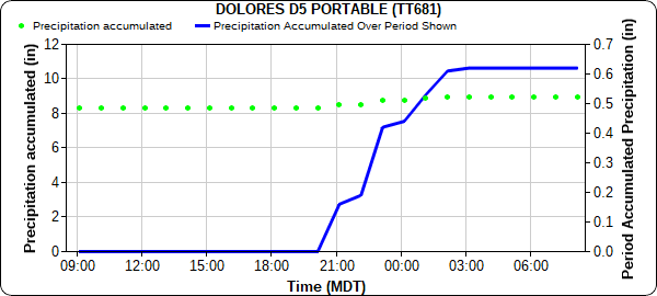
A RAWS station in Dolores picked up 0.63 inches of rain from around 8:00 pm last night, wrapping up around 2:00 am this morning, as seen in the hyetograph below.
A low flood threat risk was issued yesterday for the Grizzly Creek burn scar. Glenwood Springs and the surrounding area received between 0.10-0.47 inches of rain according to CoCoRaHS observers and automated MesoWest gauges. However, rainfall rates of 0.10-0.25 inches/hour remained low enough to prevent excessive runoff.
For Eastern Colorado, downsloping winds brought a return of late summer heat and dry conditions. Unseasonably high temperatures were in the upper 80s and low 90s for the Front Range and Southeast Mountains, Urban Corridor, Palmer and Raton Ridge, and Eastern Plains. Denver tied their record high of 93 degrees yesterday, first set in 1895. No flooding was reported on Saturday. For rainfall estimates in your area, check out the State Precipitation Map below.
The Pueblo radar is currently being upgraded and is offline for the next few weeks, so radar-based precipitation estimates for Southeast Colorado are having to rely on further radars in Denver, New Mexico, Texas, and Kansas. This will result in precipitation being underestimated for this region. More information the radar upgrade can be found here.
Click Here For Map Overview
