STP 05-18-2015: Cloudy, cool and rainy May continues for most

Issue Date: Monday, May 18, 2015
Issue Time: 9:10 AM MDT

Summary:

A very favorable weather pattern continued to provide a perfect recipe for rainfall over most of Colorado. Despite the fact that sunshine has been a hot commodity over the past two to three weeks, most would agree that rainfall is always beneficial given the semi-arid nature of our state’s climate.

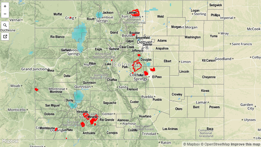
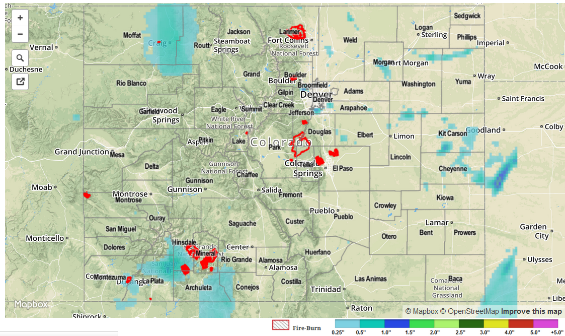
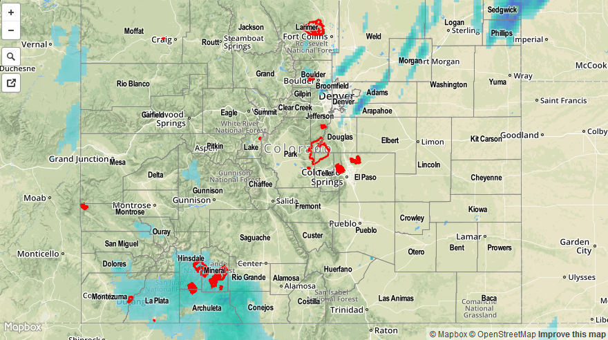
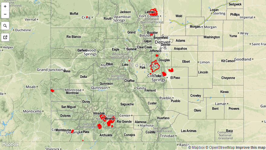
On Sunday, early sunshine covered many parts of the state, especially east of the Divide. However, as the heating of the day began, cumulus clouds were quick to pop by noon. Soon thereafter, the common sound and sight of thunderstorms dotted the landscape. As has been the case during the past several days, while there was adequate moisture available, instability was lacking. The net result was only light precipitation for most. Park, Douglas, Garfield, Teller, Larimer and Weld counties managed to pick up a touch of 0.5 inches of rain. Many other locations experienced 0.25 to 0.5 inches as well.

Perhaps more impressive, however, was the additional snowfall picked up across the higher terrain. After picking up 3 inches of fresh powder yesterday, the notoriously “late-to-close” Arapahoe Basin ski resort will once again live up to its motto. On a more serious note, many high-elevation locations in the drought-plagued southwest and central mountains have seen very beneficial rain and snowfall amounts. Here are a few notable SNOTEL precipitation amounts since May 1st:

Schofield Pass (West Elk Range): 4.7 inches of precipitation
Columbus Basin (San Juan Range): 5.5 inches of precipitation
Wolf Creek Summit (San Juan Range): 6.4 inches of precipitation, 40+ inches of snowfall

No flooding was reported yesterday. Please check the map below for estimated rainfall in your area.

20150518_STPImage
Storm Total Precip Legend

STP 05-17-2015: Two Waves of Precipitation as the Upper-Level Trough Continued Eastward

Issue Date: Sunday, May 17, 2015
Issue Time: 9:00 AM MDT

Summary:

Another day of isolated-to-scattered showers and thunderstorms for low elevations and snow for elevations above 8500-9000 feet befell Colorado yesterday. The first wave moved through during the day, the second wave moved in overnight, and is still producing light rain and snow showers over the high country. The rain and snow of the past few days has been very beneficial, while not producing any flash flood reports, and that is a great thing. It has also been a nice “boost” to the snowpack, just take a look at this report: Since Friday, Ophir (in San Miguel County) has reported 24 inches of heavy snow! As far as rainfall totals are concerned, most were light, as cooler air and average precipitable water values were in place, which is not favorable for heavy rain production. Where better moisture and warmth was in place, namely over the Northeastern Plains, thunderstorms were able to produce rainfall a bit more efficiently, allowing for the 0.65 inch report from Washington County.

For a look at a statewide overview of 24-hour precipitation, be sure and check out the radar-derived STP map below. No flash flooding was reported yesterday.

STP_snapshot_20150517

STP 05-16-2015: Upper Trough on the Move, Another Day of Showers and Thunderstorms

Issue Date: Saturday, May 16th, 2015
Issue Time: 9:00 AM MDT

Summary:

Yesterday featured quite the array of weather, from sunny skies and warmth, to severe thunderstorms, and even snow over the western mountains above 8500 feet. As the upper trough moved east, its attendant dry slot worked in over the eastern half of Colorado, and combined with a developing surface low, acted to mix out moisture over eastern Colorado. This kept rain rates, and thunderstorm coverage, much lower than what could have been, and thus rain totals (and rain rates) were more of the light-to-moderate side of things. For a look at yesterday’s liquid precipitation totals, be sure and check out the radar-estimated precipitation map below.

As far as severe local storm reports are concerned, yesterday provided a fair amount of hail reports of 1+ inches. Those include:

1.50 inch: SE of Julesburg (Sedgwick County)
1.25 inch: 6 miles ESE of Fairfield (Phillips County), NW of Dacono (Weld County), 4 miles WSW of Arapahoe Park (Arapahoe County), and 5 miles NNE of Parker (Douglas County)
1.0 inch: Julesburg (Sedgwick County), 5 miles SSE of Greeley (Weld County), and 1 mile NW of Frederick (Weld County)

No flash flooding occurred yesterday.

05162015_MapImage
Storm Total Precip Legend

STP 05-15-2015: The Beat Goes On

Issue Date: Friday, May 15th, 2015
Issue Time: 9:00 AM MDT

Summary:

A digging trough across the West Coast sent a plume of moisture and broad-scale lift spreading over Colorado yesterday, providing fuel for another bout with showers and thunderstorms. Scattered showers are still ongoing across the western half of the state at this time. Most of the moisture available was in the mid- and upper-levels, so rainfall was not as heavy as it could have been; the vast majority of CoCoRaHS observations were less than 0.2 inches. The strongest storms produced more wind than rain, and a few provided quite the lightning show, as well. For an overview of the past 24-hours of rainfall, be sure check out the Storm Total Precipitation map below.

The only storm report issued to the National Weather Service was for 0.75 inch hail, reported 4 miles NNW of Colorado Springs (El Paso County).

No flash flooding occurred yesterday.

05142015_LFT
Storm Total Precip Legend