STP 08-10-2015: Scattered Thunderstorms Brought Heavy Rain Overnight

Issue Date: Monday, August 10th, 2015
Issue Time: 9:00 AM MDT

Summary:

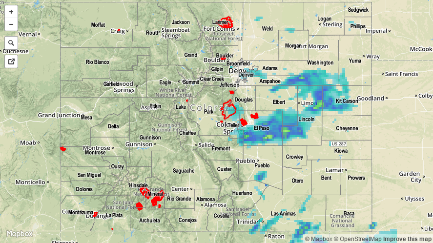
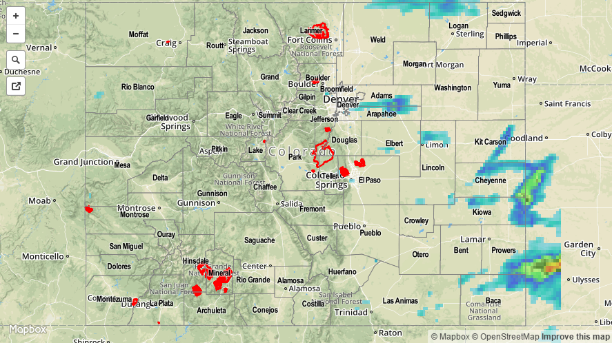
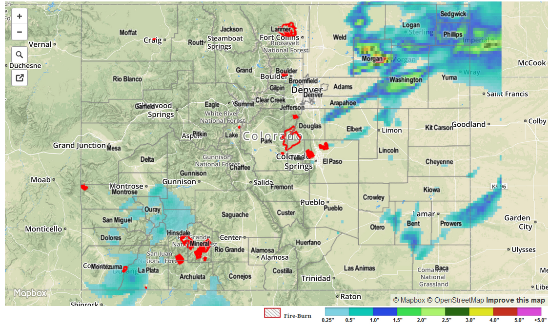
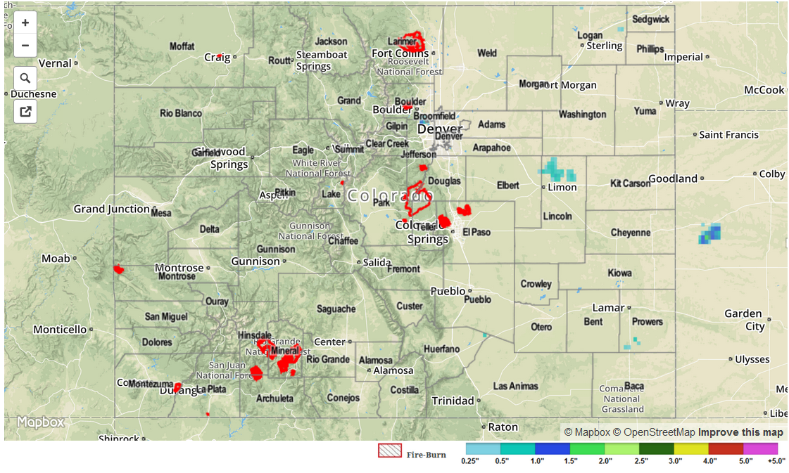
Mostly sunny and hot to start yesterday, becoming partly sunny during the afternoon as scattered thunderstorms developed. Along and west of the Continental Divide, storms did not amount to much, as far as heavy rainfall is concerned. A bit more rain attended storms to the north and east of the Palmer Ridge, but the best rainfall of the day occurred along and south, and to the east, of Palmer Ridge. As the afternoon turned to the evening hours, most activity diminished with the loss of daytime heating, but areas along and south of I-70 from the Front Range and east to the CO/KS border continued to receive scattered thunderstorms. Heavy rain and slow-moving storms prompted a flash flood warning for southern/eastern El Paso County, and flash flooding was reported in Security (El Paso County) where flooded roads were observed.

There were quite a few heavy rain observations reported to the National Weather Service Office in Pueblo. Take a look at a few of the highlights below:

4 miles W of Ellicott (El Paso): 2.73 inches
6 miles W of Fountain (El Paso): 2.39 inches
Shriever AFB (El Paso): 2.30 inches
3 miles W of Fountain (El Paso): 1.14 inches

20150810_STPImage
Storm Total Precip Legend

STP 08-09-2015: Scattered Storms Were Around, But Impacts Were Minimal

Issue Date: 8/9/2015
Issue Time: 8:55AM

Summary:

An intensifying upper-level ridge was detrimental to thunderstorm formation on Saturday. Quite a few storms were observed, ranging from the Grand Valley to the higher terrain of the Central Mountains all the way into the Southeast Plains. But an individual storm was generally only able to maintain strength for 30 minutes or less. Some of the more impressive afternoon storms produced 1 hour rainfall around 1.5 inches in the far southeast corner of the state. Meanwhile, a few additional storms redeveloped into the late evening in a broken line from the Denver Metro area eastward over the Northeast Plains. These produced up to 1.25 inches of rainfall, most of which fell in less than 1 hour.

Although the wind shear (the difference in wind speed at two different layers of the atmosphere) was lower on Saturday, compared to Friday, one storm in Kit Carson County managed to produce hail up to 1.75 inches. In that same region near the Kansas border, many other storms produced hail from 0.5 to 1.0 inch in diameter prompting a handful or so Severe Thunderstorm Warnings from the National Weather Service.

For an estimate of 24-hour rainfall that occurred in your area, please check out our radar based map below. Caution: radar-estimated rainfall can be strongly overpredicted in regions where hail falls.

20150809_STPImage
Storm Total Precip Legend

STP 08-08-2015: Friday Featured A Wide Assortment Of Severe Weather

Issue Date: 8/8/2015
Issue Time: 9:00AM

Summary:

After a very low-key Thursday, the atmosphere quickly rebounded on Friday. A wide variety of weather was observed across Colorado, ranging from beneficial rain showers in the southwest to severe thunderstorms in the northeast. Shower and weak storm activity across the San Juans and Southwest Slope netted anywhere from 0.5 to 0.75 inches of rain. No flooding was reported in that region. Meanwhile, east of the Divide, afternoon thunderstorms got going in earnest after 2PM. Several rounds of storms resulted in very heavy rainfall in Elbert, Arapahoe, Morgan, Sedgwick and Phillips counties. Social media reports described very impressive rainfall near Fort Morgan, where up to 4 inches fell (unofficially). Officially, several CoCoRaHS observations in the regions tallied around 2 inches. Flooded fields and roadways around the Fort Morgan area led to dangerous driving conditions for several hours. In addition, tornado warnings were hoisted as several storms showed strong rotation. While no tornadoes were actually observed, 3.5 inch hail was reported near Wiggins (Morgan County). Other hail reports, exceeding 1 inch, were received from Elbert, Bent and Otero counties. Finally, a thunderstorm wind gust of 65 mph was observed in Bent County, and likely accompanied many other stronger storms yesterday.

Another interesting observation from Friday is the extremely large gradient of precipitable water (PW) values. By late morning, PWs ranged from about 0.5 inches in Boulder to 0.95 in near Colorado Springs to 1.2 inches near Pueblo. This is about the highest disparity that we have ever noticed and certainly helps to explain why thunderstorms had such a difficult time maintaining strength in the Front Range and Urban Corridor.

For an estimate of 24-hour rainfall that occurred in your area, please check out our radar based map below. Caution: radar-estimated rainfall can be strongly over-predicted in regions where hail falls.

STP_snapshot_20150808

STP 08-07-2015: Mostly Sunny, Hot, and Dry

Issue Date: Friday, July 7th, 2015
Issue Time: 9:00 AM MDT

Summary:

There isn’t much to discuss in this STP discussion; yesterday was dry across the state thanks to an upper-level ridge dominating our weather. Precipitable water values continued their fall as drier air was pulled in from the west and monsoonal moisture was limited to states to our south and southwest. Today will be a different story, so be sure to check in on the Flood Threat Bulletin.

No flash flooding was observed.

STP_snapshot_20150808