STP 06-02-2016: Scattered Thunderstorms Mainly East of the Continental Divide

Issue Date: Thursday, June 2nd, 2016
Issue Time: 9:05AM MDT

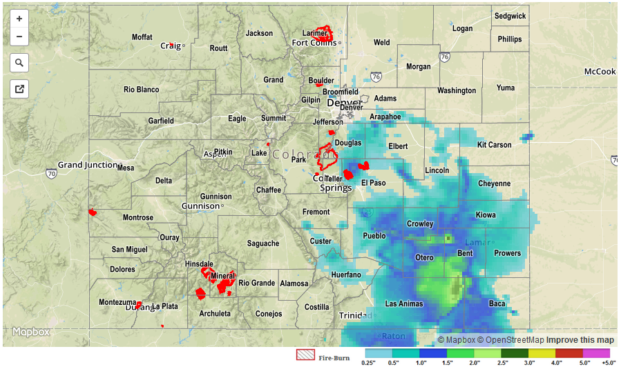
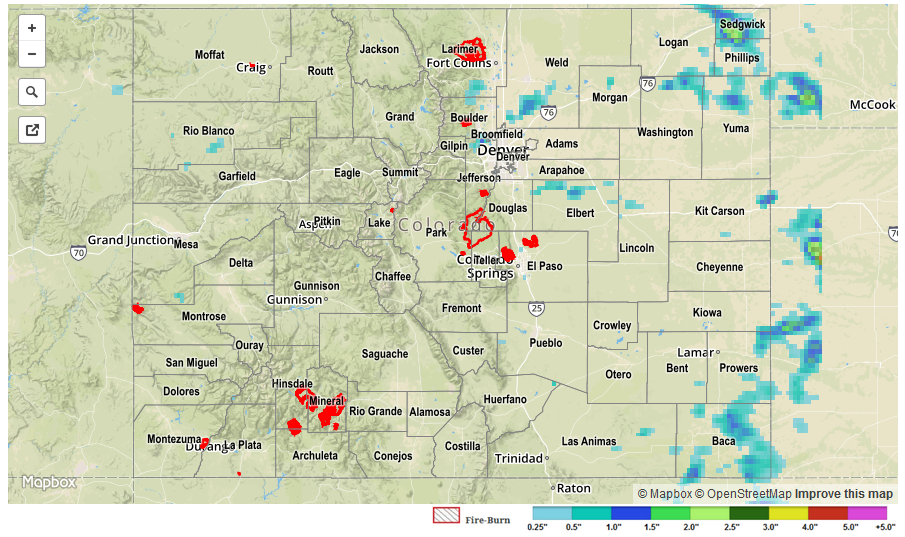
It took a bit longer than normal for thunderstorm activity to get going in earnest on Wednesday, with early afternoon activity limited to the San Juans and San Luis Valley zones. But by early evening, several clusters of stronger storms were found in the Northeast Plains, Front Range, Southeast Mountains and Raton Ridge zones. Most of the storms were generally benign and had more bark than bite. However, a few of the strongest cells produced noteworthy rain amounts exceeding 1.0 inch per hour. The highest 24-hour totals, per this morning’s CoCoRaHS reports, are Akron (Washington County) with 1.98, Illiff (Logan County) with 1.09 and Rye (Pueblo County) with 1.02 inches. Numerous other locations received between 0.25 and 0.5 inches of rainfall. On an interesting side note, even one of the climatologically driest locations in the state, the Great Sand Dunes, managed to pick up about 0.5 inches!

No flooding was reported on Wednesday, but an Areal Flood Advisory was issued for Morgan County around midnight, suggesting at least some field flooding was possible. For specific rainfall estimates in your area, please check our STP map below.
STP_20160602
 

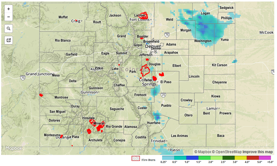
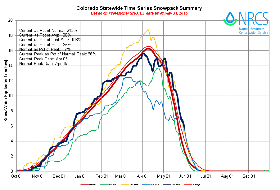
Switching topics, below is the latest statewide snow water equivalent map. Snowmelt is progressing gradually but is expected to ramp up with the coming warm weather. However, with more than half of the snow pack already gone and generally calm weather in the near-term, we expect the snowmelt season to finish in an orderly fashion, void of major flooding concerns.

statewide_SWE

STP 06-01-2016: Widespread Heavy Rain After Sunset

Issue Date: Wednesday, June 1st, 2016
Issue Time: 9:14AM MDT

In the summertime, the usual daily weather cycle across Colorado is for rain to fall in the mid to late afternoon hours, followed by dissipation towards sunset. Of course, there are many exceptions to this generality, as was seen on Wednesday. Scattered storms developed off the higher peaks of the Front Range and Southeast Mountains by early afternoon and progressed east-southeast. Rainfall with these early storms was light to moderate with rainfall rates of about 0.75 inches per hour being a common value.

However, as time passed, a fetch of moisture advecting up the Arkansas River valley provided more fuel for thunderstorms. Thus, activity quickly ramped up in coverage and intensity after about 6pm. By about 10pm, a widespread swath of very heavy rainfall, up to 2 inches per hour, was found between Pueblo and Lamar. By 11pm, residual instability and a small scale mid-level disturbance even ignited some weaker storms along the foothills of the Urban Corridor and into the Front Range. Fortunately, instability was very limited here and max hourly rainfall rates stayed below about 0.6 inches.

When all was said and done this morning, about half the area of the Southeast Plains received over 1 inch of rain, with a few locations receiving over 2 inches. A few of the more impressive amounts are:

  • Las Animas (Bent County): 2.40 inches
  • Fowler (Otero County): 2.29
  • Crowley (Crowley County): 2.22
  • Pueblo (Pueblo County): 1.67
  • Boulder (Boulder County): 1.38
  • Strasburg (Arapahoe County): 1.23

As expected, the runoff entering the Arkansas River is causing an impressive wave front, as you can see in the observed and forecast hydrograph near La Junta. However, even at the it’s crest, the river is expected to remain below Minor flood stage.

lajunta_hydro

No official flood reports were received as of this morning, although it is likely that isolated field and roadway flooding occurred in rural areas of the Southeast Plains. For specific rainfall estimates in your area, please check our STP map below.
STP_20160601

STP 05-31-2016: Scattered Strong Storms, But Fairly Limited Rainfall

Issue Date: Tuesday, May 31st, 2016
Issue Time: 9:20AM MDT

Memorial Day turned out pleasant for most of the state with ample sunshine and warm, but not hot temperatures. Just like Sunday, a round of thunderstorms developed by early afternoon off the higher terrain east of the Divide and spread into the eastern Plains by later in the afternoon. Closer to the mountains, storms dealt with limited instability and very dry air above the surface. The result was limited rainfall amounts, up to about 0.20 inches, and gusty winds after storm passage. However, as storms progressed farther east, deeper moisture meant more instability and fuel for heavy rainfall and other severe weather. Rainfall amounts up to 1 inch per hour were observed in northeast Colorado, mostly notably Sedgwick, Logan and Baca counties. In addition:

• hail up to 1.5 inches was reported in Kiowa County,
• gusty downdraft winds up to 60mph were reported in Kit Carson, Cheyenne, Logan and Yuma counties,
• a 13-minute long tornado was reported in Logan County, near Peetz, around 2:15PM.

In all, 1 tornado and 5 severe thunderstorm warnings were issued across the Northeast and Southeast Plains. Fortunately, all rainfall fell in an orderly fashion and no flooding reports were received yesterday.

For specific rainfall estimates in your area, please check our STP map below.

STP_20160531

STP 05-30-2016: A few storms amidst lots of sunshine

Issue Date: Monday, May 30th, 2016
Issue Time: 9:05AM MDT

Happy Memorial Day!

Several scattered complexes of weak thunderstorms developed across mainly eastern Colorado on Sunday. Once again, despite impressive storm structure (making for very photogenic pictures), the cells had a hard time getting much rainfall to the ground. The problem? Dewpoint depressions, defined as the difference between the surface air and dewpoint temperatures, were on the order of 30-40 degrees F. As such, rainfall that began to fall out of the cloud base quickly evaporated and cooled the air around it. This “swamp cooler” effect led to widespread gusty winds, even up to 60 mph, prompting several severe thunderstorm warnings. Meanwhile, rainfall totals topped out at about 0.4 inches for a few lucky locales, but with most other observations in the 0.1 to 0.25 inch range. A few 0.75 inch hail reports were received near Manitou Springs, where the 7,000 foot elevation made it easier for hail to reach the ground with minimal melting.

Taking a step back, we have discussed previously how it has been a rather cold May statewide. The updated numbers, see the map below, show that nearly all of Colorado has been below average with a few areas east of the Divide up to 5F below normal! This has certainly been a boon to the high-elevation snowpack with many locations continuing to sport over 1 foot of snow water equivalent (SWE). Some of the more impressive numbers from SNOTEL sites: Tower in the Park Range with 42.6 inches(!), Black Mesa in the San Juans with 27.5 inches, and Never Summer in the Medicine Bow range with 19.2 inches of SWE remaining.

maytemps

No flooding reports were received yesterday. For specific rainfall estimates in your area, please check our STP map below.
STP_20160530