STP 08-29-2016: Stronger Thunderstorms Produced Bouts with Heavy Rain

Issue Date: Monday, August 29th, 2016
Issue Time: 9:00 AM MDT

Summary:

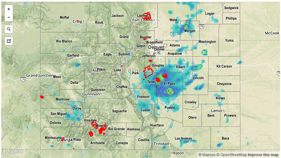
As the upper-level low tracked across the 4-corners region and into northern New Mexico/southern CO, favorable dynamics aloft overspread Colorado, and combined with sufficient moisture/instability to produce isolated-to-scattered showers/thunderstorms through the afternoon and early evening hours. As the evening turned to nighttime, activity diminished across the western slope, but picked up along the Front Range Urban Corridor and adjacent plains. A few stronger thunderstorms produced heavy rain, likely resulting in minor street/field flooding and ponding.

Heavy rain observations (greater than 1 inch) reported to local National Weather Service offices include:

5 miles S of Lindon (Washington): 2.31 inches
8 miles NW of Pinon (Pueblo): 1.49 inches
6 miles SSE of Air Force Academy (El Paso): 1.40 inches
6 miles NW of Peterson AFB (El Paso): 1.10 inches
2 miles NNE of Colorado Springs (El Paso): 1.06 inches
5 miles SSE of Air Force Academy (El Paso): 1.03 inches

For a statewide look at 24-hour precipitation totals, please take a look at the Storm Total Precipitation map below.

STP_20160830
Storm Total Precip Legend

STP 08-28-2016: Isolated-to-Scattered Showers/Storms Dotted the State

Issue Date: Sunday, August 28th, 2016
Issue Time: 9:00 AM MDT

Summary:

The best coverage of showers/storms occurred over the High Country and Western Slope, particularly across the Southwest Slope and San Juan Mountains regions. East of the Divide, activity was mainly isolated, with one or two stronger storms mixed in across the Southeast Plains. Rain rates remained below thresholds, and no flash flooding was reported.

According to CoCoRaHS observers and NRCS Stations, these were the rainfall “winners” from the past 24 hours (as of 7:00 AM MDT):

Cheyenne County: 0.50 inches
Baca County: 0.50 inches
Pueblo County: 0.45 inches
La Plata County: 0.43 inches
Ouray County: 0.43 inches

For a closer look at rainfall totals in your area, please see the STP map below for a look at 24-hour precipitation totals.

20160828_STPImage
Storm Total Precip Legend

STP 08-27-2016: More Activity West of the Divide, A Couple Stronger Thunderstorms East

Issue Date: Friday, May 1st, 2015
Issue Time: 9:00 AM MDT

Summary:

Another upper-level shortwave passed overhead yesterday afternoon/evening, kicking off scattered showers/storms across the Western Slope and High Country. Daytime heating early in the day undoubtedly helped provide the necessary fuel, and a few thunderstorms produced locally moderate-to-heavy rainfall. Storm motions helped mitigate the flood threat, however, and no flash flooding was reported. To the east of the Divide, extensive cloud cover left over from early morning showers/storms limited heating, thus limiting instability, and the environment could only muster a couple isolated showers/storms.

According to CoCoRaHS observers and NRCS Stations, these were the rainfall “winners” from the past 24 hours (as of 7:00 AM MDT):

Pueblo County: 1.65 inches
Yuma County: 0.71 inches
Morgan County: 0.54 inches
Montrose County, Grand County: 0.40 inches
Weld County: 0.33 inches
San Juan County, Broomfield County: 0.30 inches

No flash flooding was reported. For a closer look at rainfall totals in your area, please see the STP map below for a look at 24-hour precipitation totals.

20160827_STPImage
Storm Total Precip Legend

STP 08-26-2016: A Few Stronger Storms Brought Locally Heavy Rainfall and Small Hail

Issue Date: Friday, August 26th, 2016
Issue Time: 9:00 AM MDT

Summary:

The upper-level trough continued to affect Colorado’s weather pattern yesterday, sending a small disturbance across the Colorado during the afternoon/evening hours. This disturbance provided favorable dynamics for the development of scattered showers/thunderstorms, while good moisture and sufficient instability promoted locally heavy rainfall within stronger storms. Drier air over the far eastern plains helped keep rain rates down near the CO/KS border. Storm reports from the local National Weather Service offices include:

Thunderstorm Wind Gust: 51 mph, 5 miles NW of Mack (Mesa)
Hail: 0.25 inch in diameter, 2 miles NW of Ridgeway (Ouray)
Heavy Rain: 1.63 inches, 11 miles E of Delhi (Las Animas)
Heavy Rain: 0.55 inches, 2 miles ENE of Cortez (Montezuma)
Heavy Rain: 0.55 inches, Telluride (San Miguel)

For a statewide look at 24-hour precipitation totals, please take a look at the Storm Total Precipitation map below.

20160826_STPImage
Storm Total Precip Legend