STP 09-06-2016: Showers/Thunderstorms Traversed the Raton Ridge and far Southeast Plains Regions

Issue Date: Tuesday, September 6th, 2016
Issue Time: 9:00 AM MDT

Summary:

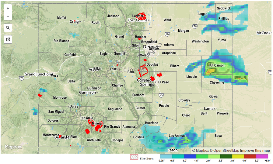
Subtropical moisture rotating through New Mexico eased its way into southeastern portions of Colorado yesterday afternoon and overnight, fueling semi-persistent showers/thunderstorms across the Raton Ridge and far Southeast Plains. Most of the rainfall could be classified as light-to-moderate, with brief periods of heavy rainfall (mainly across Baca County). No flash flooding occurred from the beneficial rainfall. Elsewhere across Colorado, yesterday was marked by mostly sunny skies and warm temperatures, with gusty winds elevating fire danger in a few locations.

For a statewide look at 24-hour precipitation totals, please take a look at the Storm Total Precipitation map below.


Storm Total Precip Legend

STP 09-05-2016: Isolated Thunderstorms Dotted Eastern Colorado, a Couple were Severe

Issue Date: Monday, September 5th, 2016
Issue Time: 9:00 AM MDT

Summary:

Overall, yesterday was a quieter day for most, as Colorado began the transition out of the prolonged active period that had gripped the state for nearly a week. Moisture took a downturn across much of the state, minus the far eastern plains, where better moisture and decent instability resided. This better moisture/instability provided the fuel for isolated afternoon/evening thunderstorms, with a couple becoming severe. Severe storm reports from yesterday include:

3.0 inch hail: 9 miles NNW of Alvin (Yuma)
2.5 inch hail: 7 miles NNW of Alvin (Yuma)
1.75 inch hail: 2 miles N of Hillrose (Morgan), 12 miles SE of Julesburg (Sedgwick), 8 miles SE of Holyoke (Phillips), 3 miles ESE of Idalia (Yuma),
1.0 inch hail: 3 miles SSW of Hillrose (Morgan)
Wind Damage (power pole and 3 foot diameter tree down): Wiley (Prowers)

No flash flooding was reported. For a closer look at rainfall totals in your area, please see the STP map below for a look at 24-hour precipitation totals.

20160905_STPImage
Storm Total Precip Legend

STP 09-04-2016: More Heavy Rainfall Mainly Across Northeast Plains

Issue Date: Sunday, September 4th, 2016
Issue Time: 9:00AM MDT

Summary

Scattered to widespread thunderstorms again dotted mainly northern Colorado on the first day of the Labor Day weekend as a disturbance raced across the state. While rainfall rates were fortunately not nearly as severe as the Friday storms, some still managed to pack a punch. Hourly rain rates up to 1.5 inches were seen across the Northeast Plains, Palmer Ridge and Southeast Plains. The rainfall was surprisingly not the most impressive aspect of the storms; that honor went to hail. Many hail reports exceeding 1.0 inch were received from several storm cells. By far the most impressive reports were of 2 to 3 inch hail being reported with a tornado-warned cell in Akron County shortly before sunset. Damage to roofs and vehicles was reported. Additional severe storms were seen farther south along the Kansas border with hail up to 1.25 inches.

Over the western slope, showers and a few storms raced across the landscape but moved too fast to cause flooding concerns. Instead, 0.25 to 0.6 inches of beneficial rainfall was observed mainly across central and northern areas in better proximity to yesterday’s disturbance.

No official flood reports were received as of this morning. For rainfall estimates specific to your area, check out our Storm Total Precipitation map below.

20160904_STPImage
Storm Total Precip Legend

STP 09-03-2016: Widespread Heavy Rain Out East

Issue Date: Saturday, September 3rd, 2016
Issue Time: 9:00AM MDT

Summary

Some of the heaviest, prolonged rainfall of the entire 2016 warm season was observed on Friday across the far eastern Plains. A marked disturbance traversed the state, but was relatively low key until it encountered the significant instability and moisture content available in eastern Colorado. Thunderstorms quickly erupted in the Northeast Plains, Palmer Ridge, Southeast Plains and Raton Ridge during the mid-afternoon. The southern end activity produced rainfall up to 1.5 inches, but no official flooding reports were received in this region.

A different story was seen farther northeast. Despite relatively fast storm motion, thunderstorm updrafts began “training” or redeveloping over the same region. This is a relatively rare phenomenon that occurs when low-level inflow and mid/upper-level steering winds are offset in an optimal configuration. Two distinct areas of intense rainfall were noted. First, in Yuma County where an initially severe storm (funnel cloud and moderate hail was reported) turned into a heavy rainfall producer as it slowly propagated east. Over 3 inches of rain fell with this storm with reports up to 5.5 inches reported though this was not confirmed. Flash flooding warnings were posted and remain in effect this morning for area roads and streams. The second and more severe area of heavy rain was farther south in Kit Carson and Cheyenne. Here, widespread amounts over 3 inches were estimated by radar also prompting a large flash flood warning area that extended into Kansas. Numerous reports of flooded roadways were received this morning.

Farther west, scattered showers and a few storms were observed over and west of the Continental Divide. Rainfall amounts in the 0.25 to 0.50 inch range were common with isolated higher amounts in favored higher elevation locations (highest SNOTEL reading was 0.8 inches).

For rainfall estimates specific to your area, check out our Storm Total Precipitation map below.

STP_20160903