Issue Date: 5/07/2015
Issue Time: 2:35 PM

What a week it has been so far, with showers and thunderstorms dominating the forecast. This has brought substantial moisture to much of the state, and is an active start to the 2015 flooding season. With that said, it is time to turn our eyes to the future once again…
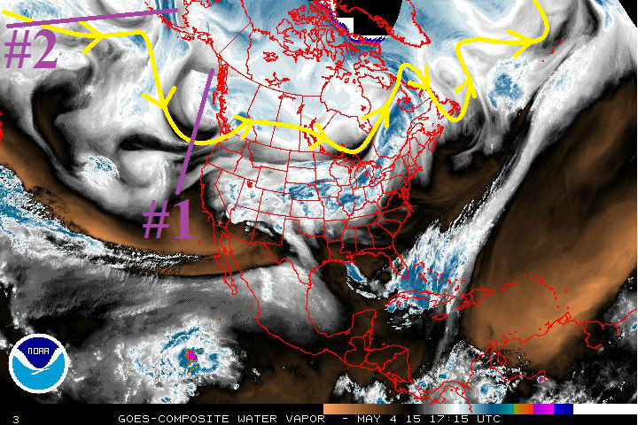
Over the next 15 days, there are 3 events for which this FTO will be focused upon.
- Event #1: Friday (5-8-2015) through Sunday Evening (5-10-2015)
- o The upper-level low, marked by the purple line (and #1) in the water vapor image below has been meandering southward over the last couple of days. It will continue to do so through Sunday, when it will have moved east of Colorado. It has brought, and will continue to bring, an extended period of cool, wet weather to Colorado.
- Event #2: Tuesday (5-12-2015) through Friday morning (5-15-2015)
- o After a short lull following Event #1, a weak, mid-/upper-level system will drop southward along the west coast by Tuesday. It is not highlighted in the water vapor image below because it will eject from the base of the trough known as Event #3 as it spins over the Gulf of Alaska.
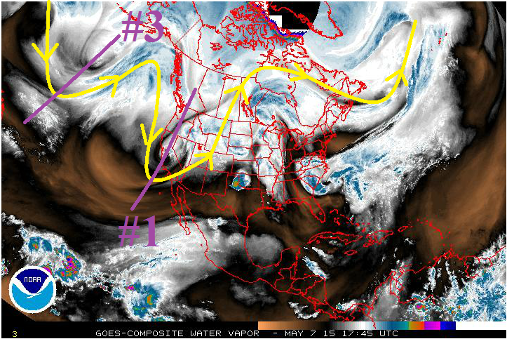
- Event #3: Saturday (5-16-2015) through Tuesday (5-19-2015)
- This system mirrors a lot of what we saw this week; a low that centers itself over the West Coast, with a decent stream of moisture funneling into Colorado. This system will be a bit more transient than Event #1, moving east of the area in a quicker fashion.
In the longer time-frame, we are watching the continuing of El Nino. If El Nino continues into the summer, the odds for a wetter season will increase. This will be important to keep our eye on as the early flooding season progresses. Look for more updates in the coming FTO’s.
Event #1: Tuesday (5-5-2015) through Sunday Evening (5-10-2015)
Slow-Moving System to Bring an Elevated Flood Threat
The upper-level low is still taking its sweet time to move eastward, and has enjoyed an extended stay over the West Coast. It will continue to hang out over the West coast for another day or two, before beginning to shift eastward. Before the movement to the east takes place, Colorado will remain within a preferred zone for large-scale lift and passing mid-level disturbances, continuing the string of showers and thunderstorms. As it shifts eastward, look out for snow and cold temperatures on the backside of the system on Sunday. The dreaded “s” word will make an appearance on Mother’s Day across the high country and urban corridor for a second year in a row.
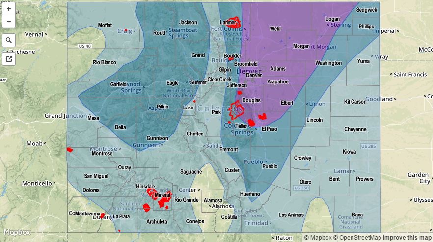
Many places across the state will see an additional 1 inch of liquid precipitation (or more) by the time the event is over, with the mountains and urban corridor picking up a bit of snow as the system exits to the east. Check out the map below for an overview of the expected *liquid* precipitation totals statewide.

Event #2: Tuesday (5-12-2015) through Thursday (5-14-2015)
No Flood Threat
The upper-level low for Event #3 is the “parent” of the weak, upper-level low known as Event #2. Event #2 will provide another shot at unsettled, wet weather for Colorado, though this will be the most transient event of the three. Moisture will not be as deep as with Event #1, and at this time will hold us back from issuing any type of flood threat for this event. Due to the nature of this type of event, be sure to pay attention to the daily FTB forecasts for the most up-to-date information.
Event #3: Saturday (5-16-2015) through Tuesday (5-19-2015)
No Flood Threat Apparent
Event #3 holds a lot of similarities to Event #1, and will bring an extended period of unsettled weather to Colorado. This far in advance, however, there is little certainty with respect to the amount of moisture that will be available to this system. If it evolves anything like Event #1, a flood threat will show up within the next FTO or two.