Issue Date: Sunday, July 21, 2019
Issue Time: 10:45AM MDT
Summary:
Strong upslope flow and a passing shortwave created heavy rain and flash flooding over the Urban Corridor and Eastern Plains. Thunderstorms began to form over the foothills and Continental Divide by midday and moved over the adjacent plains by 2PM. Storm continually formed over the high country throughout the afternoon and into the early evening. Flash flooding occurred over the major metro areas of Denver, Colorado Springs and Pueblo. Notable reports of flash flooding include:
2 miles southeast of Denver (Denver County): southbound I-25 south of 6th Avenue under multiple feet of water
West Colfax and 121st (Denver County): water rescue as flood waters poured into a stalled vehicle
3 miles north of Lakewood (Jefferson County): a few feet of water over the road at 12th and Miller
4 miles north of Manitou Springs (El Paso County): 8 inches of muddy water off of the Waldo Canyon burn area running over roads
4 miles northwest of Blende (Pueblo County): car completely submerged in water
Pueblo (Pueblo County): Flooding up to 8 inches over many roadways
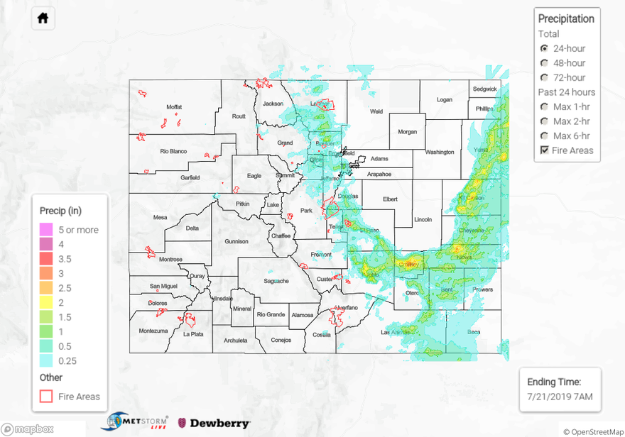
Rain was very heavy over the eastern plains as well. Radar derived up to 3.5 inches in central Crowley County and up to 3 inches in Kiowa and Kit Carson Counties. High, non-tornadic wind gusts were also reported over the eastern plains, with reports to the NWS of 66 mph and 62 mph in Otero County near Cheraw and Prowers County near Lamar respectively. High winds in El Paso County caused downed live trees to fall over roadways southeast of Peterson. Rainfall was also measured west of the Continental Divide, with Eagle County CoCoRaHS stations reporting up to 0.39 inches. Most CoCoRaHS stations over the west reported less than 0.1 inches, but light rain was widespread over most of the area.
For a look at precipitation over your area, please see the State Precipitation Map below.
Click Here For Map Overview