Issue Date: Sunday, July 21, 2019
Issue Time: 10:15AM MDT
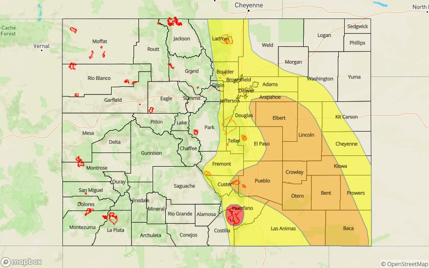
— A HIGH flood threat has been issued for the Spring Creek burn area
— A MODERATE flood threat has been issued for portions of the Palmer Ridge, Southeast Plains, Raton Ridge and Junkins burn area
— A LOW flood threat has been issued for portions of the Front Range, Urban Corridor, Northeast Plains and Hayden Pass burn area
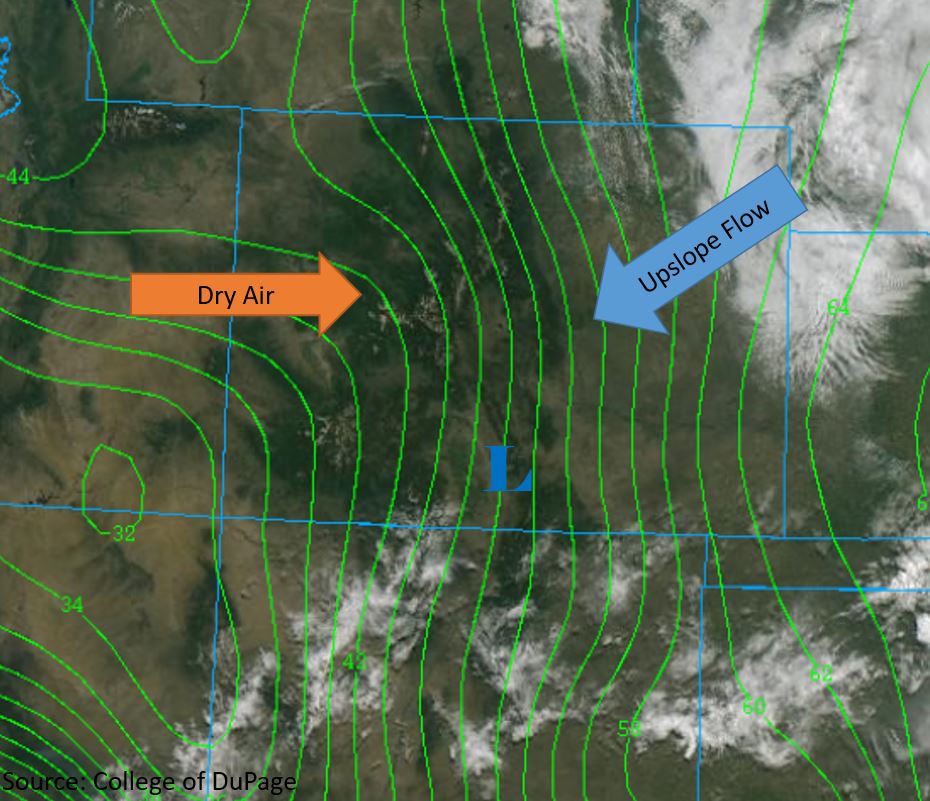
Another day of heavy rain is forecast today as strong upslope flow returns to the east of the Continental Divide. The high pressure ridge that was centered over the Baja Peninsula yesterday shifted eastward and is now positioned over the AZ/NM border. This will bring in drier air to the west of the Divide, thus limiting the chance for thunderstorms over the west today. PW has increased drastically over the eastern plains due to heavy rain yesterday. PW was measured at 0.83 inches over Denver this morning and increases to 1.2 inches over the eastern border. West of the Divide, PW values decrease to 0.4 inches over the Grand Valley and San Juan Mountains. Dewpoints this morning (green contours below) measure in the 50°Fs along the foothills and increase into the 60°Fs over the eastern border, providing ample moisture for afternoon and evening thunderstorms. Surface moisture is expected to remain high over the eastern plains throughout the day.
At the surface, a thermal low (“L” below) is expected to form early this afternoon over the San Luis Valley, creating strong upslope flow along the Front Range, Palmer Ridge and Southeast Mountains. Strong thunderstorms are forecast to form over these areas early this afternoon. Northwesterly steering flows at 20-25 mph will keep storms moving at a moderate pace, however continual upslope flow will cause storms regenerate and train over the same areas. Thunderstorms will favor the Southeast Plains and Palmer Ridge as they move off of the higher terrain. A Flash Flood Watch has been issued over portions of the Southeast Mountains and Wet Mountains, including the Hayden Pass, Junkins, and Spring Creek burn areas.
Today’s Flood Threat Map
For more information on today’s flood threat, see the map below. For Zone-Specific forecasts, scroll below the map.

Zone-Specific Forecasts:
Front Range, Urban Corridor, Palmer Ridge, Southeast Mountains, Raton Ridge, Southeast Plains, and Northeast Plains:
Severe thunderstorms are forecast this afternoon and into the early morning. Storms will form over the Front Range early this afternoon and move to the south/southeast over the Urban Corridor mid-afternoon. Multiple rounds of thunderstorms can be expected over the area, ending around 8PM. Max 1-hour rain rates up to 1.75 inches and max 3-hour rain rates up to 2.25 inches may be possible over the region, with heavier rates favoring the Urban Corridor. Threats include flooding of small streams, roads and low lying intersections with the threat decreasing after 6PM.
Over the Palmer Ridge, Southeast Mountains, Southeast Plains and Raton Ridge, max 1-hour rain rates up to 2.5 inches (east) and 1.5 inches (west) are possible. Isolated 2 to 3 hour totals up to 3.5 inches are possible by early morning. Storms are expected to begin around 2PM and extend until 2AM, with later storms favoring the Southeast Mountains. High rain rates may cause flash flooding of rivers/arroyos, road flooding, and field ponding. Over steep terrain and burn areas threats include debris slides, mud slides, and landslides.
Primetime: 2PM to 2AM
Southeast Slope, San Juan Mountains, Grand Valley, Northwest Slope, Northern Mountains, Central Mountains, San Luis Valley:
Incoming dry air from the west and ample sunshine is expected to mix out surface moisture throughout the day. Isolated weak thunderstorms are possible over the Northern, Central and San Juan Mountains. Max 1-hour rainfall rates of 0.1 inches are forecast over the high terrain. It’s going to be hot over all the forecast zones today, reaching up to 100°F over the Grand Valley, with high temperatures in the 80°Fs and 90°Fs over the other regions.
Primetime: 1PM to 7PM