Issue Date: Saturday, July 20th, 2019
Issue Time: 10:55AM MDT
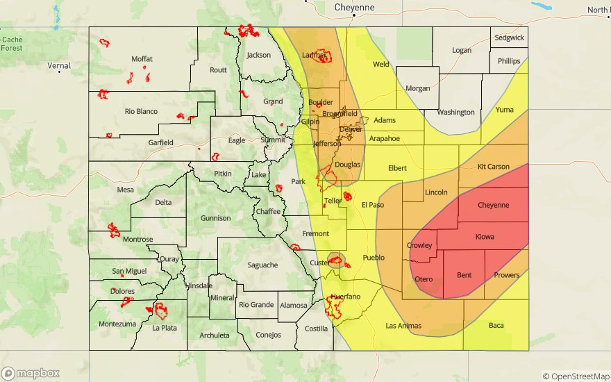
— A HIGH flood threat has been issued for the Southeast Plains
— A MODERATE flood threat has been issued for portions of the Front Range, Urban Corridor, Palmer Ridge, Northeast Plains and Junkins burn area
— A LOW flood threat is issued for the Southeast Mountains, Raton Ridge and Spring Creek burn area.
PM update: Only slight changes to the forecast at this time over the eastern plains. The cold front has moved faster to the south than originally forecast, resulting in a shift south for the High and Moderate flood threat. There is also a slight eastward shift of the Moderate flood threat. Strong surface flow out of the northwest will help storms remain more stationary, therefore rain rates look to increase over the area with max 1-hour rain rates up to 2.75 inches possible. Isolated totals greater than 3.5 inches are still forecast by morning. The heavy rainfall threat for the eastern plains is forecast to end after 1 AM.
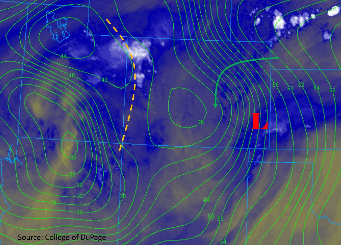
There will be a drastic change in weather today after a couple days of hot temperatures and dry conditions. Heavy rain expected over the eastern portion of the state behind a slow moving cold front. This feature will keep most of the Northeast Plains capped and bring some cooler temperatures back into the forecast behind it. Upper level high pressure zones over the Baja Peninsula and Texas Panhandle will combine with low level moisture behind the front to pull in high moisture from the Pacific. Shown in the water vapor imagery below is a shortwave (marked with an “X”) embedded on the backside of the high pressure system. This feature is forecast to move eastward today/tonight, which will help provide lift and generating a low level vorticity maximum over the eastern plains for overnight rainfall. The surface low that is currently positioned over the CO/KS border will deepen throughout the day as it gains upper level support from the passing shortwave.
Moisture is expected to increase drastically throughout the day over eastern Colorado and into the evening as dewpoints in the mid 60°Fs are advected around the east and north side of the low. PW is forecast to reach between 1.25 and 1.4 inches this afternoon over Denver, nearing the max values seen this time of year. Post frontal upslope flow east of the Continental Divide will provide lift for thunderstorm generation, and slow steering winds (10 mph to the E and SE) will allow for some very high accumulations. Surface based CAPE is forecast to be greatest along the Front Range and Urban Corridor as well as over the Southeast Plains. High levels of instability will create a chance of severe thunderstorms over these areas with the greatest threat over the Southeast Plains and eastern Palmer Ridge. Mid-level moisture is expected to increase throughout the day west of the Continental Divide as well with the shortwave passing over the area this afternoon. Surface moisture is expected to stay fairly low, with dewpoints measured in the 30°Fs and low 40°Fs this morning, but there should be enough moisture for thunderstorms over the higher elevations. Fire danger will also be reduced.
Slow steering winds under storms today (east) will produce some very high rain rates, so flooding is likely with threats being street flooding, flooding of low lying areas and field ponding. Over the higher terrains, including the Junkins and Spring Creek burn areas, mud flows, debris slides and flash flooding will be possible. Thunderstorms look to persist over the Southeast Plains tonight along the boundary with enhanced lift by the shortwave marked below. The MCS is expected to create several flooding hazards with nearly stationary storms over a 2 to 3 hour period. In addition to the threats mentioned above, arroyo flooding and flash flooding of local streams will be possible. The threat ends around 1AM, but light showers will likely persist into tomorrow morning. A High/Moderate flood threat has been issued for today.
Today’s Flood Threat Map
For more information on today’s flood threat, see the map below. For Zone-Specific forecasts, scroll below the map.

Zone-Specific Forecasts:
Front Range, Urban Corridor, Palmer Ridge, Southeast Plains, Northeast Plains, Southeast Mountains, Raton Ridge:
Severe thunderstorms are forecast this afternoon and into tonight over the two regions mentioned above with a High/Moderate flood threat issued. Storms will form over the Front Range just after noon, and move their way east throughout the afternoon and into tonight. The northeast corner of the state looks to remain capped, so eastern plain activity will likely be along the front and south. With nearly stationary storms, the threat today will be 1 to 2 hour totals (west) and 2 to 3 hour totals (eastern plains). Max 1-hour rainfall rates up to 1.8-2.0 inches are forecast over the Front Range and Urban Corridor. Threats include flooding of small streams, roads and low lying intersections with the threat decreasing after 9-10PM. Over the steeper terrains and aforementioned burn areas, debris slides, mud flows and flash flooding are possible.
Over the Palmer Ridge, Southeast Plains and Northeast Plains max 1-hour rainfall rates up to 2.25 inches are possible. Isolated 2 to 3 hour totals greater than 3.5 inches are possible by morning. Reminder, this threat extends overnight with the flood threat decreasing after 1AM. These high rain rates will cause flash flooding of rivers/arroyos, field ponding and road flooding. Some severe storms are also possible earlier in the evening with gusts up 65 mph and hail up to 1.5 inches diameter as additional threats. Lingering showers are possible through tomorrow morning.
Primetime: 2PM to 1AM
Southwest Slope, San Juan Mountains, Grand Valley, Northwest Slope, Northern Mountains, Central Mountains, San Luis Valley:
With an uptick in moisture, though not as great over western Colorado, afternoon and evening thunderstorms return to the forecast. Storms will favor the San Juan Mountains and will likely be more confined to along and near the Continental Divide over the Northern and Central Mountains. Max 1-hour rainfall rates up to 0.8 inches are forecast over the eastern San Juan Mountains and southern/eastern Central Mountains. Max 1-hour rain rates will drop to the 0.25 to 0.5 inch range over the Northern Mountains. Lingering dry air at the surface will limit precipitation over the lower elevations of the forecast area. Storm are expected to dissipate after sundown with the decrease in instability.
Primetime: Noon to 10PM