Issue Date: Wednesday, July 17, 2019
Issue Time: 9:40AM MDT
–Flooding is NOT expected today
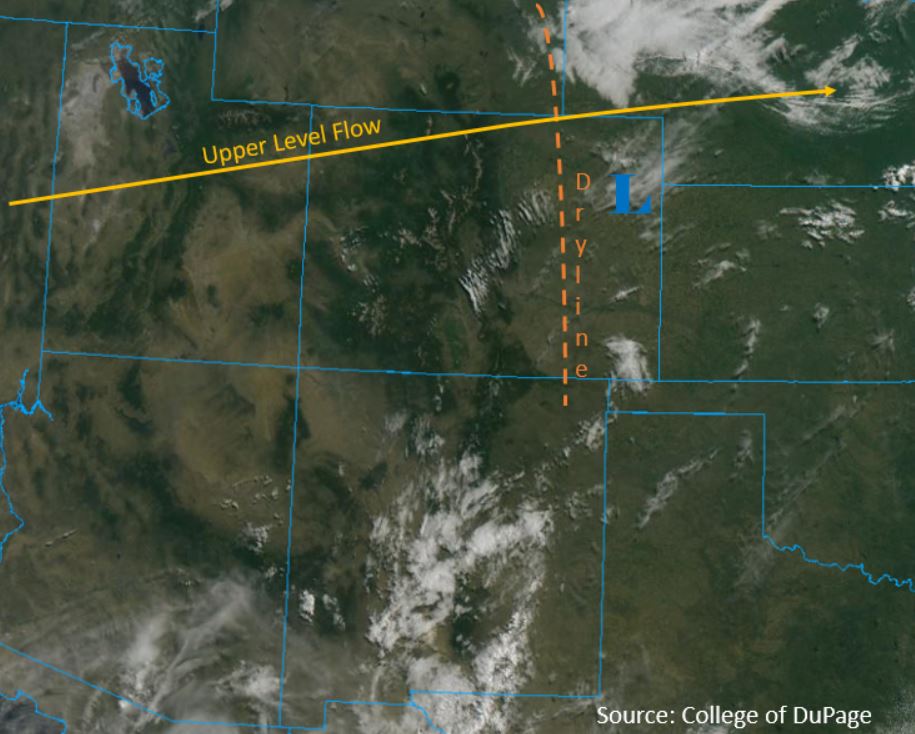
It’s going to be a scorcher out there today, with high temperatures expected in the triple digits over the eastern plains and Grand Valley. The high pressure ridge that was south of Colorado yesterday has moved back to the west, creating zonal flow over the forecast area (yellow line below). This feature will pull in dry air from the west and produce fast winds over the state. The Red Flag Warning continues today and has expanded in spatial area over the western slope for elevations below 7000 ft. The shortwave that passed over Wyoming yesterday has created a broad region of low pressure over the eastern plains. The low will disrupt normal diurnal upslope flow over the mountains by producing downsloping winds off of the Continental Divide, thus limiting chances for thunderstorms over the high country today. A dryline (orange line below) is forecast to form over the eastern plains this morning and into the afternoon, which will provide the primary forcing mechanism for thunderstorms.
Today’s Flood Threat Map
For more information on today’s flood threat, see the map below. For Zone-Specific forecasts, scroll below the map.

Zone-Specific Forecasts:
Front Range, Urban Corridor, Southeast Mountains, Raton Ridge, Palmer Ridge, Northeast Plains, Southeast Plains:
Afternoon thunderstorms are forecast to form over the Palmer Ridge and Southeast Mountains and move quickly to the east. Upper level steering flows are expected to be 30 to 35 mph due rapid zonal flow and a jet streak to our north. Max 1-hr rainfall rates of 0.75 inches and 0.3 inches are forecast over the eastern plains and Southeast Mountains respectively. The primary threat today will be wind gusts up to 45 mph within the storm vicinity. Wind gusts up to 50 mph are forecast over the Front Range due to the jet streak to our north. High temps will reach into the low 100°Fs over the eastern plains.
Primetime: 1PM to 8PM
Northern Mountains, Central Mountains, Northwest Slope, Grand Valley, Southwest Slope, San Juan Mountains, San Luis Valley:
It’s going to be a mostly dry day today over the forecast region with a slight chance for afternoon thunderstorms over the Central Mountains. Max 1-hour rainfall rates of 0.25 inches may occur over the upper elevations. Wind gusts up to 30 mph are forecast over the Northern Mountains and Northwest Slope. Expect high temperatures to reach into the low 100°Fs over the Grand Valley, decreasing into the 80°Fs and upper 70°Fs over the higher elevations of the forecast region.
Primetime: 12PM to 5PM