Issue date: Tuesday, July 16, 2019
Issue time: 10:20AM MDT
–Flooding is NOT expected today
Things are going to continue to dry out today as dry air continues to make its way in from the west-southwest. The dry air, shown in yellow in the water vapor imagery below, and gusty winds over northwest Colorado has prompted the issuance of a Red Flag Warning over the Northwest Slope and Grand Valley. The high pressure ridge that is currently centered over the Colorado/New Mexico border is expected to move slightly to the east throughout the day. Clockwise flow around the high will bring in moderate levels of moisture to the southern mountain ranges and is expected to produce thunderstorms this afternoon and tonight. At the surface there is a high pressure system currently sitting over the high country, providing mostly clear skies over the state and allowing for things to heat up rapidly once again today. A shortwave and surface low is expected to form over southeast Wyoming this afternoon, creating a dry line (orange line below) that will sweep over the eastern plains and produce thunderstorms off of the Cheyenne and Palmer Ridge.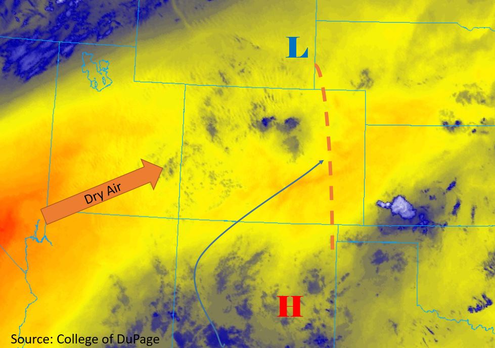
Today’s Flood Threat Map
For more information on today’s flood threat, see the map below. For Zone-Specific forecasts, scroll below the map.

Zone-Specific Forecasts:
Southwest Slope, San Juan Mountains, San Luis Valley, Central Mountains, Southeast Mountains, Grand Valley, Northwest Slope:
There are still moderate levels of surface moisture present this morning from recent rainfall, with dewpoints measuring in the 40°Fs. However, incoming dry air from the west will limit rainfall accumulations over the northern areas of the forecast region today. Moderate mid-level moisture is expected to come in over the southern areas of the forecast area extending up to the Central Mountains. Max 1-hour rainfall rates of 0.6 inches is forecast over the San Juan and Central Mountains. This does not include recent burn areas. Due to gradual drying out of the surface, thunderstorms are expected to be confined to the higher elevations. Max 1-hour rainfall rates decrease down to 0.1 inches for the other areas within the forecast region. Storms are expected to be primarily between noon and 4PM, with a storms over the Southeast Mountains ending by nightfall.
Primetime: 12PM to 9PM
Northern Mountains, Front Range, Urban Corridor, Northeast Plains, Palmer Ridge, Southeast Plains, Raton Ridge:
The dryline associated with the shortwave over Wyoming will aid upslope flow this afternoon to produce thunderstorms over the northern regions of the forecast area. Afternoon development over the southern Urban Corridor and Palmer Ridge is expected. Max 1-hour rainfall rates of 0.7 inches is forecast over the Northeast Plains, Palmer Ridge, and northern area of the Southeast Plains. Thunderstorms are also expected over the Raton Ridge, but the bulk of the precipitation is forecast to remain in New Mexico. Maximum rain rates of 0.6 inches are forecast over the Raton Ridge and southern edge of the Southeast Plains. Maximum 1-hour rainfall rates up to 0.5 inches is forecast over the high country. High temperatures over the eastern plains are forecast to be in the upper 90°Fs and low 100°Fs over the eastern plains. Storms over the high country are forecast to end by 6PM, with storms over the eastern plains forecast to end by 11PM.
Primetime: 1PM to 11PM