Issue Date: Monday, July 15th, 2019
Issue Time: 9:10AM MDT
–A LOW flood threat is issued for the Front Range, Urban Corridor, Northeast Plains, Palmer Ridge and portions of the Southeast Mountains and Southeast Plains. This threat includes the Junkins, Hayden Pass and Spring Creek burn areas.
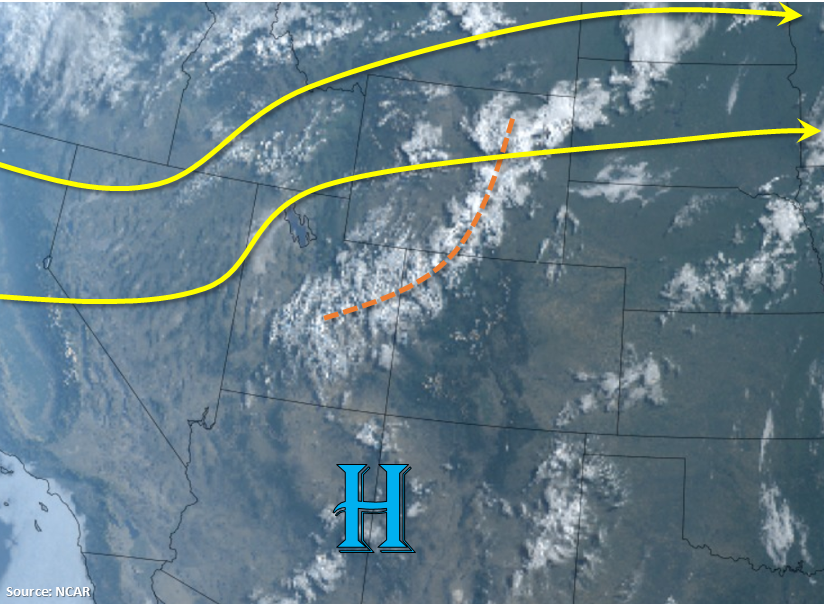
Taking a look at the visible satellite imagery below, the subtropical high has moved a little west and will sit over the Arizona and New Mexico border today. Counter clockwise rotation around the high will produce southwesterly and westerly flow over western Colorado with more northwesterly flow over eastern Colorado in the upper levels. This will pull in a bit of a drier air mass over southwestern Colorado and reduce coverage of heavy rainfall producing storms this afternoon. PW at Denver’s sounding this morning was still elevated at 0.83 inches. Currently, there is a little lift from a shortwave trough causing some early morning cloud cover and isolated areas of rain over the Northwest Slope (marked in orange). As this feature travels to the east throughout the day, it will help spark more numerous showers over the Front Range and Palmer Ridge in tandem with upslope flow this afternoon.
This shortwave will also support storms as the move off the mountains into the adjacent plains. So thunderstorm chances return to the far eastern plains this evening through about midnight. Higher moisture from southeasterly and easterly surface winds over eastern Colorado will allow for some more efficient rainfall rates as well more coverage of thunderstorms just east of the Urban Corridor. Even with steering winds slightly faster than yesterday, totals will likely still cause some minor flooding issues today. A Low flood threat has been issued with the main threats being gusty winds, street and urban flooding and flooding of low lying areas. See the zone-specific forecasts below for more details.
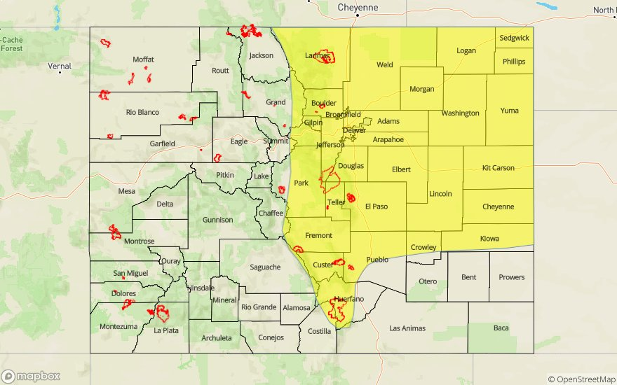
Today’s Flood Threat Map
For more information on today’s flood threat, see the map below. For Zone-Specific forecasts, scroll below the map.

Zone-Specific Forecasts:
Northeast Plains, Palmer Ridge, Front Range, Urban Corridor, Southeast Mountains, Raton Ridge, Southeast Plains:
With a more or less a persistent forecast, storms this afternoon and evening will have the potential to produce heavy rainfall once again. Max 1-hour rain rates up to 0.9 inches (mountains/Urban Corridor) and 1.75 inches (eastern plains) are possible. The burn areas over the Southeast Mountains (Junkins, Hayden and Spring Creek) are also included in the Low threat due to rainfall from the last couple of days and the potential for storms today to produce rain rates known to cause flooding issues. Use caution if a storm tracks over those areas as mud flows, debris slides and flash flooding of streams will be possible. Threats over the adjacent plains include street flooding and flooding of low lying/poorly drained areas. Small hail and brief gusty winds (west) and severe hail and stronger gusts (east) are possible with thunderstorms today and tonight. The threat will diminish to the west by 10PM and by 1AM over the eastern plains.
Primetime: 1:30PM to 1AM
Northwest Slope, Grand Valley, Southwest Slope, Northern Mountains, Central Mountains, San Juan Mountains, San Luis Valley:
Expect storms to pick up in coverage this afternoon with enough residual moisture in place for another round of afternoon and evening thunderstorms. Heavy rainfall producing storms will be a little more isolated when compared to yesterday. The highest totals are anticipated over the eastern Central Mountains and San Juan Mountains by morning. Max 1-hour rain rates up to 0.5 inches will be possible with isolated totals up to 0.80 inches by morning. Over the Northern Mountains, 1-hour rain rates will be closer to 0.3 inches. Flooding is not anticipated at this time.
Primetime: 1PM to 8PM