Issue Date: 6/23/2015
Issue Time: 10:30AM
— Low flood threat for Palmer Ridge and Northeast Plains
— Low flood threat for Arkansas River from Canon City through La Junta
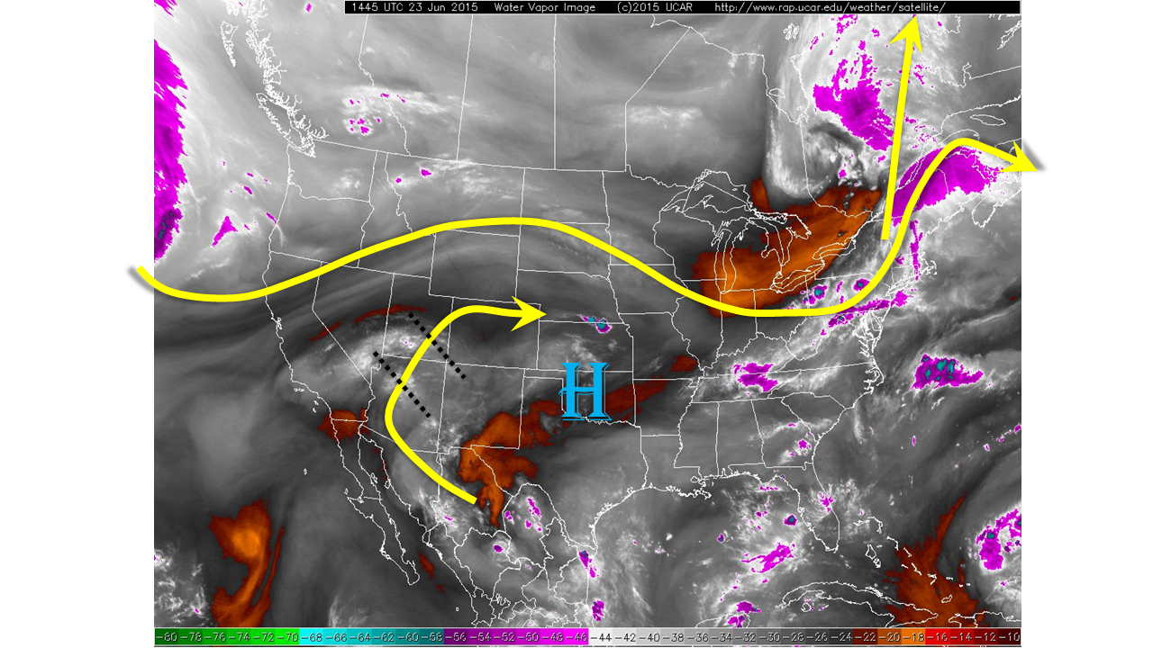
Despite the presence of an upper-level high pressure ridge, storms are back in the picture east of the Continental Divide. The water vapor image, below, shows that the ridge has scooted eastward and has allowed a “return flow” to setup on its western periphery. There are several disturbances embedded in the flow over Arizona and the Four Corners that will help to fire off thunderstorms across Colorado. Acting against storm formation is the very dry air in the mid and upper-levels of the atmosphere. Precipitable water values this morning range from about 0.4 to 0.8 across the state, increasing west to east. The best chances of thunderstorm formation will be where that dry air intrusion is minimized: today we expect that to be over the Palmer Ridge and into the Northeast Plains.
For today, we expect morning sunshine to quickly boost temperatures into the 80s and 90s. Cumulus clouds will form by late morning and lead to isolated thunderstorms over the higher terrain over and east of the Continental Divide. Early storms will produce light rainfall, less than 0.25 inches. As storms mature and merge, heavier rainfall will be possible over the Palmer Ridge and Northeast Plains. A Low flood threat has been issued for these areas. In the Northeast Plains, the wind profile will also allow for large hail, up to 1.5 inches in the strongest cells. Storm activity will quickly subside after sunset closer to the mountains and by midnight towards the Kansas/Nebraska borders.
We have downgraded the Arkansas River to a Low flood threat from Canon City through La Junta. Snow melt is almost complete and very minimal additional rainfall should keep lowering the river levels.
Today’s Flood Threat Map
For more information on today’s flood threat, see the map below (hover over threat areas for more details). For Zone-Specific forecasts, jump below the map.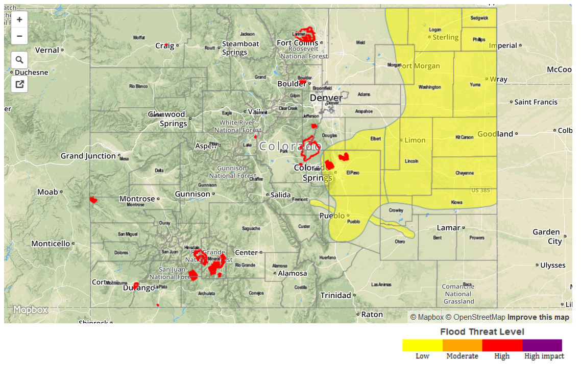
Zone-Specific Forecasts
Grand Valley, Northwest Slope, Southwest Slope, Northern Mountains, Central Mountains:
Sunny to partly cloudy and hot with temperatures in the 90s to near 100F in the lowest elevations. A stray thunderstorm cannot be ruled out in the highest terrain, but little if any rainfall will make it to the ground. No flooding is expected.
San Juans, San Luis Valley, Raton Ridge, Southeast Plains, Southeast Mountains:
Sunny early, then turning partly cloudy. Isolated thunderstorms are possible in the afternoon and early evening. One-hour rainfall up to 0.5 inches is possible, mainly east of the Divide. No flooding is expected.
Front Range, Urban Corridor, Palmer Ridge, Northeast Plains:
Sunny early, with isolated to scattered storms forming by early afternoon. Most storms will be light rainfall producers, but a few isolated cells will be capable of up to 1 inch per hour west of I-25 and 1.6 inches per hour east of I-25. A Low flood threat is in effect for parts of the area. Hail up to 1.5 inches is possible in the strongest cells of the Northeast Plains.
Primetime: 2PM through 9PM, except through 1AM over Northeast Plains