Issue Date: Monday, July, 1st, 2019
Issue Time: 9:10AM MDT
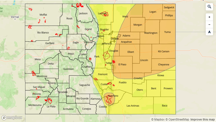
–A MODERATE flood threat is issued for the Palmer Ridge, Northeast Plains, portions of the Urban Corridor and the Spring Creek burn area.
–A LOW flood threat is issued for Front Range, Southeast Mountains, Urban Corridor, Raton Ridge and Southeast Plains. This includes the Junkins and Hayden Pass burn areas.
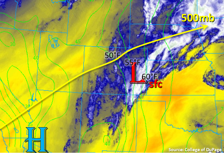
Heavy rainfall returns to the forecast to kick off the first day of July with a Moderate flood threat issued. Southwest flow aloft will begin to turn more westerly throughout the day as the upper level ridge begins to break down. This is in part due to the passage of a shortwave rotating around the high over Mexico. This shortwave will help spark more widespread showers and thunderstorms this afternoon. The current pattern continues to stream in moisture at the mid and upper levels as well, so this will help increase rainfall efficiency with storms this afternoon and evening. In the low level water vapor image below, a very moist air mass is in place over eastern Colorado as shown by the dew points (green lines). Additional moisture will get pulled in over eastern Colorado today with a surface low, which is currently over the eastern plains, siphoning in higher low level moisture (increasing dew points) from the south and east. There is no sounding at Denver this morning, but models and nearby soundings indicate PW values around 1 inches will be present over the Urban Corridor by this afternoon as storms move off the high terrains. As expected, values increase to the east with PW around 1.25 inches over the eastern plains. A weak cold front will produce a wind shift over the Palmer Ridge area and east, which will likely produce convergence for a second set of storms over the eastern plains. Storms to the north of the front will have increased moisture, so higher rain rates are anticipated over this area. Storms over the far eastern plains may become severe with the main threats being heavy rainfall, strong winds and large hail. Back over western Colorado, afternoon storms are forecast for the San Juan Mountains and south Central Mountains, but there is no threat with PW values max out around 0.70 inches.
Slow steering winds under the ridge will allow storms today to produce very heavy rainfall over eastern Colorado. Storm motion is expected to be to the southeast at 10-15 mph to the west, and nearly stationary storms are forecast over the eastern plains. Outflow boundaries from activity will likely kick off additional storms in the moisture rich environment. This evening, it looks like an MCS will form over the eastern plains and last through the overnight hours, which will continue the heavy rainfall threat over this area through tomorrow (early) morning.
Universal flood threats from rainfall today are flooding of small streams, roads and low lying areas, especially over urban areas with larger impervious areas. To the east, there will be the additional threats of arroyo flooding and field ponding. To the west over the higher terrains, mud flows and debris slides may also be possible. This is especially true of any storms that track near recent burn areas over the Southeast Mountains. Elevated flows continue at high elevations streams and rivers (including the Arkansas and Colorado) from the warm temperatures last week and rainfall yesterday. It is anticipated that there will likely be another afternoon peak with higher runoff from rainfall today. This may cause some minor flooding over low lying areas, so use extra caution around these areas this afternoon. There was also a release at Pueblo Dam yesterday, so watch for minor flooding along the lower Arkansas from Avondale to La Junta. Be sure to follow your local NWS office for the latest warnings and advisories.
Today’s Flood Threat Map
For more information on today’s flood threat, see the map below. For Zone-Specific forecasts, scroll below the map.

Zone-Specific Forecasts:
Northeast Plains, Palmer Ridge, Southeast Plains:
Heavy rainfall with the additional threats of large hail (1.75 inch diameter) and strong winds are possible over these areas this afternoon and overnight. The highest rainfall totals are anticipated over the Northeast Plains and Palmer Ridge due to the surface low pulling in ample low level moisture to these areas. Max 1-hr rain rates up to 2.25 inches will be possible. An MCS will likely form in the overnight hours, which will continue the threat through early tomorrow morning. Isolated 24-hour totals just under 3 inches will be possible by morning. These rain rates are anticipated to cause flooding of roads, arroyos, rivers/streams and low lying areas. A Moderate flood threat has been issued.
Primetime: 4PM to 4AM
Front Range, Southeast Mountains, Urban Corridor, Raton Ridge:
Afternoon thunderstorms are expected to kick off with the diurnal flow and shortwave by noon in the moisture rich environment. Storms are forecast to be more widespread over the southern Front Range and Southeast Mountains. Easterly steering flows should push the storms into the adjacent plains by early afternoon. Max 1-hour rain rates up to 1 inch will be possible over the Front Range with max 1-hour values closer to 0.75 inches over the Southeast Mountains. Over the Urban Corridor, max 1-hr rain rates up to 1.2 inches will be possible. A Low flood threat has been issued with a Moderate threat issued for the Spring Creek burn area. A Low threat should suffice for the Junkins and Hayden Pass burn areas. Flash flooding, mud flows and debris slides are possible over the recent burn areas.
Primetime: Noon to 9PM
San Juan Mountains, San Luis Valley, Northwest Slope, Grand Valley, Southwest Slope, Northern Mountains, Central Mountains:
While not quite as much moisture is over western Colorado, there is still some decent low level moisture in place over the southwest corner. This should help produce another round of storms over the San Juan Mountains and south Central Mountains. Isolated weak storms will also be possible over the Grand Valley and Southwest Slope as storms move in from the west. Max 1-hour rain rates up to 0.6 inches may be possible over the Eastern San Juan Mountains with rain rates dropping to 0.25 inches over the lower elevations. Flooding is not forecast.
Primetime: Noon to 9PM