Issue Date: 6/30/2019
Issue Time: 8:20 AM
A LOW FLOOD THREAT HAS BEEN ISSUED FOR PORTIONS OF THE SAN JUAN MOUNTAINS, SOUTHWEST SLOPE, AND CENTRAL MOUNTAINS.
The high-pressure ridge aloft that was a major factor in yesterday’s weather has not budged much at all, and it remains the major feature across the central United States. East of the Continental Divide, this will result in a near carbon copy of yesterday. Hot temperatures will be the main weather story again, with sunshine broken up in the afternoon and evening by scattered thunderstorms. Like yesterday, the main impact of these storms will be periods of light rainfall and gusty winds up to 40-50 mph.
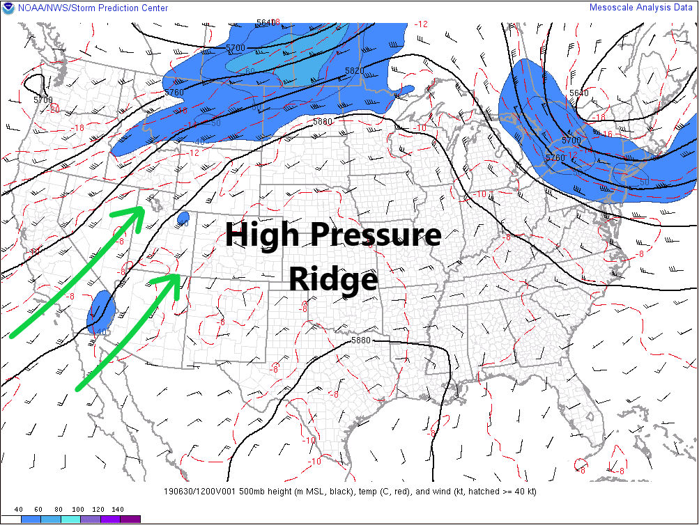
Along and west of the Continental Divide, southwesterly flow aloft (marked by green arrows) will bring an increase in mid-level moisture to the area as remnants of Hurricane Alvin make their way across the Great Basin. This will allow for widespread showers and thunderstorms, beginning between 11 AM – Noon, increasing in coverage through the afternoon and evening hours. Due to the fairly consistent fetch of mid-level moisture from the southwest, as well as the approach of the disturbance formerly known as Alvin, expect scattered showers and weak thunderstorms to continue into tomorrow morning.
For more details on timing and rain rates, please see the zone-specific forecasts below.
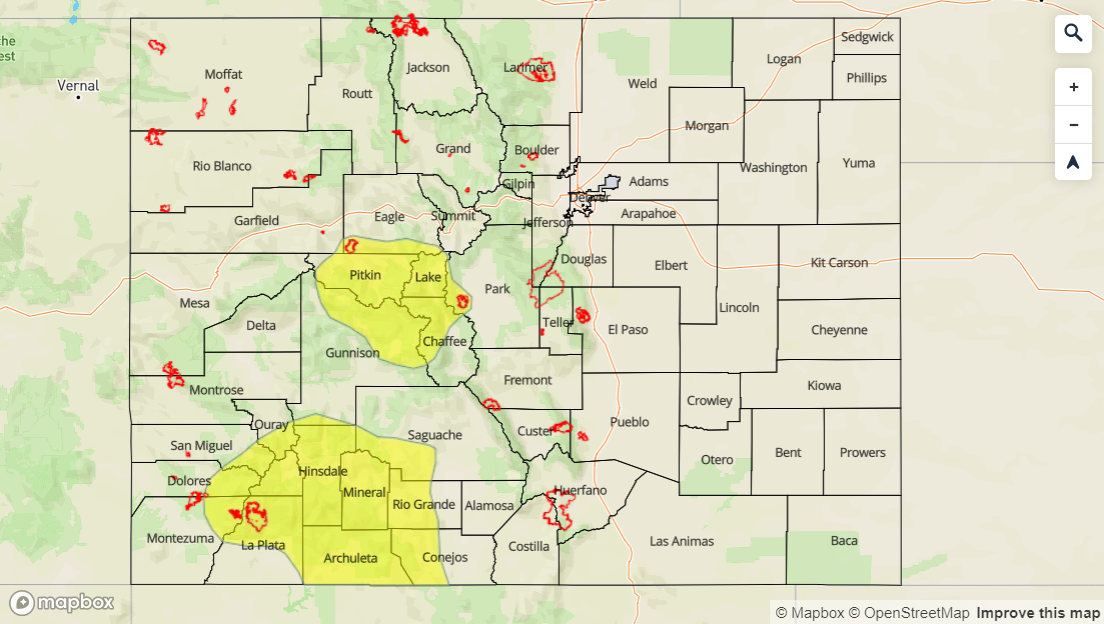
Today’s Flood Threat Map
For more information on today’s flood threat, see the map below. For Zone-Specific forecasts, jump below the map.

Zone-Specific Forecasts
Front Range, Southeast Mountains, Urban Corridor, Northeast Plains, Southeast Plains, Palmer Ridge, and Raton Ridge:
Above average warmth will be the main weather story today as the high pressure aloft continues to be the major player in the forecast. Like yesterday, scattered thunderstorms will develop over the higher terrain between 11 AM and 1 PM, moving eastward over the lower elevations between 1 PM and 3 PM. Coverage will peak during the late afternoon/early evening, and then taper off as the sun sets. Plenty of dry air below cloud bases will once again result in the main impacts being light rainfall and gusty winds up to 40-50 mph. Rain rates will generally be less than 0.2 inches/hour, with maximum rain rates east of the mountains at 0.2-0.5 inches/hour.
Northern Mountains, Northwest Slope, Grand Valley, Central Mountains, San Luis Valley, San Juan Mountains, and Southwest Slope:
Scattered-to-widespread showers and thunderstorms are expected today as an increase is mid-level moisture overspreads the area from the southwest. Low-level moisture remains on the lower end, so the main impacts will be periods of light-to-moderate rainfall, gusty winds up to 50 mph, and a few instances of pea-sized hail. Generally speaking, rain rates will be 0.05-0.2 inches/hour, with maximum rain rates 0.2-0.5 inches/hour. The low flood threat stems from the potential for multiple periods of moderate rainfall moving over the same area.
Timing: 11 AM – Midnight, with scattered showers/thunderstorms lingering into tomorrow morning