Issue Date: Tuesday, June 18th, 2019
Issue Time: 9:35AM MDT
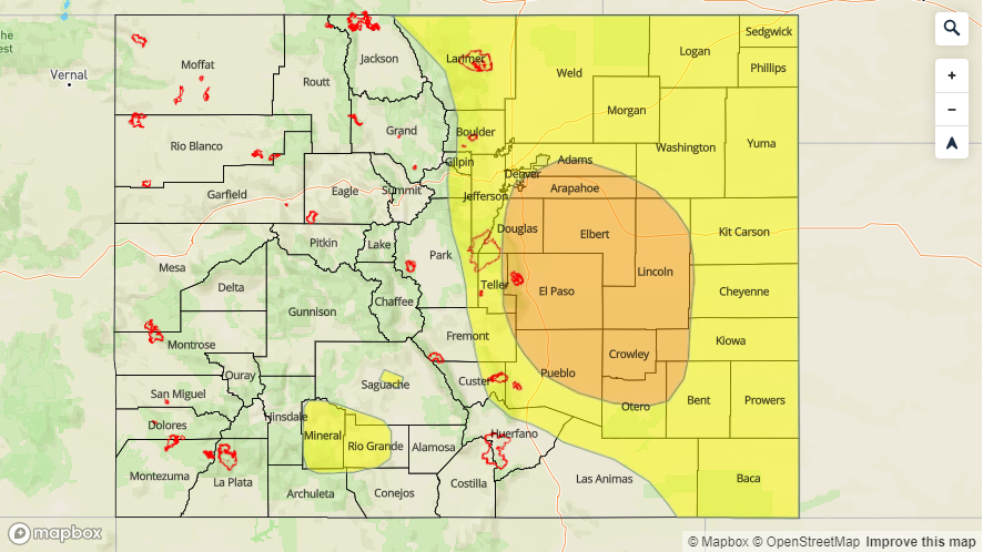
–A MODERATE flood threat is issued for the Palmer Ridge, and portions of the Urban Corridor and Southeast Plains. This includes the Arkansas River downstream of Pueblo Dam to La Junta.
–A LOW flood threat is issued for the Front Range, Urban Corridor, Southeast Plains and Northeast Plains. This includes the Junkins burn area. Additional LOW flood threats have been issued for Saguache Creek and the headwaters of the and along the Rio Grande in Mineral and west Rio Grande Counties.
Taking a look at the visible satellite imagery below, there is a lot of fog, cloud cover and some light rain over the Central Mountains to start the day. Some drier air has worked its way in from the west over the southwest corner. The moisture gradient (green lines, called isopleths) shows dew points have decreased to the low 40°Fs in this area, so clear skies over that region. The surface low, which is currently over the Oklahoma Panhandle area, continues to hold a very moist air mass in place over eastern Colorado. Westerly winds aloft will likely mix some of this moisture out and pull in lower dew points from west near the southern Southeast Mountains. This is similar to yesterday and should limit the heavy rainfall activity over the Raton Ridge area and keep the heavy rainfall threat limited to the foothills and eastern adjacent plains.
A vorticity max from the west (purple dashed line below) will help spark storm activity over the higher terrains by midday and help increase the coverage of storm activity. For western Colorado, highest accumulations will again be over the Northern and Central Mountains with lighter totals over the San Juan Mountains. Storms will likely track in from the west into the lower valleys (except the southwest corner), but flooding is not forecast for these storms. Emergency management reported flooding in the headwaters of and along the Rio Grande in Mineral and west Rio Grande Counties as well as along Saguache Creek. A Low flood threat has been issued for these Flood Warned areas.
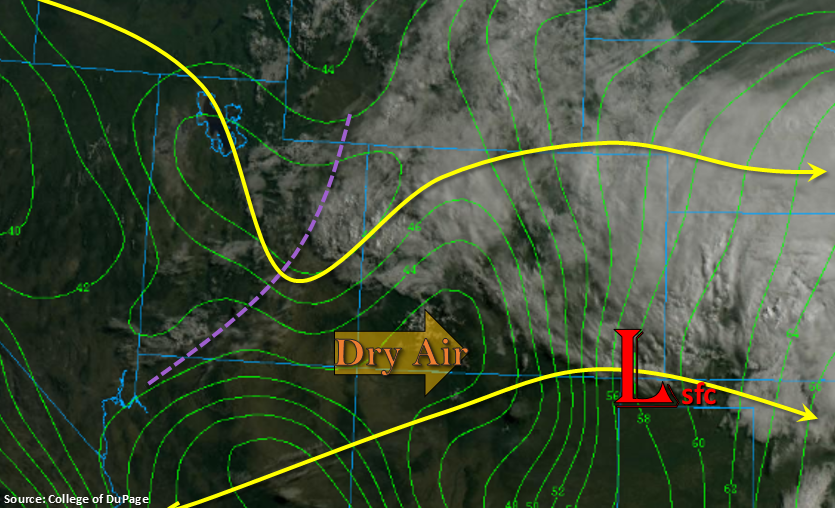
As storms move west off the eastern high terrains, except another MCS to set up over the plains. Heavy rainfall, hail up to 1.75 inches, strong winds (greater than 60 mph) will be possible with the severe storms. Rainfall totals over the eastern border counties yesterday were quite high (see today’s SPM) and likely saturated soils; therefore, except increased runoff over these areas. Even with storm motion slightly faster than yesterday, heavy rainfall and flooding issues will still be likely with dew points over 50°F. PW values at DIA were measured at 0.91 inches (95th percentile), which is a good indication heavy rainfall will occur again this afternoon. Flood threats include street, small stream/river and arroyo flooding along with field ponding. A Moderate threat has been issued for the Palmer Ridge, southern Urban Corridor and portions of the Southeast Plains. Gages continue to run high downstream of Pueblo Dam due to snowmelt and dam releases, so the Arkansas from Pueblo to La Junta is included in the Moderate threat due to the possibility of minor lowland flooding. A Low threat has been issued for all of eastern Colorado minus the Southeast Mountains and Raton Ridge. The Junkins burn area is included in the Low threat, so use caution if a storm tracks over this area as mud flows, debris slides and flash flooding will be possible.
Today’s Flood Threat Map
For more information on today’s flood threat, see the map below. For Zone-Specific forecasts, scroll below the map.

Zone-Specific Forecasts:
Front Range, Southeast Mountains, Raton Ridge, Palmer Ridge, Urban Corridor, Northeast Plains, Southeast Plains, Northwest Slope:
Max 1-hr rain rates up to 1.3 inches are possible this afternoon in the Moderate threat area. Further north along the Urban Corridor, max 1-hr rain rates up to 1.1 inches are possible. Over the eastern plains, totals up to 1.5 inches are possible. While this normally wouldn’t be a threat, saturated soils from yesterday’s ran will increase runoff and the flood risk. Flooding risks today include urban flooding, street flooding, arroyo flooding and field ponding. Storms that track over the Junkins burn area should also be monitored closely as rain rates up to 0.9 inches are possible, which have been known to cause flash flooding and debris slides. A second set of storms is possible over the eastern mountains and Front Range later tonight, but flooding is not anticipated with these storms. Lastly, included in the Moderate flood threat is the area immediately downstream of Pueblo Dam (to La Junta) due to the AHPS gage remaining high throughout the day.
Primetime: 11AM to 3AM
Northern Mountains, Central Mountains, San Juan Mountains, Grand Valley, Southwest Slope, San Luis Valley:
Similar set up to yesterday with storms firing over the high terrains this afternoon. Once again, storms will also track into the lower valleys from the west due to increased mid-level energy in the area. Max 1-hr rain rates up to 0.7 inches (mountains) and 0.5 inches (valleys/west) are possible. Storms may linger over the Northern and Central Mountains tonight, with isolated morning totals up to 1.2 inches. Totals up to 0.15 inches is also possible over the northern portion of the San Luis Valley. The Flood Warning for central Saguache County continues as well as for the headwaters of the Rio Grande. Due to recent reports of minor flooding by emergency management, they have been given a Low flood threat. Please follow your local NWS office for the latest.
Primetime: 11AM to 3AM