Issue Date: Monday, June 17th, 2019
Issue Time: 10:25AM MDT
–A MODERATE flood threat is issued for the Northeast Plains and portions of the Urban Corridor, Palmer Ridge and Southeast Plains. An additional MODERATE flood threat has been issued for the Junkins burn area.
–A LOW flood threat is issued for the Front Range, Urban Corridor, Palmer Ridge, Southeast Mountains and Southeast Plains. An additional LOW flood threat has been issued for the Hayden Pass and Spring Creek burn areas.
—Riverine: A MODERATE flood threat is issued for the Arkansas River downstream of Pueblo Dam to Nepesta. A LOW flood threat continues through this afternoon for Saguache Creek just west of Saguache.
Busy water vapor imagery below to start the work week. Today, a trough will sit to our west once again with a surface low over eastern Colorado. The multiple shortwaves associated with the trough (marked in green) and surface low pulling in low level moisture over eastern Colorado has caused a cloudy, wet and foggy start to the morning. High moisture will remain intact over eastern Colorado thanks to the surface low pulling in high dew points from the south and east throughout the day. Expecting areas east of the white line below to have dew points in the low 50°Fs (west) and upper 50°Fs to 60°F (east) by this afternoon. Large PW values over the Northeast Plains and eastern Las Animas/Baca today will return the heavy rainfall threat for storms that track into this area. As storms form over the mountains early this afternoon, faster storm motion should limit the rainfall threat, thus there is only a Low flood threat to the west. Westerly winds over the south half of eastern Colorado will push the best moisture into the eastern portion of the Southeast Plains. However, enough moisture remains in place to cause issues for storms that track over recent burn areas. Thus, a Low flood threat has been issued for the Spring Creek and Hayden Pass burn areas. A Moderate threat has been issued for the Junkins burn areas as storms are expected increase their rain rates over this area.
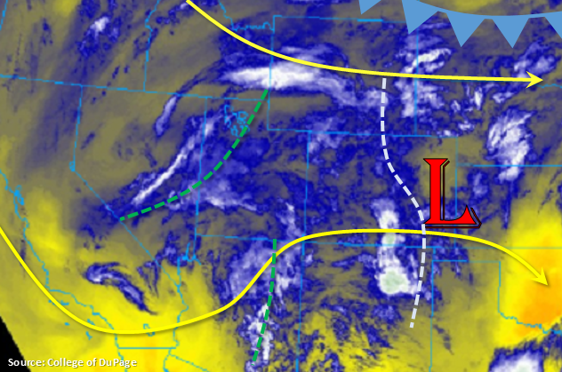
As storms move east, slow steering winds, higher moisture and increased instability will create a favorable severe thunderstorm environment and storms will be capable of producing heavy rainfall. Initially, expect severe thunderstorms to produce large hail (up to 2 inches), strong winds and a tornado or two (northeast corner). By 6PM an MCS looks to form and hangs over the eastern plains through midnight along a convergence boundary. Therefore, high 2-3 hour rainfall totals will likely cause road and small river flooding over the Moderate threat area.
To the west, PW will also continue to increase with southwesterly flow aloft. Mixed with upper level disturbances passing through the area, rainfall should be widespread over this region as well. By early afternoon, forecasting numerous storms to form over the mountains with incoming storms from the west to bring precipitation to the lower valleys. Highest moisture remains over the north, but faster steering winds should prevent flooding. A few storms may linger through midnight over the northwest corner and Central Mountains, so isolated totals up to 1 inch are possible by tomorrow morning.
Riverine flooding continues for another day, although the flood threat is temporarily retreating. A Flood Warning continues for central Saguache County through 2PM this afternoon, so a Low flood threat has been issued for this area. With other Flood Warnings expiring over southeast corner of the state this morning and river levels dropping, increased flooding activity is not expected to be an issue. However, please continue to use caution as flows will remain elevated. A Moderate flood threat has been issued downstream of Pueblo reservoir to Nepesta where increased flows from releases and snow melt have kept the Avondale gage at Minor flooding.
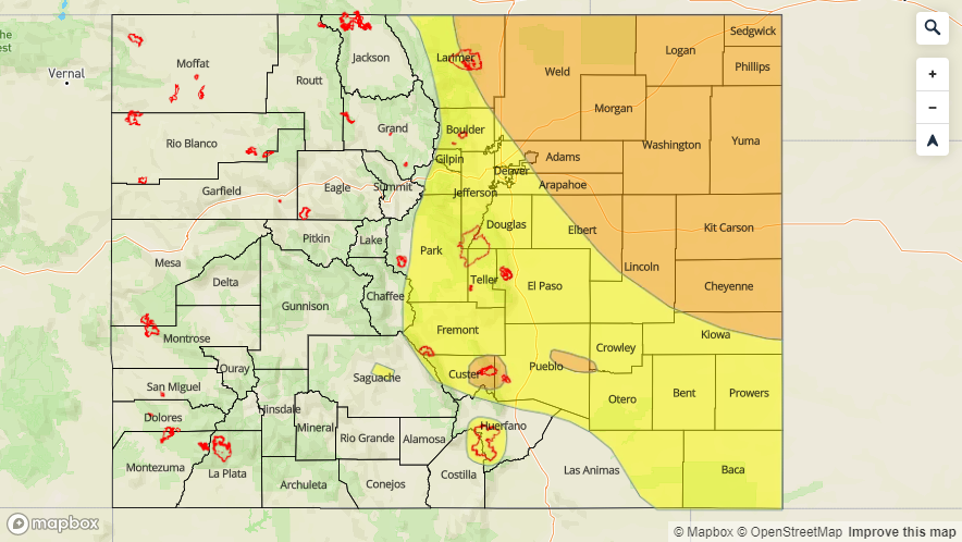
Today’s Flood Threat Map
For more information on today’s flood threat, see the map below. For Zone-Specific forecasts, scroll below the map.

Zone-Specific Forecasts:
Front Range, Southeast Mountains, Raton Ridge, Palmer Ridge, Urban Corridor, Northeast Plains, Southeast Plains, Northwest Slope:
Increased moisture and instability this afternoon will create a heavy rainfall threat for the majority of eastern Colorado. Westerly winds over the Southeast Mountains, should push higher moisture into the eastern portion of the Southeast Plains, but the threat remains for the burn areas. A Low threat has been issued for Hayden Pass and the Spring Creek burn areas with max 1-hr rain rates up to 0.5 inches possible. A Moderate threat has been issued for the Junkins burn area due to rain rates up to 1 inch possible.
Over the northern Urban Corridor and Palmer Ridge, max 1-hr rain rates up to 1.2 inches are possible, so a Low flood threat has been issued. Increasing rain rates over the Northeast Plains and eastern portion of the Palmer Ridge are likely due to increased moisture and slow storm motion. Storms may also produce large hail, gusty winds and a possible tornado. Max 1-hr rain rates up to 1.75 inches are possible. Expecting storms to form an MCS overnight, which may produce isolated totals up to 2.5 inches by morning. Threats today include field ponding, street flooding and small river flooding. 24-hr totals up to 1.75 inches over portions of the Northeast Plains yesterday, will likely increase runoff over these regions.
Lastly, a Moderate flood threat is issued for the area immediately downstream of Pueblo Dam (to Nepesta due to the AHPS gage remaining in the Minor flooding stage throughout the day.
Primetime: 12PM to 1AM
Northern Mountains, Central Mountains, San Juan Mountains, Grand Valley, Southwest Slope, San Luis Valley:
Increased cloud cover this morning with some light showers thanks to a passing upper level shortwave. Moisture will continue to be on the increase over the area with southeast flow aloft. Expecting storms to form over the mountains this afternoon with showers also tracking into the lower valleys from the west. Max 1-hr rain rates up to 0.75 inches (north) and 0.5 inches (south) are possible. Storms may linger over the northwest corner and Central Mountains tonight, with isolated 24-hour totals up to 1 inch by morning.
As of 9AM: The Flood Warning for central Saguache County continues through this afternoon. With decreasing flows forecast today, not thinking anything but a Low flood threat is needed at this time. Please follow your local NWS office for the latest.
Primetime: 12PM to 9AM