Issue Date: 6/15/2019
Issue Time: 9:00 AM
A LOW FLOOD THREAT IS FORECAST TODAY FOR THE FOLLOWING AREAS:
Arkansas River at Canon City due to snowmelt
Arkansas River at Avondale due to snowmelt
Rio Grande in the San Luis Valley due to snowmelt
Portions of the Southeast Mountains, Raton Ridge, and Southeast Plains, mainly for the following burn scars: Hayden Pass, Junkins, Buelah Hill, and Spring Creek.
Portions of the Front Range, Urban Corridor, and Palmer Ridge regions.
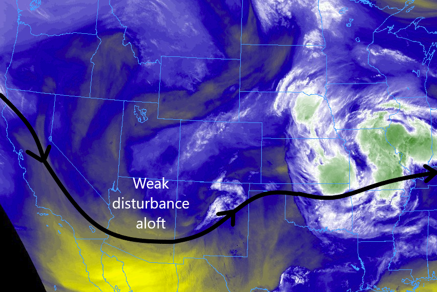
A weak disturbance aloft will shift east-northeast across the southern and Central Rockies today, providing broad upper-level support for scattered showers and thunderstorms across Colorado. All regions are expected to see some shower/storm coverage, but the greatest amount of activity will be over the Southeast Mountains, Raton Mesa, and Southeast Plains, where the best upper-level support and moisture coincide. Most activity will be garden-variety, producing periods of light-to-moderate rainfall and gusty winds. However, a few strong-to-severe storms will develop over the Southeast Mountains, Raton Ridge, and Southeast Plains, capable of periods of heavy rainfall, gusty winds up to 60 mph, and hail up to 1-1.75 inches in diameter. A special forecast discussion for the Spring Creek, Junkins, and Hayden Pass Burn Areas is below.
Spring Creek, Junkins, and Hayden Pass Burn Areas: Scattered showers and thunderstorms are expected to develop over the Southeast Mountains between 11 AM and Noon, continuing until 9-10 PM. Most rainfall will be light-to-moderate, as instability is fairly limited. However, during peak daytime heat (approx. 2 PM – 6 PM), one or two stronger thunderstorms will develop over the region. Should one of these storms move over a burn scar, flash flooding will be likely with maximum rain rates around 0.8-1.2 inches/hour. These scars should be monitored closely.
For more details on timing and rain rates, please see the zone-specific forecast discussions below.
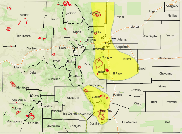
Today’s Flood Threat Map
For more information on today’s flood threat, see the map below. For Zone-Specific forecasts, jump below the map.

Zone-Specific Forecasts
Front Range, Southeast Mountains, Urban Corridor, Northeast Plains, Southeast Plains, Palmer Ridge, and Raton Ridge:
Scattered showers/thunderstorms are expected, beginning during the late morning hours over the Front Range and Southeast Mountains, eventually spreading east over the lower elevations by 2 PM or so. Most of the activity will be garden variety, producing periods of moderate rainfall, gusty winds, and occasional lightning, but a few storms will become strong-to-severe, with attendant periods of heavy rainfall. Maximum rain rates are as follows:
Front Range and Southeast Mountains: 0.8-1.2 inches/hour
Urban Corridor and Palmer Ridge: 1.0-1.5 inches/hour
Northeast Plains and Southeast Plains: 1.25-1.75 inches/hour
Raton Ridge: 0.5-0.9 inches/hour
Most showers/storms will come to an end by 9-10 PM, but a few will linger over the Southeast Plains until Midnight – 1 AM.
Northern Mountains, Northwest Slope, San Luis Valley, Central Mountains, San Juan Mountains, Grand Valley, and Southwest Slope:
Scattered showers and garden-variety thunderstorms are expected today, with the best coverage south of I-70. Periods of light-to-moderate rainfall and gusty winds will be the main impacts, with occasional lightning and small hail attending the stronger, relatively speaking, storms. Showers/storms will begin to develop between 10 AM – Noon over the higher terrain, spreading over lower valleys with time, with most activity coming to an end by 9 PM. A couple isolated showers will continue until midnight or so. Rain rates will generally be less than 0.2 inches/hour, with maximum rates of 0.25-0.5 inches/hour possible.