Issue Date: Friday, June 14th, 2019
Issue Time: 9:35AM MDT
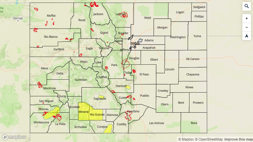
–A LOW flood threat is issued for the Arkansas River at Canon City, Saguache Creek just west of Saguache, Southwestern Rio Grande County/Mineral County (particularly Del Norte) and the Dolores River below Rico
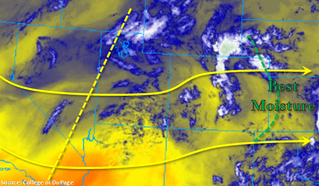
Shallow low level moisture will persist over the state today under northwesterly and westerly flow aloft. The axis of a broad, weak trough can be seen in the yellow dashed line below. Expect this feature to slowly move west throughout the day, which should turn the upper level flow more westerly this afternoon. This will likely set up another dry line over the eastern plains and push the best moisture to our east; thus, limiting the flood threat. Better moisture to the north, seen in the image below associated with another shortwave, will provide more rainfall over the northern half of Colorado.
Diurnal flow along with mid-level dynamics will combine once again this afternoon to kick off storms over the Northern Mountains, north Central Mountains and Front Range (near the Divide). Additional storms will be likely over the Northeast Plains/Palmer Ridge and Northwest Slope as storms move in from the west. High bases and limited moisture over the Southeast Mountains and adjacent Southeast Plains should keep accumulations limited to the far eastern counties. A few storms may continue through midnight over the northern high terrains, but flooding is not expected from rainfall today.
High temperatures continue to rise for today, which will begin to push more gages into Minor and Action stages across the San Juan Mountains, San Luis Valley and upper Arkansas River. A Flood Watch remains in place that covers the Dolores River below Rico, San Luis Valley and eastern San Juan Mountains and will last through this weekend. A Low flood threat has been issued for the Arkansas River at Canon City, Saguache Creek just west of Saguache, Rio Grande River near Del Norte and Southwestern Rio Grande County/Mineral County today. An additional Flood Warning and Low flood threat is issued for the Dolores River below Rico as flow reaches bankfull. This should cover current Flood Warnings issued by NWS (as of 9AM). For the latest, tune into NWS Pueblo and Grand Junction.
Today’s Flood Threat Map
For more information on today’s flood threat, see the map below. For Zone-Specific forecasts, scroll below the map.
Zone-Specific Forecasts:
Northern Mountains, Central Mountains, Front Range, Palmer Ridge, Urban Corridor, Northeast Plains, Southeast Plains, Northwest Slope:
Warmer high temperatures are forecast to increase a couple of degrees again today. Storms will form over the northern mountains early this afternoon favoring development west of the Continental Divide. A secondary set of storms is forecast for the Palmer Ridge/Northeast Plains. Max 1-hr rain rates up to 0.75 inches are possible over both areas. Storminess will also increase over the Northwest Slope again as storms move in from the west. Max 1-hr rain rates up to 0.2 inches are possible. A stronger thunderstorm or two is possible near the Colorado/Kansas border, so severe hail, gusty winds and 0.9 inches of rain may be possible, but flooding is not forecast. Overall, the main threats today will be lightning, moderate rainfall and gusty winds.
Primetime: 1PM to Midnight
San Juan Mountains, Grand Valley, Southwest Slope, San Luis Valley, Southeast Mountains, Raton Ridge:
Main concern this afternoon will be warm temperatures increasing melting rates once again. A couple high-based storms are possible over the mountains, but accumulations are expected to remain under trace amounts. Thus, only forecasting an increase in cloudiness this afternoon.
As of 9AM: The Flood Watch mentioned above continues for the San Juan Mountains and San Luis Valley. A Low flood threat (and NWS Flood Warning) has been issued for the Arkansas River at Canon City, Saguache Creek just west of Saguache, Southwestern Rio Grande County/Mineral County (particularly Del Norte) and the Dolores River below Rico. Current Areal Flood Advisories have been issued for the following rivers: Gore Creek at Vail, Crystal River near Redstone, flows along the Navajo, Little Navajo and Rio Blanco Rivers in Archuleta County, Colorado River near the CO/UT state line, Gunnison River above Grand Junction, Tomichi Creek at Gunnison, East River at Almont, San Juan River at Pagosa Springs, Mancos River near Mancos, Los Pinos River near Bayfield (La Plata County), La Plata River at Hesperus, Eagle River near Gypsum and at Red Cliff, Animas River at Durango and Williams Creek upstream from Lake Cristobal (Hinsdale County).