Issue Date: Thursday, June 13th, 2019
Issue Time: 9:25AM MDT
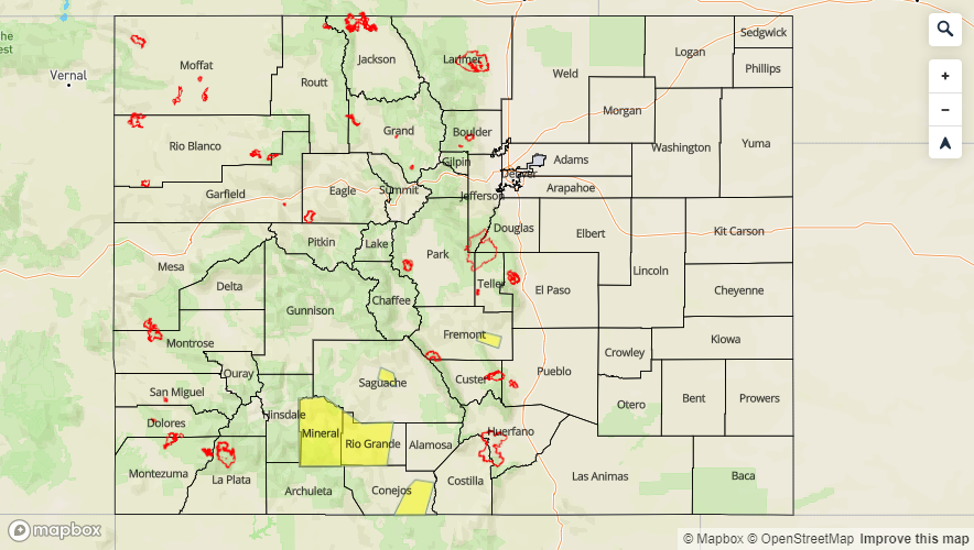
–A LOW flood threat is issued for the Arkansas River at Canon City, Saguache Creek just west of Saguache, Rio Grande River near Del Norte and Southwestern Rio Grande County/Mineral County
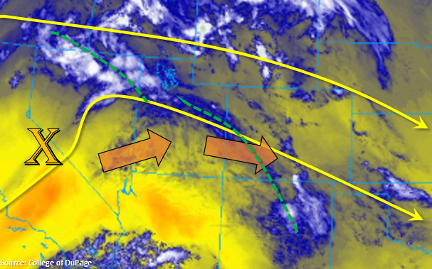
Flow will shift from more northerly to westerly throughout the day with the approaching broad and weak trough. This has started to pull more low level moisture back into the state as seen in the water vapor imagery below. With increased moisture, mid-level energy moving in from the northwest and a weak just over eastern Colorado, expect an increase in shower and thunderstorm coverage this afternoon. By early afternoon storms will kick off over the mountains and quickly spread into the adjacent plains. Storm activity will also increase over northwest Colorado with storms moving into the area from the west. Gusty winds, light rainfall and lightning will be the main threats for western Colorado and the mountains. The westerly flow will set up a dry line over the plains, which would push the heaviest rainfall to our east. However, as storms move into the eastern plains, dew points in the 40°Fs will likely increase the efficiency of the rain rates. A severe storm may be possible over the far southeast corner of the state; however, the latest model runs are pushing the best parameters into the Oklahoma and Texas Panhandles. With support from the jet, weak thunderstorms may continue over the plains and northern high terrains through midnight with activity elsewhere decreasing a couple hours after the sun sets.
High temperatures increase a couple of ticks on the thermometer this afternoon. Thus, the flooding threat for the San Juan Mountains and San Luis Valley continues. The current Flood Watch covers the Dolores River below Rico, San Luis Valley and eastern San Juan Mountains and will likely last through this weekend. A Low flood threat has been issued for the Arkansas River at Canon City, Saguache Creek just west of Saguache, Rio Grande River near Del Norte and Southwestern Rio Grande County/Mineral County today, which covers the Flood Warnings issued by NWS (as of 9AM). For the latest, tune into NWS Pueblo and Grand Junction.
Today’s Flood Threat Map
For more information on today’s flood threat, see the map below. For Zone-Specific forecasts, scroll below the map.

Zone-Specific Forecasts:
Front Range, Southeast Mountains, Raton Ridge, Palmer Ridge, Urban Corridor, Northeast Plains, Southeast Plains, Northern Mountains:
Warmer high temperatures are forecast today by a couple of degrees. Storms will form over the mountains early this afternoon and quickly spread into the adjacent plains. Coverage will be more widespread as some mid-level energy and increase in low level moisture combine. Expecting rain rates between 0.1 and 0.2 inches over the mountains and adjacent plains. Over the far eastern plains, 1-hour totals up to 0.6 inches are possible with isolated totals of 0.75 inches over the far Northeast and Southeast corners. Flooding from rainfall is not expected.
Increased flows over the Arkansas west of Pueblo will also be monitored closely over the next couple of days as gages are starting to move into Action stage. The gage at Canon City will likely move into the Minor flooding stage as early as tomorrow morning. The Arkansas gage near Avondale continues to decrease as the releases from the dam have ended for now. Please tune into your local NWS office for the latest on flood warnings, advisories and statements as they can change throughout the day.
Primetime: 2PM to Midnight
Central Mountains, San Juan Mountains, Northwest Slope, Grand Valley, Southwest Slope, San Luis Valley:
Slight increase in moisture with the northwest flow will allow for some weak showers and thunderstorms in the forecast today. The air mass is still relatively dry, so storms will be high-based and may produce some gusty winds with lightning. Max 1-hr rain rates up to 0.25 inches are possible over the Northwest Slope, but further south, expect storms to produce between 0.05 and 0.15 inches. Activity should decrease around 9PM with a couple light showers possible over the Northwest Slop through 11PM.
As of 9AM: The Flood Watch mentioned above continues for the San Juan Mountains and San Luis Valley with the addition of the Dolores River below Rico. A Low flood threat (and Flood Warning) has been issued for Saguache Creek west of Saguache, the Rio Grande near Del Norte and for western Rio Grande and Mineral Counties. Current Areal Flood Advisories issued for the following: Eagle River near Gypsum and at Red Cliff, East River at Almont, Colorado River near the CO/UT state line, Mancos River in Montezuma County, San Juan River at Pagosa Springs, Los Pinos River near Bayfield (La Plata County), La Plata River at Hesperus, Animas River at Durango, Gunnison River above Grand Junction, Tomichi Creek at Gunnison and Williams Creek upstream from Lake Cristobal (Hinsdale County).
Primetime: 2PM to 11PM