Issue Date: Monday, June 3rd, 2019
Issue Time: 8:45AM MDT
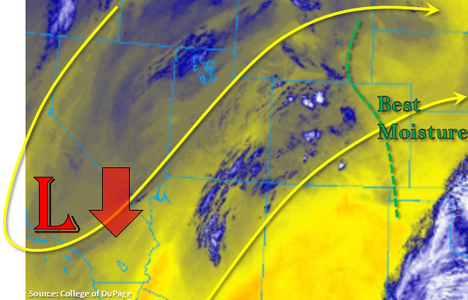
The low begins to move south towards the Baja Peninsula this afternoon, which will allow for a thermal ridge to build back to the northwest over the state. This will change upper level flow to more southwest over western Colorado with more westerly winds this afternoon over eastern Colorado. Models are also showing a surface low forming by mid-afternoon over eastern Colorado. This will pull in better low level moisture over the Northeast Plains on its north side and help scour our moisture over the Southeast Mountains and the adjacent Southeast Plains. Thus, thunderstorm activity will be more widespread over the Northeast Plains with more limited coverage over the southeast corner of the state as the storms move west.
Diurnal flow will kick off thunderstorms over the mountains and Raton Ridge by early afternoon with storm motion to the west at 15 to 20 knots. With more mid-level moisture present than low level moisture, storms will continue to be high-based, which should limit the heavy rainfall potential. Higher moisture along the Kansas/Nebraska/Colorado border over the Northeast Plains will allow some decent CAPE values to build, so an isolated severe thunderstorms may be possible. Hail up to 2 inches, gusts up to 60mph and moderate rainfall will be the main threats with the severe thunderstorms. To the west, less low level moisture will be available, so lightning, gusty winds and small hail will be the main threats over the Northern, Central and San Juan Mountains. Flooding is not forecast today.
Today’s Flood Threat Map
For more information on today’s flood threat, see the map below. For Zone-Specific forecasts, scroll below the map.

Zone-Specific Forecasts:
Front Range, Urban Corridor, Palmer Ridge, Southeast Plains, Raton Ridge, Northeast Plains:
Storms will form over the mountains and Raton Ridge this afternoon with the aid of diurnal flow and a surface low just north of the Palmer Ridge. This will pull in better moisture on its north side, so storms will be more abundant as the move west into the Northeast Plains. Max 1-hr rain rates up to 0.4 inches (west) and 1.15 inches (east) are possible. Further south, storm activity will be limited to the far southeast corner of the state. Max 1-hr rain rates over the Raton Ridge up to 0.15 inches are possible with totals up to 1 inch over the southeast corner. High bases and decent storm movement should limit the flood threat, thus there is no flood threat issued. Without any upper dynamics to support overnight thunderstorms, storms will come to an end a couple hours after sundown.
Primetime: 1PM to 10PM
Southeast Mountains, San Juan Mountains, Northern Mountains, Central Mountains, Northwest Slope, Grand Valley, Southwest Slope, San Luis Valley:
Not quite as much moisture over this area with southwest and westerly flow scouring out low-level moisture. Some weak afternoon storms will be possible over the higher terrains, but the heavier accumulations will be along and near the Continental Divide over the Central and Northern Mountains. Isolated totals up to 0.3 inches will be possible with more general totals in the 0.1 to 0.2 inch range. Small hail and gusty winds will likely accompany the stronger storms. Expect high temperatures to reach the 80°Fs in the valleys and upper 50°Fs to mid-60°Fs in the mountains. With the warm temperatures, snow melt has been occurring rapidly since Saturday. There is currently a flood advisory for the San Antonio River for minor flooding in Manassa, Sanford and Antonito possible. No flooding has been reported yet, but gages in the area remain high.
Primetime: 1PM to 9PM