Issue Date: 6/2/2019
Issue Time: 8:30 AM
A LOW FLOOD THREAT IS FORECAST TODAY FOR PORTIONS OF THE URBAN CORRIDOR, NORTHEAST PLAINS, PALMER RIDGE, SOUTHEAST PLAINS, AND RATON RIDGE.
There isn’t much change in the large-scale weather pattern as compared to yesterday, with an upper-level low still spinning over SoCal/southern NV, an upper-ridge building over the central US, and southwest flow between the two features continuing to bring some mid-level moisture to Colorado. This will lead to a very similar day as yesterday, albeit with a few more thunderstorms thanks to a weak shortwave disturbance that will pass overhead this afternoon/evening. West of the Divide, low-level moisture remains a bit lackluster, so expect activity to be high-based and produce mainly gusty winds and light rain, with a few episodes of pea-sized hail under one or two stronger storms.
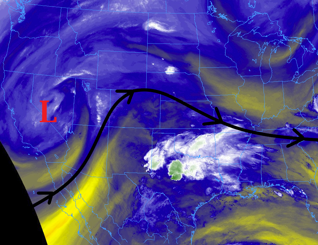
East of the Divide, the weather story is much the same as yesterday, except the threat of heavy rainfall has increased somewhat thanks to a slight uptick in low-level moisture as compared to yesterday. Scattered thunderstorms will first develop over the Front Range/Southeast Mountains around lunchtime, then spread eastward through the afternoon/evening across the plains. Large hail up to 2 inches in diameter and strong winds up to 65 mph will be the main severe threats, and an isolated tornado or two cannot be ruled out. Heavy rain will also attend stronger storms east of the mountains, so a low flash flood threat has been issued. For more details on timing and rain rates, please see the zone-specific forecast discussions below.
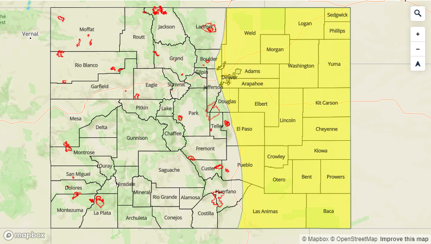
Today’s Flood Threat Map
For more information on today’s flood threat, see the map below. For Zone-Specific forecasts, jump below the map.

Zone-Specific Forecasts
Front Range, Southeast Mountains, Urban Corridor, Northeast Plains, Southeast Plains, Palmer Ridge, and Raton Ridge:
Scattered thunderstorms are expected today/tonight, developing first over the Front Range/Southeast Mountains around lunchtime, spreading eastward over the plains with time. A few of the storms will be severe, capable of producing hail up to 2 inches in diameter, strong winds up to 65 mph, and an isolated tornado or two. Heavy rainfall will also be a concern with moisture slightly increased since yesterday; however, storm motions will lessen the risk of flash flooding, so only a low flood threat is warranted. Maximum rain rates are as follows:
Front Range and Southeast Mountains: 0.25-0.5 inches/hour
Urban Corridor: 1.0-1.2 inches/hour
Palmer Ridge: 1.5-2.5 inches/hour
Northeast Plains and Southeast Plains: 2.0-2.75 inches/hour
Raton Ridge: 1.0-1.3 inches/hour
Timing: Noon – 10 PM for the Front Range/Southeast Mountains, 1 PM – 10 PM for the Urban Corridor, 2 PM – Midnight for the Palmer Ridge, Northeast Plains and Southeast Plains, 2 PM – 9 PM for the Raton Ridge
Northern Mountains, Northwest Slope, San Luis Valley, Central Mountains, San Juan Mountains, Grand Valley, and Southwest Slope:
Scattered high-based showers/thunderstorms are expected, beginning around 11 AM, maximizing coverage & intensity between 3 PM and 6 PM, then gradually diminishing and ending by 10 PM. Gusty winds, light rainfall, and occasional lightning will be the main impacts, with one or two stronger storms capable of producing up to 50 mph wind gusts in valley locations and pea-sized hail. Most rain rates will be less than 0.1 inches/hour, but maximum rain rates will be 0.2-0.5 inches/hour under the strongest storms. Storm motions will be quick enough to the northeast to avoid any flood threat concerns.