Issue Date: 6/1/2019
Issue Time: 8:55 AM
A LOW FLOOD THREAT IS FORECAST TODAY FOR PORTIONS OF THE FRONT RANGE, URBAN CORRIDOR, PALMER RIDGE, NORTHEAST PLAINS, AND SOUTHEAST PLAINS.
On the first day of Meteorological Summer, the large-scale weather pattern features an upper-level low sinking southward along the West Coast, allowing for a building ridge of high pressure over the southern/central Rockies. Embedded in the southwest flow aloft between these two pressure centers is a ribbon of decent mid-level moisture that will continue to overspread Colorado. This moisture will be the fuel behind a few scattered showers/weak thunderstorms along/west of the Continental Divide today, all of which will be high-based owing to a lack of low-level moisture. Light precipitation and gusty winds will be the main impacts associated with this activity.
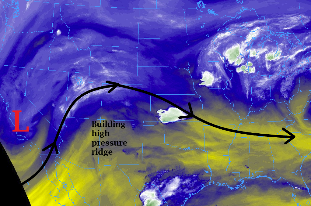
East of the Continental Divide, and mainly along/east of the Front Range/Southeast Mountains, easterly upslope flow will usher in the return of surface dewpoints in the 40s/low 50s. This increase in moisture, coupled with good daytime heating, will allow for the development of scattered thunderstorms across the area. There will be enough instability for a few of the storms to become strong/severe, with the highest relative risk over the far Southeast Plains where the combination of instability/wind shear will be most favorable. The main threats will be strong winds and hail up to 2 inches in diameter; an isolated tornado or two cannot be ruled out.
For more details on timing and rain rates, please see the zone-specific forecast discussions below.
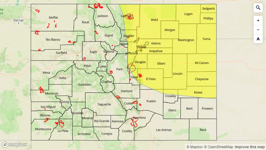
Today’s Flood Threat Map
For more information on today’s flood threat, see the map below. For Zone-Specific forecasts, jump below the map.

Zone-Specific Forecasts
Front Range, Southeast Mountains, Urban Corridor, Northeast Plains, Southeast Plains, Palmer Ridge, and Raton Ridge:
Scattered thunderstorms are expected today, beginning around lunchtime over the Front Range and Southeast Mountains, spreading eastward with time over eastern Colorado. A secondary focus for initiation besides the higher terrain will be a weak surface boundary over the far Southeast Plains; this boundary is the reason for the higher, relatively speaking, severe threat today as mentioned above. The main threats will be strong winds and hail up to 2 inches in diameter; an isolated tornado or two cannot be ruled out. Maximum rain rates are as follows:
Front Range: 0.6-1.0 inches/hour
Southeast Mountains: 0.4-0.6 inches/hour
Urban Corridor: 0.8-1.2 inches/hour
Northeast Plains, Southeast Plains, and Palmer Ridge: 1.5-2.0 inches/hour
Raton Ridge: 0.5-0.8 inches/hour
Timing: Noon – 9 PM for the Front Range and Southeast Mountains, 1 PM – 10 PM for the Urban Corridor, 1 PM – 11 for the Palmer Ridge, and 1 PM – Midnight for the Northeast Plains and Southeast Plains
Northern Mountains, Northwest Slope, San Luis Valley, Central Mountains, San Juan Mountains, Grand Valley, and Southwest Slope:
Scattered showers/weak thunderstorms are expected today as daytime heating and orographic effects work on good mid-level moisture. Due to a lack of low-level moisture, activity will be high-based, with the main impacts being gusty winds, light rainfall, and occasional lightning. Rain rates will generally be less than 0.1 inches/hour everywhere, with maximum rates of 0.15-0.30 inches/hour over the San Juan Mountains and Southwest Slope.
Timing: 11 AM – 9 PM, with an isolated, lingering shower or two until 11 PM over the higher terrain