Issue Date: 5/26/2019
Issue Time: 9:20 AM
A LOW FLOOD THREAT IS FORECAST TODAY.
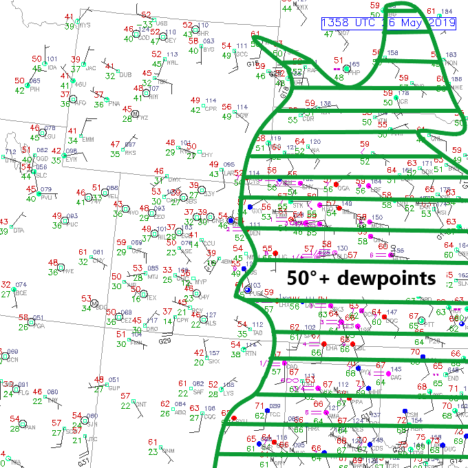
An active weather day is expected for eastern Colorado, and this can be evidenced by the return of low-level moisture. Highlighted on the surface map below is the area of 50°+F dewpoints, with a few 60°+F dewpoints sneaking into the far Southeast Plains. This moisture will be the fuel behind today’s threat of strong/severe storms for areas east of the mountains and will be sufficient enough for the introduction of a flood threat. Meanwhile, over the High Country, residual moisture that remains in place will be enough for high-based showers/thunderstorms this afternoon/evening. There are three trigger mechanisms today that will set off the thunderstorms: 1) daytime heating, 2) a disturbance aloft, and 3) a sharpening dryline over southeast Colorado. The combination of the three will provide enough forcing for scattered showers and thunderstorms across the state, with all regions getting involved, albeit some more than others.
Over the High Country, moisture is too shallow for any concerns over heavy rainfall; instead, the scattered activity today will be garden-variety and high-based, producing gusty winds, light rainfall, and occasional lightning. East of the mountains, however, moisture is sufficient for the production of strong/severe thunderstorms, as well as periods of heavy rainfall. Storm motions will be quick enough to the east/northeast to limit the flood threat, but not quick enough to avoid a low flood threat.
For more details on timing and rain rates, please see the zone-specific forecast discussions below.
Today’s Flood Threat Map
For more information on today’s flood threat, see the map below. For Zone-Specific forecasts, jump below the map.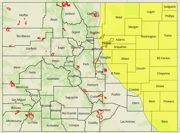

Zone-Specific Forecasts
Urban Corridor, Northeast Plains, Southeast Plains, Palmer Ridge, and Raton Ridge:
Scattered strong/severe thunderstorms are expected today/tonight, kicking off around 1 PM, and continuing into the nighttime hours. Instability, fueled by daytime heating and good moisture, will promote rapid thunderstorm development and coupled with adequate wind shear, storms will hold the potential for all severe hazards (i.e., large hail (up to 2.5 inches in diameter), strong winds (up to 70 mph), and a couple tornadoes). The bulk of thunderstorm activity is expected over the Northeast Plains and Southeast Plains, with more widely scattered storms over the Urban Corridor and Palmer Ridge. The Raton Ridge region will be behind the dry line, so isolated development there is expected to be high-based, producing mainly gusty winds and periods of light rainfall. Maximum rain rates are as follows:
Northeast Plains and Southeast Plains: 1.5-2.5 inches/hour
Urban Corridor and Palmer Ridge: 1.0-1.5 inches/hour
Raton Ridge: 0.2-0.4 inches/hour
Timing: 1 PM – 9 PM for the Raton Ridge, 1 PM – 10 PM for the Palmer Ridge, 1 PM – 11 PM for the Southeast Plains, 1 PM – Midnight for the Urban Corridor and Northeast Plains, where a Denver convergence zone will try to keep some storms going into the night.
Front Range, Southeast Mountains, Northern Mountains, Northwest Slope, San Luis Valley, Central Mountains, San Juan Mountains, Grand Valley, and Southwest Slope:
Scattered showers/storms are expected this afternoon and evening across the area, with the bulk of storm activity over the higher terrain of the Southwest Slope, San Juan Mountains, Central Mountains, Northern Mountains, Southeast Mountains, and Front Range. Most of the activity will be high-based, moving quickly to the northeast, producing gusty winds and periods of light rainfall. The best chance at wetting rainfall will be over the Front Range, where good surface moisture has backed into the mountains from the eastern plains. The maximum rain rates are as follows:
Front Range: 0.2-0.4 inches/hour
Northern Mountains and Central Mountains: 0.15-0.30 inches/hour
Southeast Mountains, San Juan Mountains, Southwest Slope, Grand Valley, and Northwest Slope: 0.1-0.2 inches/hour
San Luis Valley:
Timing: Noon – 10 PM