Issue Date: Tuesday, May 21st, 2019
Issue Time: 8:50AM MDT
–Flooding is NOT expected today
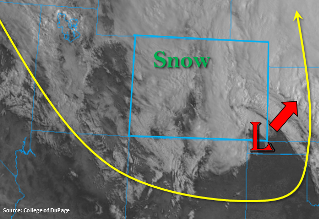
A lot of folks waking up to snow this morning as rain transitioned to snow for the lower elevations during the early evening hours on Monday. While it is somewhat unusual that there is snow this time of year, the latest date of measurable snow in Denver is June 2nd. Over the eastern plains (minus the Palmer Ridge), precipitation remained as rainfall and continues this morning. Today, the low pressure system that brought the winter weather will exit northeast into Kansas/Nebraska. However, stratiform rainfall over eastern Colorado will continue on the northwest side of the low. Expecting the rainfall to slowly decrease southwest to northeast this afternoon into this evening as the low moves out of the area. Subsidence and westerly flow will fill in over the Front Range/Southeast Mountains and Urban Corridor by early afternoon, which should decrease the chances for precipitation this afternoon. Throughout the day, the cloud cover should begin to break up (starting south first) with a few isolated, light snow storms possible over the higher terrains this afternoon.
Over western Colorado, scattered showers (valleys) and snow (mountains) are forecast to increase as some mid-level energy and residual moisture combine today. With a drier air mass moving in from the west, accumulations are expected to remain low and favor the higher terrains with slow westerly storm motion. There will be some decent accumulation over the Northern and north Central Mountains thanks to wrap around moisture from the low this morning. Expect light showers and snow to begin tonight over the southwest corner as the jet moves into the area associated with the next low pressure system. Snow levels will likely fall to 7K feet overnight; however, accumulation will be far less than last night. Flooding is not expected today.
Today’s Flood Threat Map
For more information on today’s flood threat, see the map below. For Zone-Specific forecasts, scroll below the map.
Zone-Specific Forecasts:
Raton Ridge, Southeast Plains, Urban Corridor, Palmer Ridge, Northeast Plains, Front Range, Southeast Mountains:
Precipitation will start decrease from southwest to northeast today as the low moves into Kansas. Wrap around moisture in the deformation zone will continue showers over the eastern plains. This rainfall should decrease from southwest to northeast this afternoon into this evening along with breakup of the cloud cover. Some light snow showers are possible over the higher terrains. Max 24-hr totals up to 0.4 inches (west) and 1.5 inches (northeast corner) are possible. Activity is forecast to end a couple hours after sundown, and flooding is not forecast.
Primetime: Ongoing to 8PM
Northwest Slope, Grand Valley, Southwest Slope, San Luis Valley, San Juan Mountains, Central Mountains, Northern Mountains:
Snow showers will continue over the Northern and north Central Mountains through this afternoon as wrap around moisture from the low continues. 24-hour snow totals up to 8 inches are possible tomorrow morning over the highest elevations. Scattered showers are also possible over the lower elevations, but without much moisture totals will remain under 0.25 inches. The next system approaches from the west tonight and the jet moves into the southwest corner of the state. This should initiate showers and snow (> 7K feet) over the southwest corner of the state and western, central Colorado overnight into tomorrow morning. Precipitation totals will likely be between 0.3 (valleys) and 0.75 inches (San Juan Mountains). Flooding is not expected.
Primetime: Ongoing to 8AM