Issue Date: Monday, May 20th, 2019
Issue Time: 9:30AM MDT
–Flooding is NOT expected today
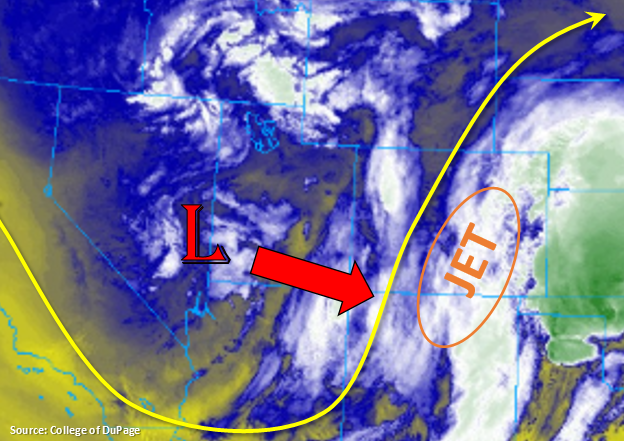
The upper closed low that is currently over the Nevada/Utah border will start to move to the southeast today, which will bring cool and wet weather statewide. By tomorrow morning it will be positioned over the southeast Colorado/New Mexico border and bring snow to the lower elevations. With an incoming jet, ample low level moisture with southwesterly flow and plenty of mid-level ascent, expect precipitation to continue throughout today and into tomorrow. Currently, surface maps are indicating heavy snowfall and rain over the southwest corner of the state and moderate snow over the Central Mountains. With southwest flow increasing throughout the day, highest snow accumulations are expected to be over the Continental Divide, with all of the higher terrains receiving some snow accumulation through tomorrow morning. Over the southeast Plains in Baca and Powers Counties, showers continue from a wave of storms that moved through the Southeast Plains overnight.
For today, expect an uptick in widespread showers and snow (> 9K ft). For western Colorado, storm motion will have more of a southerly component during the day, but as the low moves into the southwest corner tonight, storms will wrap around it counterclockwise giving more of a northerly component to the motion. Expecting all zones to get some precipitation with snow levels dropping to 7K ft overnight. Overnight, precipitation should be confined to the mountains, and snow accumulations are expected to be highest over the San Juan Mountains by tomorrow morning.
To the east, the heaviest precipitation over the next 24-hours is expected along a line from Pueblo County to eastern Weld/western Logan Counties as upslope flow and a boundary set up. Some severe thunderstorms with hail are possible with these storms this afternoon, but tonight temperatures drop off significantly. This means there will likely be snow over the Cheyenne and Palmer Ridges by morning with the snow level around 6K feet. There is an outside chance of snow within the Urban Corridor as well, so be sure to bring in outdoor plants or cover them overnight. As the low moves into the southeast corner of the state tonight, downsloping winds to the south should decrease precipitation activity over the Southeast Plains and Raton Ridge. As mentioned, favorable upper level dynamics will keep activity going through the night over the Southeast Mountains, Front Range and Urban Corridor.
Interesting flood forecast as the main threat will occur this afternoon over the Palmer Ridge. Max 1-hr rain rates hover around flood threat criteria if stronger (severe) thunderstorms are able to develop with dew points in the upper 40°Fs to low 50°Fs. However, dry soils and green vegetation decrease the chance for widespread flooding. At this time, going with no flood threat, but should the threat increase enough to warrant a Low threat, a PM update will be issued.
Today’s Flood Threat Map
For more information on today’s flood threat, see the map below. For Zone-Specific forecasts, scroll below the map.
Zone-Specific Forecasts:
Raton Ridge, Southeast Plains, Urban Corridor, Palmer Ridge, Northeast Plains:
Upper dynamics, increased low level moisture and a boundary will help form a line of thunderstorms this afternoon over the adjacent plains around the Palmer Ridge/Southeast Plains intersect. There is a possibility for some severe storms in this area with hail up to 1.25 inches. Max 1-hr rain rates up to 1.5 inches are possible with 3-hour totals just under 2 inches. Expecting showers to become more widespread as an MCS quickly forms with the upper air support and moist boundary layer. Max 1-hr rain rates will drop to 0.3 to 0.7 inches when this occurs. Storms will have northerly motion throughout the day with decreasing rainfall from south to north this afternoon as the low moves into the southeast corner of the state. Snow levels drop off tonight, so ongoing, overnight storms will likely cross over into snow by morning over the Palmer and Cheyenne Ridges. There is a slight chance for snow across the Urban Corridor by morning as well. Flooding is not forecast.
Primetime: 11AM to Tuesday morning
Northwest Slope, Grand Valley, Southwest Slope, San Luis Valley:
Southwest flow and the approaching low will pull multiple bands of rainfall with a couple thunderstorms across the lower elevations this morning into this afternoon, so expect an increase in storms throughout the day. Storm motion will be south to north this afternoon and switch to more northerly overnight as the low moves into the area. Since moisture decreases to the north, the highest 24-hr totals are forecast over the Southwest Slope where isolated totals up to 0.7 inches could accumulate. Over the Grand Valley totals up to 0.3 inches are possible. Rainfall is also likely over the Northwest Slop with totals remaining under 0.1 inches.
Primetime: Ongoing to Tuesday morning
Front Range, Northern Mountains, Southeast Mountains, San Juan Mountains, Central Mountains:
Snow level may drop throughout the day some, but for the most part, expecting all precipitation to fall as snow above ~9K ft. Expecting coverage of the precipitation to pick up throughout the day as the low begins to approach and southwest flow increases. The highest 24-hour snow accumulations are expected along the Continental Divide where totals could reach 10-12 inches. More general totals in the 4-8 inch range are forecast for other areas.
Primetime: Ongoing to Tuesday morning