Issue Date: 6/16/2015
Issue Time: 10:50 AM
A MODERATE FLOOD THREAT IS FORECAST FOR PORTIONS OF THE URBAN CORRIDOR, PALMER RIDGE, AND NORTHEAST PLAINS. A LOW FLOOD THREAT IS FORECAST FOR PORTIONS OF THE FRONT RANGE, URBAN CORRIDOR, PALMER RIDGE, NORTHEAST PLAINS, SOUTHEAST MOUNTAINS, RATON RIDGE, SOUTHEAST PLAINS, SAN JUAN MOUNTAINS, CENTRAL MOUNTAINS, AND NORTHERN MOUNTAINS.
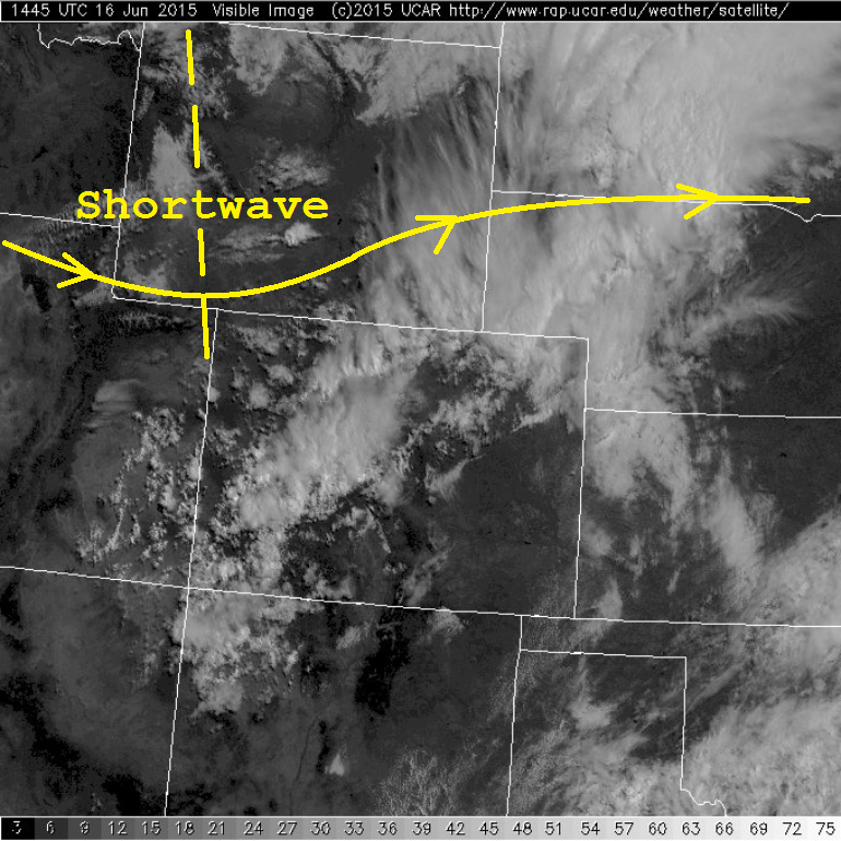
For today, storm coverage takes a slight downturn as the mid- and upper-levels of the atmosphere become drier/weakly subsident from west-to-east with time. This is due to the passing shortwave, noted on the visible satellite image below. Associated with this shortwave is a weak lobe of vorticity which will drag south across Colorado, firing off scattered storms across the higher terrain, which will then move eastward with time. Additionally, ahead of the shortwave, scattered strong-to-severe thunderstorms are expected across northeastern Colorado as daytime heating combines with ample low-level moisture. The Palmer Divide will provide support for a few isolated strong-to-severe storms across the southern Urban Corridor and Palmer Ridge regions, as well.
While storm coverage will take an overall downturn today, do not let that lull you to sleep with respect to heavy rainfall and potential flooding issues. Heavy rain will still be a threat, especially in the moderate flood threat areas outlined below. With saturated soils and streams already running high/out of their banks, any additional rainfall will cause flood-prone areas to react quickly. As always, we urge everyone to stay away from high-flowing streams/rivers because saturated banks are unstable and can give way, throwing you into the swift current. Please see the zone-specific forecast discussions below for more details regarding timing and rain rates.
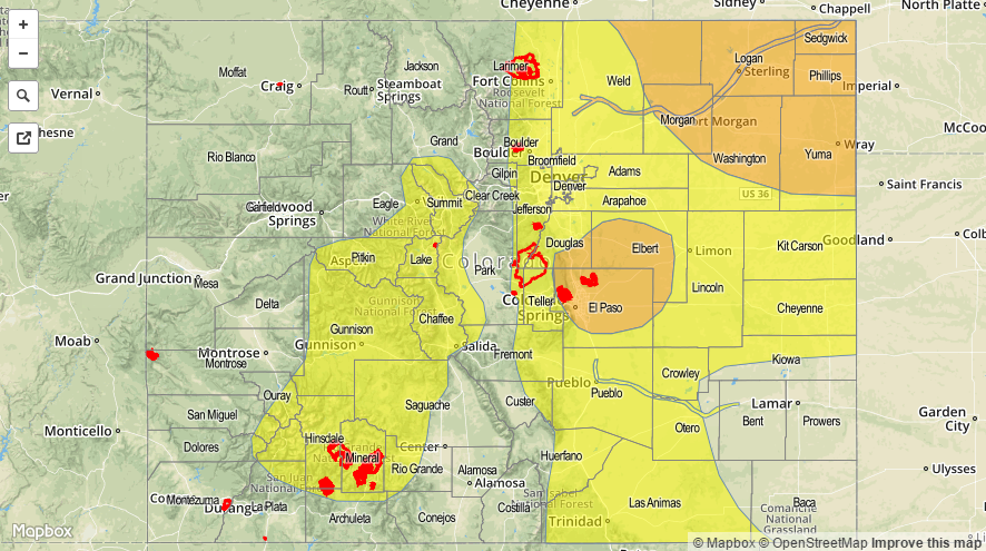
Today’s Flood Threat Map
For more information on today’s flood threat, see the map below (hover over threat areas for more details). For Zone-Specific forecasts, jump below the map.

Zone-Specific Forecasts
Front Range, Urban Corridor, Palmer Ridge, Northeast Plains, Southeast Plains, Southeast Mountains, and Raton Ridge:
Scattered showers and thunderstorms expected this afternoon and evening as the shortwave translates from west-to-east. Maximum rain rates will vary across these regions, so see below for a breakdown:
Northeast Plains: 2.0-2.5 inches/hour
Urban Corridor, Palmer Ridge, and Raton Ridge: 1.2-1.8 inches/hour
Southeast Plains: 0.7-1.2 inches/hour
Southeast Mountains and Front Range: 0.6-1.1 inches/hour
Timing: 11 AM – 10 PM, with a few showers/thunderstorms continuing over the Northeast Plains until around midnight.
Northern Mountains, Northwest Slope, Central Mountains, San Juan Mountains, San Luis Valley, Grand Valley, and Southwest Slope:
Scattered showers and thunderstorms, mainly over the higher terrain as upper-levels become weakly subsident this afternoon and orographic effects become the main focus. The San Juan Mountains will feature the greatest coverage of storms overall, and also feature the relative highest rain rates.
Most storms will produce rain rates of 0.25-0.4 inches/hour, with the San Juan Mountains holding the chance for maximum rain rates in the 0.8-1.1 inches/hour range.
Timing: 11 AM – 9 PM, with a few showers lingering after midnight across the highest terrain.