Issue Date: Thursday, May 9th, 2019
Issue Time: 8:15AM MDT
— Flooding is NOT expected today
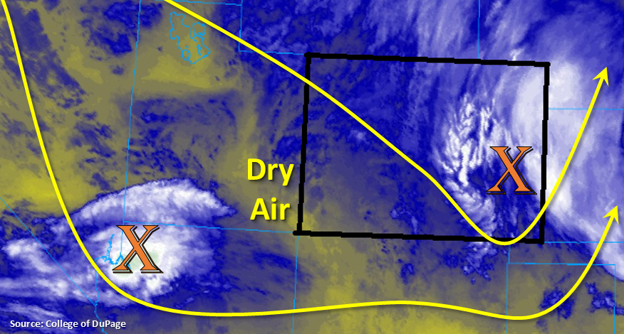
Cold temperatures and snow over the mountains and lower elevations in eastern Colorado. Not much sticking along the Urban Corridor, and we should start to the snow turning over to rain with a little daytime heating. Low temperatures are just above freezing south of Colorado Springs, so rain is falling in Pueblo and La Junta. A little bit warmer start to the day over the lower elevations in western Colorado. A drier air mass is currently moving into the area, though it won’t be long until the next shortwave enters from the west. Highs here should reach the mid-50°Fs to 60°F over the lower elevations.
Two systems should affect the weather today. The first is marked over eastern Colorado. This trough will keep light, scattered showers going over the plains through the early afternoon. By then, a little daytime heating and eastward movement of the trough will help break up some of the cloud cover. Still not expecting high temperatures to reach above 50°F. The other system is currently marked with an “X” over the Utah/Arizona/Nevada border. Expecting shower activity to pick up late this afternoon over the Southwest Slope as this wave approaches. Overnight, this should help provide lift for some snow and light showers over the eastern San Juan Mountains, San Luis Valley and Southeast Mountains. Lastly, over the mountains this afternoon, left over mid-level energy, moisture and the diurnal heating pattern should increase showers and snow over the higher terrains. The activity will first start over the Central, Northern and northern San Juan Mountains, then over the Southeast Mountains and Front Range. With the stable atmosphere in the adjacent (eastern) plains, not expecting much precipitation as rain will dissipate away from the lift. There may be a bit more rainfall over the northern Urban Corridor with extra convergence along the Cheyenne Ridge. Flooding is not expected today.
Today’s Flood Threat Map
For more information on today’s flood threat, see the map below. For Zone-Specific forecasts, scroll below the map.

Zone-Specific Forecasts:
Front Range, Urban Corridor, Southeast Mountains, Palmer Ridge, Raton Ridge, Southeast Plains, Northeast Plains:
Snow at elevations higher than 8K ft today. Otherwise, snow turning to rain is forecast over the lower elevations. Rain over the plains is expected to be more stratiform in nature and ending by early afternoon. Totals up to 0.3 inches are possible. To the west, general snow totals in the range of 2-6 inches are possible favoring the northern Front Range. Overnight, a second wave will produce some more snow over the Southeast Mountains. This will likely cause totals up to 12 inches at the highest elevations by morning. Clearing over the plains will cause freezing temperatures overnight, so a Freeze Watch is in place.
Primetime: Ongoing to 6AM
Northwest Slope, Grand Valley, Southwest Slope, Northern Mountains, San Luis Valley, San Juan Mountains, Central Mountains:
Warmer temperatures for the lower elevations this afternoon as there is a break and a bit of dry air between the two systems. Snow showers are expected to pick up over the higher terrains this afternoon with some left over mid-level energy, moisture and minimal instability. Precipitation will generally favor the Central Mountains and should end around sundown. More snow is expected overnight over the eastern San Juan Mountains as the next wave passes through. Snow totals in the range of 5-12 inches are possible by morning.
Primetime: Ongoing to 7AM