Issue Date: Wednesday, May 8th, 2019
Issue Time: 9:10AM MDT
— Flooding is NOT expected today
Much cooler temperatures to start the morning as a cold front moved through the state last night. A secondary, stronger front is expected this afternoon with the surge of cold air beginning around noon over northern Colorado. This surge of northerly, cold wind will knock down high temperatures over the majority of the state today. Forecasting a drastic drop in the freezing level this afternoon into tonight. Snow levels are currently above 10K feet, but are expected to fall to 6K feet by tonight. This means heavy snowfall for the higher elevations and a few inches in the foothills by morning. It is also likely the lower elevations (5-6K ft) will accumulate some light snow on the grass by the morning commute.
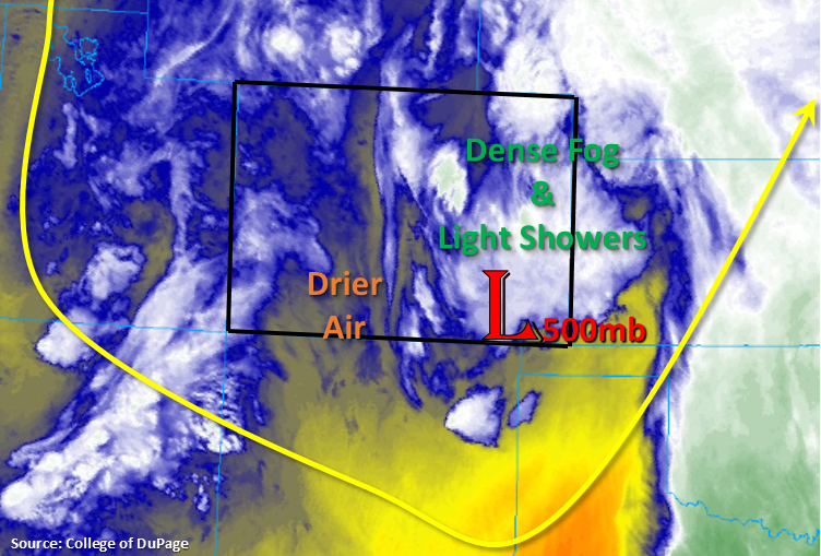
The low pressure system that has kept an active pattern in play is currently over eastern Colorado. This is helping produce cloudy, foggy and rainy conditions over the eastern portion of Colorado. A bit of dry air (yellow) has worked its way into central and southern Colorado, so skies have more scattered cloud cover with light snowfall being reported over some mountain stations. However, the next shortwave and associated rainfall has started to move in from the southwest and west, which is producing light rainfall over lower elevations along the Utah/Colorado border. As expected, precipitation at the higher elevations (9-10K+ ft) is falling as snow, which will continue into Thursday. The first front is currently stalled out over western, central Colorado, so expected colder temperatures to the north of this feature with high temperatures a few degrees warmer south this afternoon. This is also the difference between rain and snow. Later this afternoon, the freezing level will begin to drop with the cold front and will be reinforced with evaporate cooling, so about this time, the lower elevations (7-8K ft) rainfall will start to turn to snow.
As the next shortwave navigates eastward across the state, showers and snow are expected to pick up in coverage over the higher terrains by early afternoon. A few of these showers may affect the (eastern) adjacent plains with their slow westerly storm motion. With a stable atmosphere, they should dissipate as the move away from the lift (mountains). Overnight, the main area of precipitation (snow) will be over the eastern San Juan Mountains, Southeast Mountains and Raton Ridge. Even the San Luis Valley is forecast to get in on the action, although totals will be much lower (up to 0.25 inches). With the majority of the precipitation falling as snow overnight, not too worried about flooding over the Spring Creek burn scar. Icy conditions may also be possible over the Palmer Divide (Monument Hill) during the morning commute. Winter conditions are forecast through Thursday, and flooding is not expected.
Today’s Flood Threat Map
For more information on today’s flood threat, see the map below. For Zone-Specific forecasts, scroll below the map.
Zone-Specific Forecasts:
Southeast Plains, Northeast Plains:
The surface winds are forecast to be northerly over eastern Colorado today, so this should keep the atmosphere stable and relatively cold. It also means organized thunderstorm activity this afternoon is not forecast, which should keep the flood threat minimal as rainfall rates in the range of 0.25 inches to 0.5 inches per hour are expected. However, as the trough slowly pulls to the northeast throughout the day, it will provide lift (along with the cold front) for continued light to moderate showers over the eastern plains. Coverage is expected to decrease into the early evening as the mid-level energy moves east. However, the next set of cold showers will arrive by early morning as the next shortwave moves through the area. So another soggy to start tomorrow with 24-hr totals up to 1.4 inches possible.
Primetime: Ongoing with a break in the early evening to midnight
Front Range, Urban Corridor, Southeast Mountains, Palmer Ridge, Raton Ridge:
Fog and low level clouds are being reported once again this morning. Shower coverage is expected to pick up by midday with freezing levels dropping by early evening to 7K ft. By morning, snow will be likely over the Urban Corridor with icy conditions over the Raton Ridge and Palmer Ridge. Max 1-hr rain rates up to 0.2 inches (east) and 0.5 inches (west). Snow totals by morning will be highest over the Southeast Mountains and Raton Ridge.
Snowfall:
8-16 inches are over the Southeast Mountains and Front Range
4-6 inches over the Foothills, Palmer Ridge and Raton Ridge
1-4 inches over the Urban Corridor
Primetime: Noon to 7AM
Northwest Slope, Grand Valley, Southwest Slope, Northern Mountains, San Luis Valley, San Juan Mountains, Central Mountains:
Complicated forecast with rain already starting near the Colorado/Utah border. With the cold front dropping south, snowfall levels are forecast to drop quickly. If the cold front and max lift from the shortwave coincide over the Central Mountains during peak heating, some very heavy snowfall rates can be expected. Snow totals over the Central and Northern Mountains are expected to be between 10 and 20 inches by morning. The eastern San Juan Mountains may get between 10 and 15 inches though these totals are expected to be widespread. Over the lower elevations up to 0.5 inches may fall in the 24-hour period (with general totals closer to 0.2 inches) and greatest coverage is forecast over the Grand Valley and Southwest Slope.
Primetime: Ongoing to 7AM