Issue Date: Wednesday, May 1st, 2019
Issue Time: 8:25AM MDT
— Flooding is NOT expected today
Welcome back to the FTB! We’re looking forward to a successful 2019 season serving you.
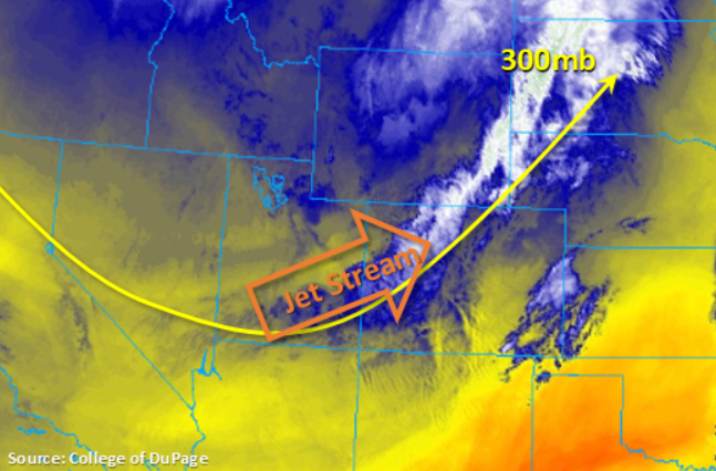
Colorado weather has welcomed back the FTB in the most Colorado way possible – a mix of snow and rain to kick off May! Currently a cold front, associated with the upper level trough in the water vapor imagery below, has moved through western Colorado. This has helped provide lift for some moderate rainfall and snow above 8000 ft. Expecting this feature to continue to move east throughout the day, which should confine the rainfall and snow to the higher elevations through this afternoon. Clear skies behind the trough is expected to cause some very cold temperature overnight. A freeze watch is in effect for the lower elevations of the Grand Valley and Northwest Slope through tomorrow morning.
To the east, there are reports of heavy fog over the eastern plains with some light pockets of fog along the Front Range. Expecting the fog to start to break up with the daytime heating, first along the Front Range and then east. As the main feature moves eastward, expect an uptick in shower activity over the Front Range and Southeast Mountains early this afternoon. The adjacent plains and eastern plains may be able to get a bit more daytime heating, which would allow for marginal CAPE to build before the cold front slides through this afternoon. This and the upper level jet are expected to help initiate thunderstorms and widespread, light to moderate rainfall south and east of Denver later this afternoon. A storm or two may become severe over the far Southeast Plains where better dynamics are in place. Post-frontal upslope flow may also produce some light showers along the southern Front Range and Southeast Mountains this evening and overnight before the upper level trough exits the state to the east. Flooding is not expected today.
Today’s Flood Threat Map
For more information on today’s flood threat, see the map below. For Zone-Specific forecasts, scroll below the map.

Zone-Specific Forecasts:
Palmer Ridge, Front Range, Urban Corridor, Northeast Plains, Southeast Plains, Raton Ridge, Southeast Mountains:
Fog early this morning with clearing expected by midday. Increased shower activity is expected from west to east with rain rates up to 0.15 inches/hour over the southern Front Range and Southeast Mountains. More robust storms are expected over the adjacent plains and southeast Colorado with a severe thunderstorm or two possible over the far Southeast Plains. Moderate rainfall is possible with rain rates up to 0.25 inches/hour (west along the Palmer Divide) and 0.5 inches/hour (east). Scatter storms may persist this evening and overnight along the southern Front Range and Southeast Mountains, but rainfall totals are expected to be under 0.2 inches. Flooding is not expected.
Primetime: 1PM to Midnight
Northwest Slope, Grand Valley, Southwest Slope, Northern Mountains, San Luis Valley, San Juan Mountains, Central Mountains:
Moderate showers and snow for elevations above 8000 feet are currently ongoing associated with the passing trough and jet stream. Expecting showers to be confined to the higher terrains of the Central and San Juan Mountains through late morning and afternoon as the main feature slides east. Rain rates up to 0.1 inches/hour are possible with totals around 0.5 inches possible over the higher elevations of the San Juan Mountains. Freezing conditions are expected over the lower valleys tonight due to clearing skies. A Freeze Watch is in effect through late tomorrow morning. Flooding is not expected today.
Primetime: 8AM to 4PM