Issue Date: 6/15/2015
Issue Time: 10:45 AM
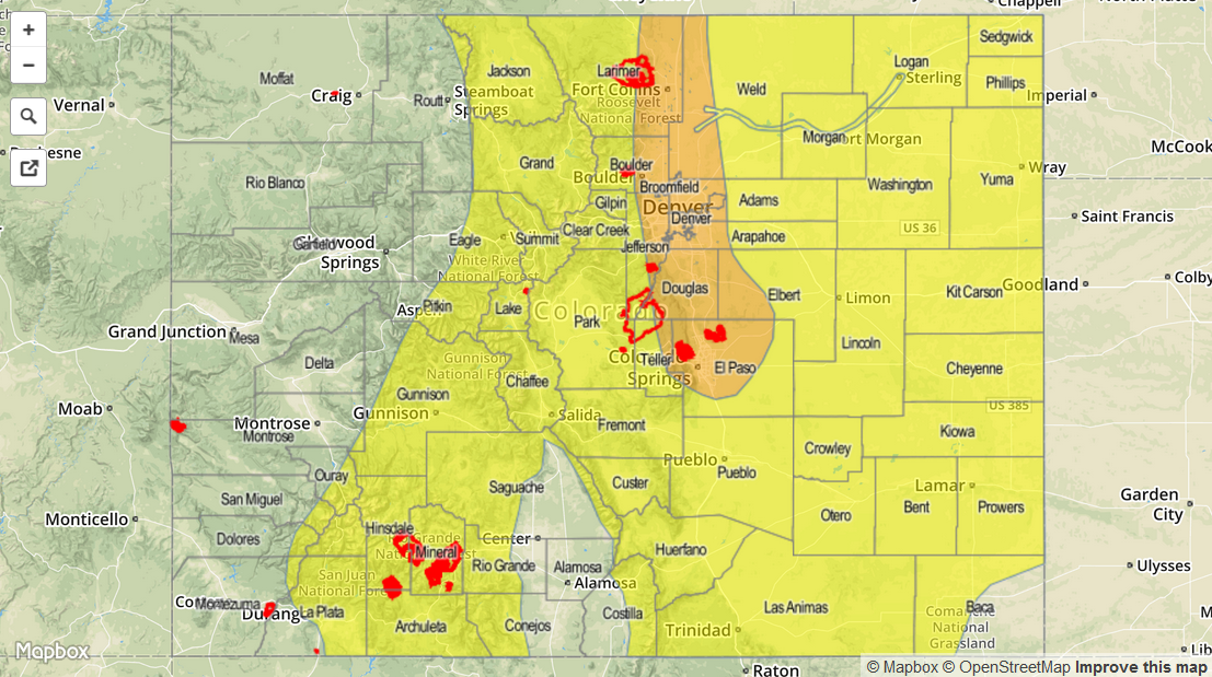
A MODERATE FLOOD THREAT IS FORECAST FOR PORTIONS OF THE FRONT RANGE, URBAN CORRIDOR, AND PALMER RIDGE. A LOW FLOOD THREAT IS FORECAST FOR PORTIONS OF THE NORTHEAST PLAINS, SOUTHEAST PLAINS, RATON RIDGE, NORTHERN MOUNTAINS, CENTRAL MOUNTAINS, SOUTHEAST MOUNTAINS, AND SAN JUAN MOUNTAINS.
Today has started off pleasant across much of the state, with only the northeast quadrant of the state experiencing expansive cloud cover thanks to a passing cool front. The cool front will continue to drop south across Eastern Colorado today, leaving moist, upslope flow in its wake. This cool front will contribute much of the ingredients responsible for today’s moderate flood threat area, and will be assisted by a mid-level disturbance moving across Colorado from the west this afternoon/evening. During the afternoon and early evening hours, daytime heating will contribute to an increase in instability which will support a few strong-to-severe storms capable of producing large hail (up to 1.75 inches in diameter) and damaging winds (gusts up to 55-70 mph).
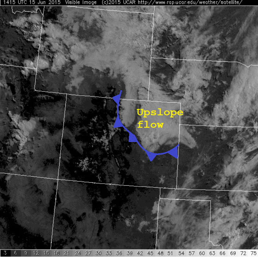
Rain production will be efficient within today’s storms as precipitable water values climb to near, or just above an inch, along and east of the Front Range/Southeast Mountains. With streams and rivers already running high thanks to snowmelt and saturated soils due to the active weather pattern we have been immersed in, the moderate flood threat is warranted as any additional rainfall will cause flood-prone areas to react quickly. Showers and thunderstorms will diminish between sunset and midnight, with a few overnight showers and thunderstorms possible over the higher terrain of Northern Colorado.
Today’s Flood Threat Map
For more information on today’s flood threat, see the map below (hover over threat areas for more details). For Zone-Specific forecasts, jump below the map.

Zone-Specific Forecasts
Front Range, Urban Corridor, Palmer Ridge, Northeast Plains, Southeast Plains, Southeast Mountains, and Raton Ridge:
Scattered showers and thunderstorms will first develop over the mountains late this morning as the mid-level disturbance moves in from the west, pushing/developing to the east with time. Maximum rain rates will be 1.2-2.0 inches/hour over the Front Range, Urban Corridor, and Southeast Plains; near 1.5-2.5 inches/hour over the Northeast Plains and Palmer Ridge; 1.0-1.5 inches/hour over the Raton Ridge and Southeast Mountains.
Timing: 11 AM – Midnight, with a few showers and thunderstorms continuing after midnight, mainly over northern portions of the Front Range, Urban Corridor, and Northeast Plains.
Northern Mountains, Northwest Slope, Central Mountains, San Juan Mountains, San Luis Valley, Grand Valley, and Southwest Slope:
Scattered showers and thunderstorms, beginning late this morning and continuing through the evening and into the nighttime hours. A few showers and weak thunderstorms will continue into the overnight hours, mainly across the Northern and Central Mountains. Rain rates will typically be 0.25-0.5 inches/hour, with the stronger storms producing 0.7-1.0 inches/hour.
Timing: 11 AM – Midnight, with a few showers continuing into the early morning hours over the Northern and Central Mountains.